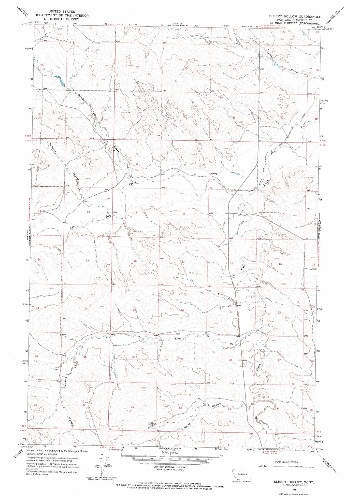
Sleepy Hollow Topo Map Montana
To zoom in, hover over the map of Sleepy Hollow
USGS Topo Quad 47106a3 - 1:24,000 scale
| Topo Map Name: | Sleepy Hollow |
| USGS Topo Quad ID: | 47106a3 |
| Print Size: | ca. 21 1/4" wide x 27" high |
| Southeast Coordinates: | 47° N latitude / 106.25° W longitude |
| Map Center Coordinates: | 47.0625° N latitude / 106.3125° W longitude |
| U.S. State: | MT |
| Filename: | o47106a3.jpg |
| Download Map JPG Image: | Sleepy Hollow topo map 1:24,000 scale |
| Map Type: | Topographic |
| Topo Series: | 7.5´ |
| Map Scale: | 1:24,000 |
| Source of Map Images: | United States Geological Survey (USGS) |
| Alternate Map Versions: |
Sleepy Hollow MT 1965, updated 1969 Download PDF Buy paper map Sleepy Hollow MT 2011 Download PDF Buy paper map Sleepy Hollow MT 2014 Download PDF Buy paper map |
1:24,000 Topo Quads surrounding Sleepy Hollow
Ada Creek |
Maxwell Coulee |
Coal Creek |
Flowing Well |
Cemetery Coulee |
Cohagen Ne |
Hafla School |
Whiteside Ranch |
Hedstrom Lake Nw |
Hedstrom Lake |
Cohagen |
Calamity Coulee |
Sleepy Hollow |
Tree Coulee School |
Hedstrom Lake Se |
Christenson Reservoir |
Hillside |
Coleman Coulee |
Little Chalk Butte |
Crow Rock |
Needle Butte |
Clear Water Reservoir |
Red Buttes |
Rock Springs School |
Crow Rock Se |
> Back to 47106a1 at 1:100,000 scale
> Back to 47106a1 at 1:250,000 scale
> Back to U.S. Topo Maps home
Sleepy Hollow topo map: Gazetteer
Sleepy Hollow: Canals
Little Dry Water Users Association Canal elevation 772m 2532′Sleepy Hollow: Dams
Hawks Nest Number 1 Dam elevation 800m 2624′Sleepy Hollow: Populated Places
Watson Flats (historical) elevation 775m 2542′Sleepy Hollow: Post Offices
Watson Flats Post Office (historical) elevation 775m 2542′Sleepy Hollow: Streams
Hawks Nest Creek elevation 780m 2559′Uall Creek elevation 771m 2529′
Sleepy Hollow: Valleys
Saurs Coulee elevation 798m 2618′Sleepy Hollow elevation 793m 2601′
Witchie Coulee elevation 796m 2611′
Sleepy Hollow: Wells
15N42E35DCDB01 Well elevation 851m 2791′Sleepy Hollow digital topo map on disk
Buy this Sleepy Hollow topo map showing relief, roads, GPS coordinates and other geographical features, as a high-resolution digital map file on DVD:
Eastern Montana & Western North Dakota
Buy digital topo maps: Eastern Montana & Western North Dakota