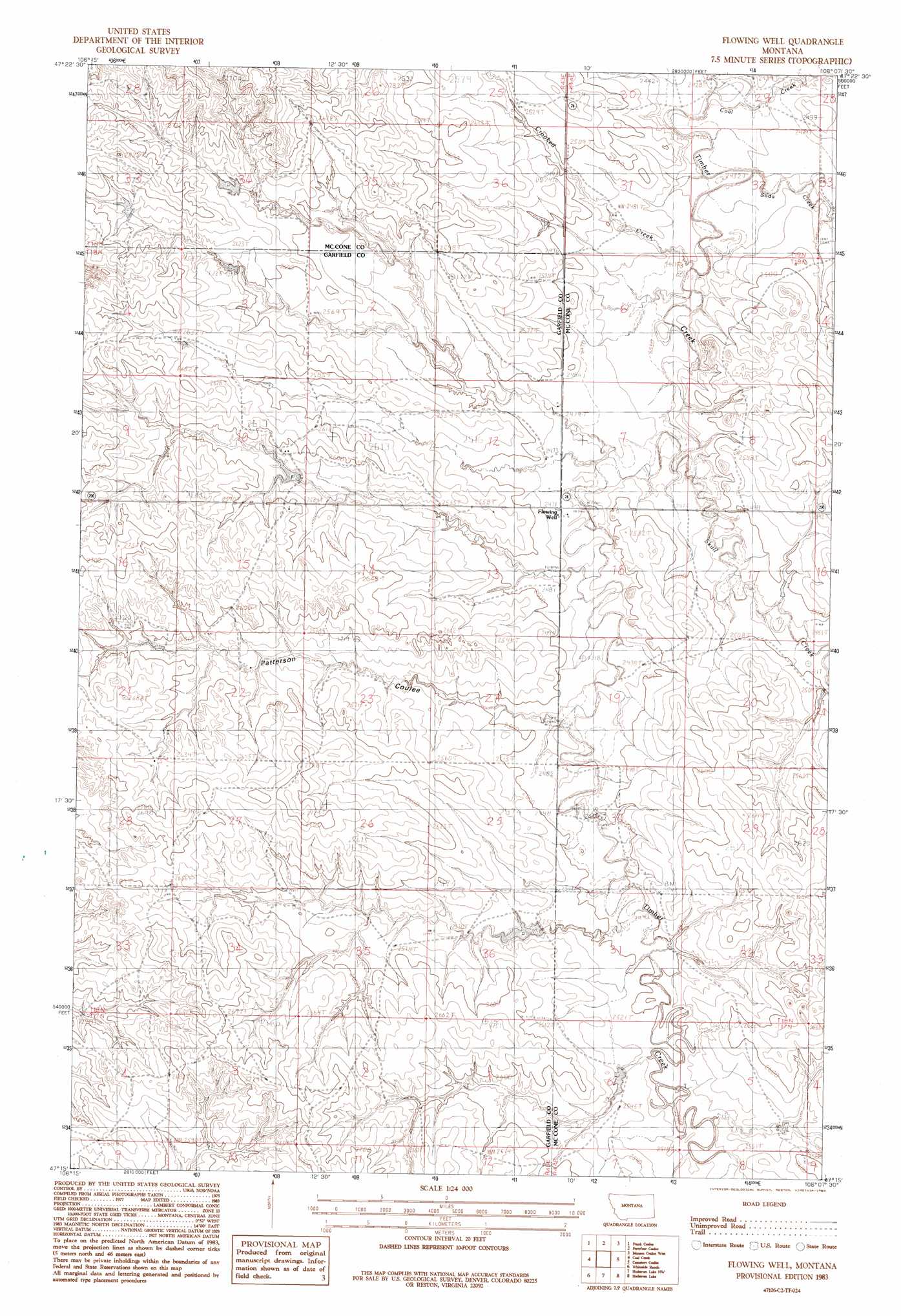
Flowing Well Topo Map Montana
To zoom in, hover over the map of Flowing Well
USGS Topo Quad 47106c2 - 1:24,000 scale
| Topo Map Name: | Flowing Well |
| USGS Topo Quad ID: | 47106c2 |
| Print Size: | ca. 21 1/4" wide x 27" high |
| Southeast Coordinates: | 47.25° N latitude / 106.125° W longitude |
| Map Center Coordinates: | 47.3125° N latitude / 106.1875° W longitude |
| U.S. State: | MT |
| Filename: | o47106c2.jpg |
| Download Map JPG Image: | Flowing Well topo map 1:24,000 scale |
| Map Type: | Topographic |
| Topo Series: | 7.5´ |
| Map Scale: | 1:24,000 |
| Source of Map Images: | United States Geological Survey (USGS) |
| Alternate Map Versions: |
Flowing Well MT 1983, updated 1983 Download PDF Buy paper map Flowing Well MT 2011 Download PDF Buy paper map Flowing Well MT 2014 Download PDF Buy paper map |
1:24,000 Topo Quads surrounding Flowing Well
Flat Creek School |
Short Creek |
Nelson Creek Bay |
Rodgers Hall |
Weldon |
Hagen Gap |
Frank Coulee |
Fortyfour Coulee |
Johnson Coulee West |
Johnson Coulee East |
Maxwell Coulee |
Coal Creek |
Flowing Well |
Cemetery Coulee |
Beauty Creek |
Hafla School |
Whiteside Ranch |
Hedstrom Lake Nw |
Hedstrom Lake |
Berry School |
Calamity Coulee |
Sleepy Hollow |
Tree Coulee School |
Hedstrom Lake Se |
Heitz School |
> Back to 47106a1 at 1:100,000 scale
> Back to 47106a1 at 1:250,000 scale
> Back to U.S. Topo Maps home
Flowing Well topo map: Gazetteer
Flowing Well: Dams
Frady Number 1 Dam elevation 765m 2509′Frady Number 3 Dam elevation 803m 2634′
Fradys Reservoir Dam elevation 798m 2618′
Gerold Gibbs Dam elevation 774m 2539′
Flowing Well: Parks
Dinosaurs Historical Marker elevation 753m 2470′Flowing Well: Populated Places
Paris (historical) elevation 762m 2500′Flowing Well: Post Offices
Paris Post Office (historical) elevation 762m 2500′Flowing Well: Streams
Coal Creek elevation 736m 2414′Crooked Creek elevation 740m 2427′
Skull Creek elevation 747m 2450′
Soda Creek elevation 742m 2434′
Flowing Well: Valleys
Patterson Coulee elevation 754m 2473′Flowing Well: Wells
17N44E08AAAD01 Well elevation 795m 2608′18N43E02CC__01 Well elevation 801m 2627′
18N43E04DB__01 Well elevation 823m 2700′
18N43E10ACD_01 Well elevation 803m 2634′
18N43E10DABD01 Well elevation 788m 2585′
18N43E12AAAB01 Well elevation 759m 2490′
18N43E13AAAA01 Well elevation 754m 2473′
18N43E13BAAA01 Well elevation 777m 2549′
18N43E13DD__01 Well elevation 768m 2519′
18N43E14AA__01 Well elevation 770m 2526′
18N43E15CD__01 Well elevation 794m 2604′
18N43E24AAAB01 Well elevation 764m 2506′
18N43E28AABA01 Well elevation 807m 2647′
18N43E28CD__01 Well elevation 813m 2667′
18N44E08BAAB01 Well elevation 769m 2522′
18N44E16CCCB01 Well elevation 755m 2477′
18N44E19BDAD01 Well elevation 750m 2460′
18N44E20BABC01 Well elevation 766m 2513′
18N44E30BDCA01 Well elevation 756m 2480′
18N44E30CDDC01 Well elevation 790m 2591′
19N43E25DAAC01 Well elevation 771m 2529′
19N44E29CBBD01 Well elevation 737m 2417′
19N44E31CADB01 Well elevation 758m 2486′
19N44E35DDDD01 Well elevation 803m 2634′
Flowing Well digital topo map on disk
Buy this Flowing Well topo map showing relief, roads, GPS coordinates and other geographical features, as a high-resolution digital map file on DVD:
Eastern Montana & Western North Dakota
Buy digital topo maps: Eastern Montana & Western North Dakota