Willis Buttes Topo Map Montana
To zoom in, hover over the map of Willis Buttes
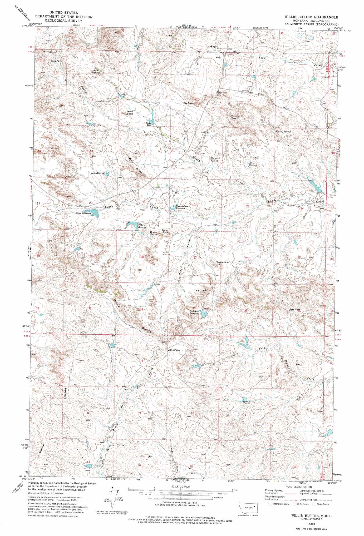
USGS Topo Quad 47106g1 - 1:24,000 scale
| Topo Map Name: | Willis Buttes |
| USGS Topo Quad ID: | 47106g1 |
| Print Size: | ca. 21 1/4" wide x 27" high |
| Southeast Coordinates: | 47.75° N latitude / 106° W longitude |
| Map Center Coordinates: | 47.8125° N latitude / 106.0625° W longitude |
| U.S. State: | MT |
| Filename: | o47106g1.jpg |
| Download Map JPG Image: | Willis Buttes topo map 1:24,000 scale |
| Map Type: | Topographic |
| Topo Series: | 7.5´ |
| Map Scale: | 1:24,000 |
| Source of Map Images: | United States Geological Survey (USGS) |
| Alternate Map Versions: |
Willis Buttes MT 1973, updated 1977 Download PDF Buy paper map Willis Buttes MT 2011 Download PDF Buy paper map Willis Buttes MT 2014 Download PDF Buy paper map |
1:24,000 Topo Quads surrounding Willis Buttes
Milk River Hills |
Kintyre |
Frazer |
Oswego |
Flynn Creek South |
Bobcat Creek |
Mcrae Springs |
Pasture Creek |
Turtle Creek |
Emily Coulee |
Spring Creek Bay |
Sand Arroyo |
Willis Buttes |
Shade Creek |
Sadie Coulee |
Ash Creek East |
Bug Creek |
Crow Springs |
Figure Eight Creek |
Pedigo Coulee |
Short Creek |
Nelson Creek Bay |
Rodgers Hall |
Weldon |
North Fork Horse Creek |
> Back to 47106e1 at 1:100,000 scale
> Back to 47106a1 at 1:250,000 scale
> Back to U.S. Topo Maps home
Willis Buttes topo map: Gazetteer
Willis Buttes: Dams
Game Reservoir Dam elevation 739m 2424′Hell Gate Reservoir Dam elevation 749m 2457′
Margaret Hays Number 1 Dam elevation 700m 2296′
North Dam elevation 733m 2404′
Shady Lane Dam elevation 728m 2388′
Teds Reservoir Dam elevation 732m 2401′
US Number 1 Dam elevation 751m 2463′
Walton Reservoir Dam elevation 747m 2450′
Willis Buttes: Gaps
Deer Pass elevation 772m 2532′Hell Gate elevation 760m 2493′
Lions Pass elevation 805m 2641′
Twitchell Pass elevation 757m 2483′
Willis Buttes: Post Offices
Pattonhill Post Office (historical) elevation 754m 2473′Willis Buttes: Reservoirs
Game Reservoir elevation 739m 2424′Goose Island Reservoir elevation 720m 2362′
Hell Gate Reservoir elevation 746m 2447′
Jays Reservoir elevation 734m 2408′
Teds Reservoir elevation 728m 2388′
Willis Buttes: Ridges
Bonin Divide elevation 788m 2585′Willis Buttes: Springs
Alecs Springs elevation 719m 2358′Horsford Spring elevation 722m 2368′
Moore Spring elevation 797m 2614′
Rooney Spring elevation 724m 2375′
Willis Buttes: Streams
Jack Creek elevation 715m 2345′North Prong Shade Creek elevation 697m 2286′
Willis Buttes: Summits
Bald Butte elevation 801m 2627′Big Butte elevation 779m 2555′
Corner Butte elevation 751m 2463′
Lytle Hill elevation 768m 2519′
Rocky Butte elevation 765m 2509′
Teton Butte elevation 759m 2490′
Vanderhoof Hill elevation 756m 2480′
Willis Buttes elevation 789m 2588′
Willis Buttes: Wells
24N44E12DAAA01 Well elevation 734m 2408′24N44E20CABD01 Well elevation 744m 2440′
24N44E21AACB01 Well elevation 736m 2414′
Willis Buttes digital topo map on disk
Buy this Willis Buttes topo map showing relief, roads, GPS coordinates and other geographical features, as a high-resolution digital map file on DVD:
Eastern Montana & Western North Dakota
Buy digital topo maps: Eastern Montana & Western North Dakota