Searl Coulee Topo Map Montana
To zoom in, hover over the map of Searl Coulee
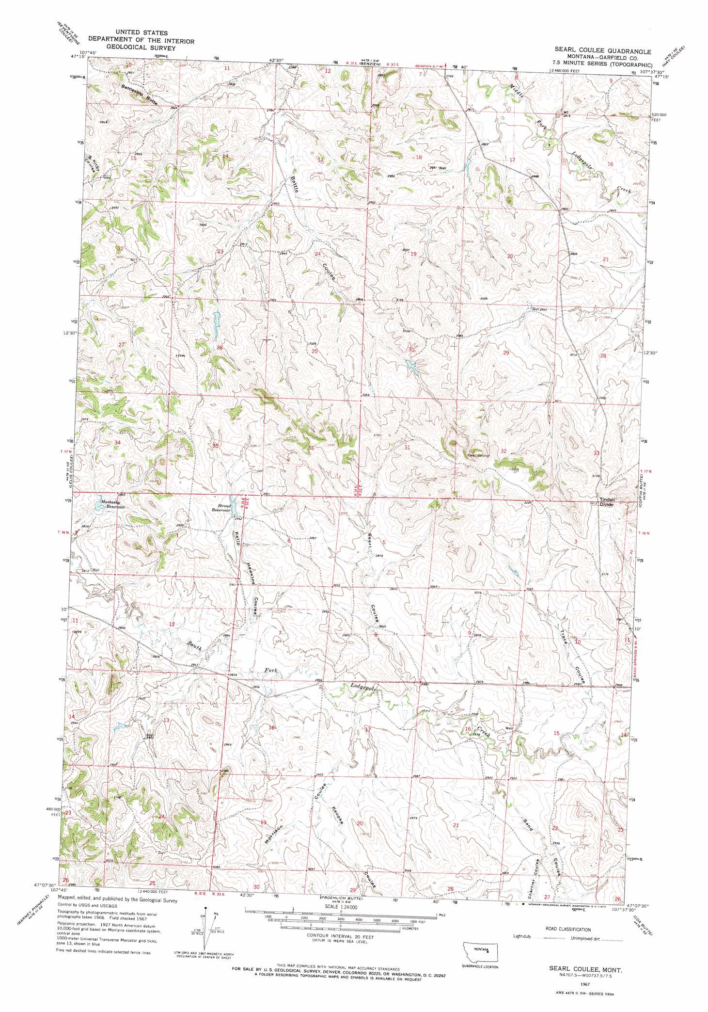
USGS Topo Quad 47107b6 - 1:24,000 scale
| Topo Map Name: | Searl Coulee |
| USGS Topo Quad ID: | 47107b6 |
| Print Size: | ca. 21 1/4" wide x 27" high |
| Southeast Coordinates: | 47.125° N latitude / 107.625° W longitude |
| Map Center Coordinates: | 47.1875° N latitude / 107.6875° W longitude |
| U.S. State: | MT |
| Filename: | o47107b6.jpg |
| Download Map JPG Image: | Searl Coulee topo map 1:24,000 scale |
| Map Type: | Topographic |
| Topo Series: | 7.5´ |
| Map Scale: | 1:24,000 |
| Source of Map Images: | United States Geological Survey (USGS) |
| Alternate Map Versions: |
Searl Coulee MT 1967, updated 1970 Download PDF Buy paper map Searl Coulee MT 2011 Download PDF Buy paper map Searl Coulee MT 2014 Download PDF Buy paper map |
1:24,000 Topo Quads surrounding Searl Coulee
Germaine Coulee West |
Germaine Coulee East |
Cap Rock Butte |
Spring Creek School |
Blackfoot School |
Nelson Coulee |
Seventynine Coulee |
Benzien |
Hay Coulee |
Steve Forks Sw |
Bridge Coulee |
Lelig Coulee |
Searl Coulee |
Coffin Butte |
Twin Buttes |
Fail Ranch |
Barney Pinnacle |
Froehlich Butte |
Cox Butte |
Sand Springs |
Mosby |
Hill Ranch |
Dutton Ranch |
Mcwilliams Springs |
Mcginnis Butte |
> Back to 47107a1 at 1:100,000 scale
> Back to 47106a1 at 1:250,000 scale
> Back to U.S. Topo Maps home
Searl Coulee topo map: Gazetteer
Searl Coulee: Dams
Brown Number 4 Dam elevation 899m 2949′Brown Number 5 Dam elevation 915m 3001′
Stroud Dam elevation 897m 2942′
Searl Coulee: Reservoirs
Mashesky Reservoir elevation 866m 2841′Stroud Reservoir elevation 888m 2913′
Searl Coulee: Summits
Battleship Butte elevation 925m 3034′Tindall Divide elevation 983m 3225′
Searl Coulee: Valleys
Chartier Coulee elevation 895m 2936′Kelly Hawkins Coulee elevation 866m 2841′
Koepke Coulee elevation 890m 2919′
Morrison Coulee elevation 876m 2874′
Sand Coulee elevation 888m 2913′
Searl Coulee elevation 880m 2887′
Trace Coulee elevation 896m 2939′
Searl Coulee: Wells
16N32E27ABDB01 Well elevation 906m 2972′Searl Coulee digital topo map on disk
Buy this Searl Coulee topo map showing relief, roads, GPS coordinates and other geographical features, as a high-resolution digital map file on DVD:
Eastern Montana & Western North Dakota
Buy digital topo maps: Eastern Montana & Western North Dakota