Bridge Coulee Topo Map Montana
To zoom in, hover over the map of Bridge Coulee
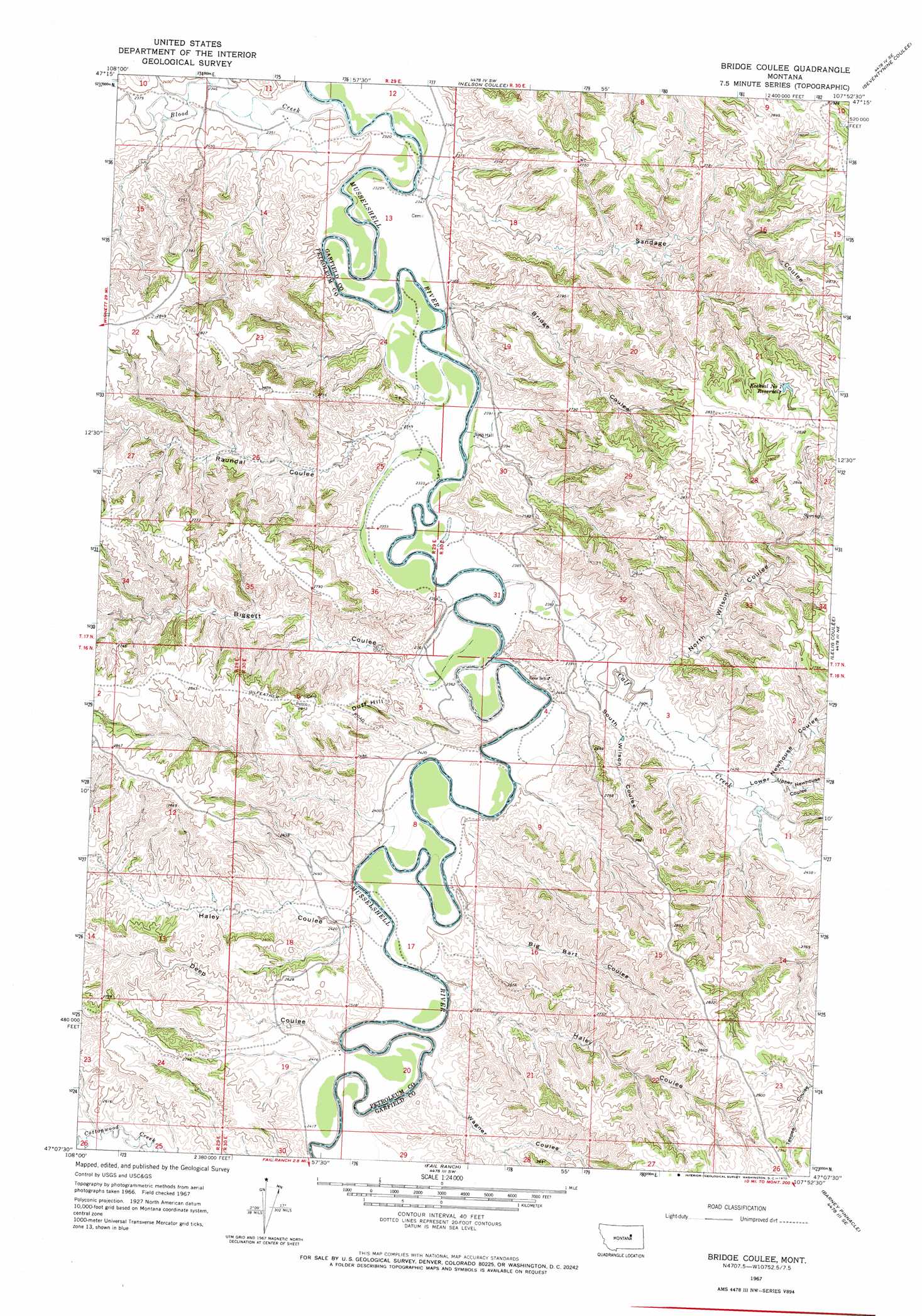
USGS Topo Quad 47107b8 - 1:24,000 scale
| Topo Map Name: | Bridge Coulee |
| USGS Topo Quad ID: | 47107b8 |
| Print Size: | ca. 21 1/4" wide x 27" high |
| Southeast Coordinates: | 47.125° N latitude / 107.875° W longitude |
| Map Center Coordinates: | 47.1875° N latitude / 107.9375° W longitude |
| U.S. State: | MT |
| Filename: | o47107b8.jpg |
| Download Map JPG Image: | Bridge Coulee topo map 1:24,000 scale |
| Map Type: | Topographic |
| Topo Series: | 7.5´ |
| Map Scale: | 1:24,000 |
| Source of Map Images: | United States Geological Survey (USGS) |
| Alternate Map Versions: |
Bridge Coulee MT 1967, updated 1970 Download PDF Buy paper map Bridge Coulee MT 2011 Download PDF Buy paper map Bridge Coulee MT 2014 Download PDF Buy paper map |
1:24,000 Topo Quads surrounding Bridge Coulee
Weingart Place Nw |
Weingart Place |
Germaine Coulee West |
Germaine Coulee East |
Cap Rock Butte |
Davis Spring |
Kirkendal Flat |
Nelson Coulee |
Seventynine Coulee |
Benzien |
Cat Creek Nw |
Tin Can Hill |
Bridge Coulee |
Lelig Coulee |
Searl Coulee |
Ingals Dam |
Cat Creek |
Fail Ranch |
Barney Pinnacle |
Froehlich Butte |
Petrolia Lake |
Breed Spring |
Mosby |
Hill Ranch |
Dutton Ranch |
> Back to 47107a1 at 1:100,000 scale
> Back to 47106a1 at 1:250,000 scale
> Back to U.S. Topo Maps home
Bridge Coulee topo map: Gazetteer
Bridge Coulee: Populated Places
Ross Hall elevation 721m 2365′Bridge Coulee: Post Offices
Ross Post Office (historical) elevation 725m 2378′Bridge Coulee: Reservoirs
Ezwkial Number One Reservoir elevation 857m 2811′Bridge Coulee: Streams
Blood Creek elevation 708m 2322′Calf Creek elevation 721m 2365′
Bridge Coulee: Summits
Duff Hill elevation 813m 2667′Bridge Coulee: Valleys
Big Bart Coulee elevation 732m 2401′Biggett Coulee elevation 730m 2395′
Bridge Coulee elevation 728m 2388′
Deep Coulee elevation 735m 2411′
Haley Coulee elevation 731m 2398′
Haley Coulee elevation 734m 2408′
Lower Newhouse Coulee elevation 745m 2444′
North Wilson Coulee elevation 743m 2437′
Raundal Coulee elevation 725m 2378′
Sandage Coulee elevation 722m 2368′
South Wilson Coulee elevation 735m 2411′
Upper Newhouse Coulee elevation 753m 2470′
Wagner Coulee elevation 729m 2391′
Bridge Coulee digital topo map on disk
Buy this Bridge Coulee topo map showing relief, roads, GPS coordinates and other geographical features, as a high-resolution digital map file on DVD:
Eastern Montana & Western North Dakota
Buy digital topo maps: Eastern Montana & Western North Dakota