Steve Forks Topo Map Montana
To zoom in, hover over the map of Steve Forks
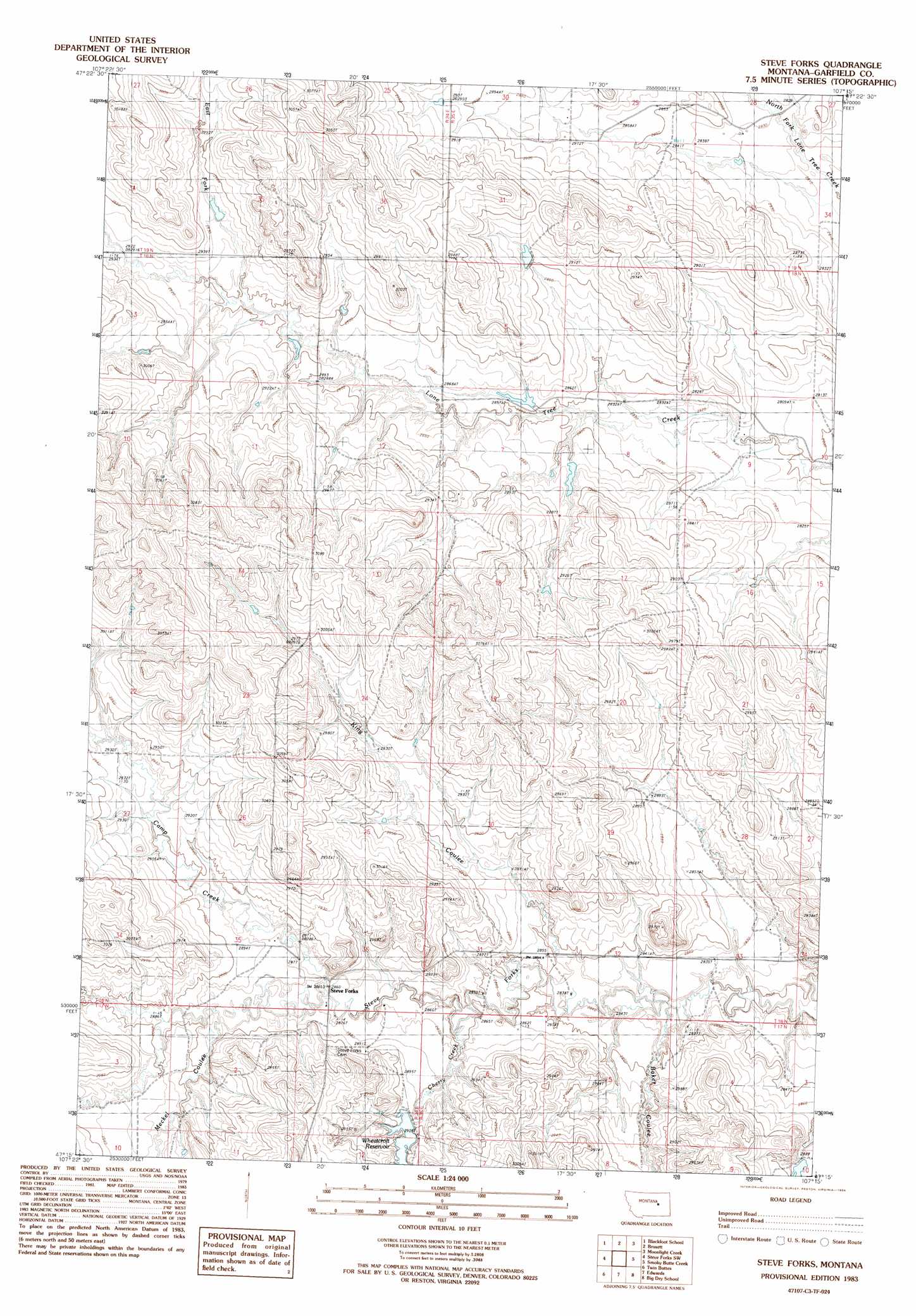
USGS Topo Quad 47107c3 - 1:24,000 scale
| Topo Map Name: | Steve Forks |
| USGS Topo Quad ID: | 47107c3 |
| Print Size: | ca. 21 1/4" wide x 27" high |
| Southeast Coordinates: | 47.25° N latitude / 107.25° W longitude |
| Map Center Coordinates: | 47.3125° N latitude / 107.3125° W longitude |
| U.S. State: | MT |
| Filename: | o47107c3.jpg |
| Download Map JPG Image: | Steve Forks topo map 1:24,000 scale |
| Map Type: | Topographic |
| Topo Series: | 7.5´ |
| Map Scale: | 1:24,000 |
| Source of Map Images: | United States Geological Survey (USGS) |
| Alternate Map Versions: |
Steve Forks MT 1983, updated 1984 Download PDF Buy paper map Steve Forks MT 2011 Download PDF Buy paper map Steve Forks MT 2014 Download PDF Buy paper map |
1:24,000 Topo Quads surrounding Steve Forks
Pine Grove School |
Sawmill Creek |
Chalk Butte |
Hell Hollow |
Trumbo Ranch |
Spring Creek School |
Blackfoot School |
Brusett |
Moonlight Creek |
Biscuit Butte |
Hay Coulee |
Steve Forks Sw |
Steve Forks |
Smoky Butte Creek |
Smoky Butte |
Coffin Butte |
Twin Buttes |
Edwards |
Big Dry School |
Ziegele |
Cox Butte |
Sand Springs |
Robertson School |
Van Dusen Spring |
Fig Mountain |
> Back to 47107a1 at 1:100,000 scale
> Back to 47106a1 at 1:250,000 scale
> Back to U.S. Topo Maps home
Steve Forks topo map: Gazetteer
Steve Forks: Dams
Get Down Dam elevation 882m 2893′Merlin Dam elevation 890m 2919′
Put It Together Dam elevation 884m 2900′
Waldo Number 2 Dam elevation 887m 2910′
Steve Forks: Populated Places
Steve Forks elevation 873m 2864′Steve Forks: Post Offices
Stevesfork Post Office (historical) elevation 906m 2972′Steve Forks: Reservoirs
Wheatcroft Reservoir elevation 879m 2883′Steve Forks: Streams
Camp Creek elevation 872m 2860′Cherry Creek elevation 871m 2857′
East Fork Lone Tree Creek elevation 882m 2893′
Steve Forks: Valleys
Baker Coulee elevation 867m 2844′King Coulee elevation 866m 2841′
Meckel Coulee elevation 882m 2893′
Steve Forks: Wells
18N34E24CC__01 Well elevation 906m 2972′Steve Forks digital topo map on disk
Buy this Steve Forks topo map showing relief, roads, GPS coordinates and other geographical features, as a high-resolution digital map file on DVD:
Eastern Montana & Western North Dakota
Buy digital topo maps: Eastern Montana & Western North Dakota