Lost Creek Topo Map Montana
To zoom in, hover over the map of Lost Creek
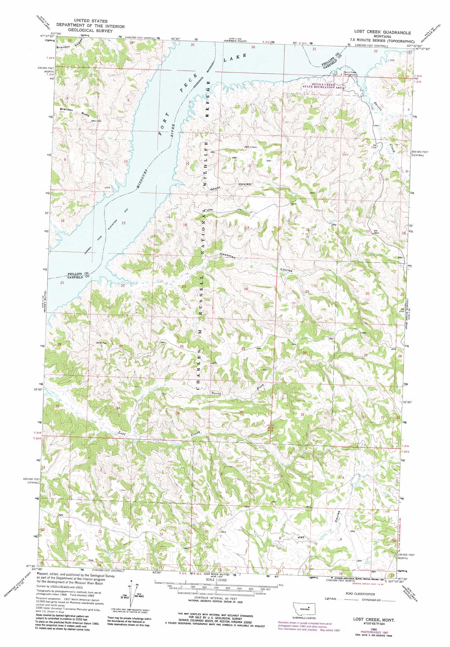
USGS Topo Quad 47107e6 - 1:24,000 scale
| Topo Map Name: | Lost Creek |
| USGS Topo Quad ID: | 47107e6 |
| Print Size: | ca. 21 1/4" wide x 27" high |
| Southeast Coordinates: | 47.5° N latitude / 107.625° W longitude |
| Map Center Coordinates: | 47.5625° N latitude / 107.6875° W longitude |
| U.S. State: | MT |
| Filename: | o47107e6.jpg |
| Download Map JPG Image: | Lost Creek topo map 1:24,000 scale |
| Map Type: | Topographic |
| Topo Series: | 7.5´ |
| Map Scale: | 1:24,000 |
| Source of Map Images: | United States Geological Survey (USGS) |
| Alternate Map Versions: |
Lost Creek MT 1965, updated 1969 Download PDF Buy paper map Lost Creek MT 1965, updated 1987 Download PDF Buy paper map Lost Creek MT 2011 Download PDF Buy paper map Lost Creek MT 2014 Download PDF Buy paper map |
1:24,000 Topo Quads surrounding Lost Creek
Dione Reservoir |
Stratton Reservoir |
Sun Prairie |
Coal Mine Hill |
Whiskey Coulee |
Pea Ridge |
Indian Lake |
Herman Point |
Schuyler Butte |
Swede Ridge |
Locke Ranch |
Mickey Butte |
Lost Creek |
Pine Grove School |
Sawmill Creek |
Germaine Coulee West |
Germaine Coulee East |
Cap Rock Butte |
Spring Creek School |
Blackfoot School |
Nelson Coulee |
Seventynine Coulee |
Benzien |
Hay Coulee |
Steve Forks Sw |
> Back to 47107e1 at 1:100,000 scale
> Back to 47106a1 at 1:250,000 scale
> Back to U.S. Topo Maps home
Lost Creek topo map: Gazetteer
Lost Creek: Dams
Bronze Dam elevation 878m 2880′Lost Creek: Parks
Devils Creek State Recreation Area elevation 695m 2280′Lost Creek: Streams
Deadman Coulee elevation 685m 2247′Devils Creek elevation 685m 2247′
Ghost Coulee elevation 685m 2247′
Lost Creek elevation 693m 2273′
North Fork Lost Creek elevation 717m 2352′
Lost Creek: Summits
Brandon Butte elevation 895m 2936′Lost Creek: Wells
24N31E34CC__01 Well elevation 855m 2805′Lost Creek digital topo map on disk
Buy this Lost Creek topo map showing relief, roads, GPS coordinates and other geographical features, as a high-resolution digital map file on DVD:
Eastern Montana & Western North Dakota
Buy digital topo maps: Eastern Montana & Western North Dakota