Whiskey Coulee Topo Map Montana
To zoom in, hover over the map of Whiskey Coulee
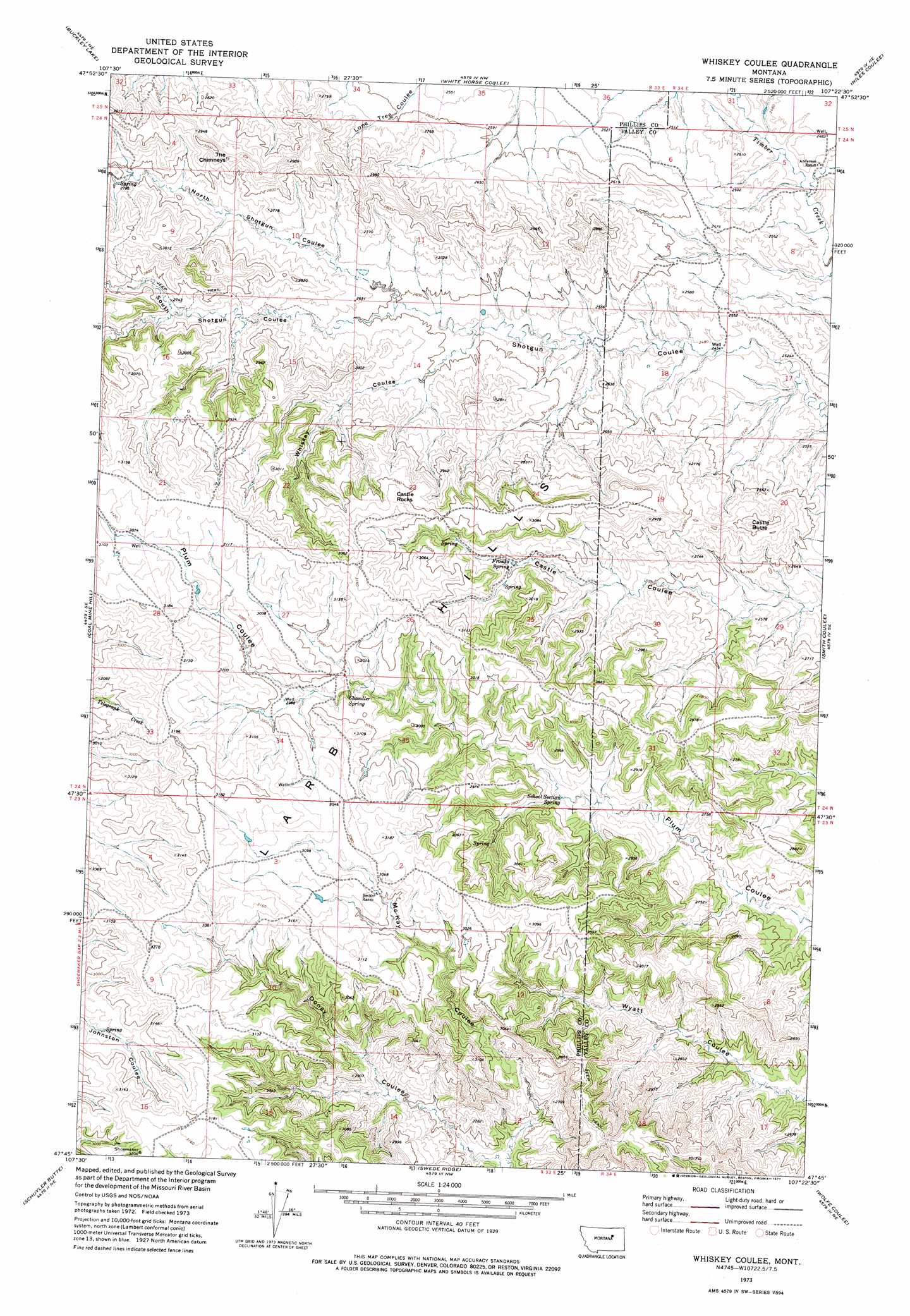
USGS Topo Quad 47107g4 - 1:24,000 scale
| Topo Map Name: | Whiskey Coulee |
| USGS Topo Quad ID: | 47107g4 |
| Print Size: | ca. 21 1/4" wide x 27" high |
| Southeast Coordinates: | 47.75° N latitude / 107.375° W longitude |
| Map Center Coordinates: | 47.8125° N latitude / 107.4375° W longitude |
| U.S. State: | MT |
| Filename: | o47107g4.jpg |
| Download Map JPG Image: | Whiskey Coulee topo map 1:24,000 scale |
| Map Type: | Topographic |
| Topo Series: | 7.5´ |
| Map Scale: | 1:24,000 |
| Source of Map Images: | United States Geological Survey (USGS) |
| Alternate Map Versions: |
Whiskey Coulee MT 1973, updated 1977 Download PDF Buy paper map Whiskey Coulee MT 2011 Download PDF Buy paper map Whiskey Coulee MT 2014 Download PDF Buy paper map |
1:24,000 Topo Quads surrounding Whiskey Coulee
Horse Pasture Coulee |
Content |
Harb Sw |
Craig Reservoir |
Burnett Flats West |
Sheep Coulee |
Buckley Lake |
White Horse Coulee |
Niles Coulee |
Triple Crossing Res. West |
Sun Prairie |
Coal Mine Hill |
Whiskey Coulee |
Smith Coulee |
Gibson Coulee |
Herman Point |
Schuyler Butte |
Swede Ridge |
Wolfe Coulee |
Wagon Coulee |
Lost Creek |
Pine Grove School |
Sawmill Creek |
Chalk Butte |
Hell Hollow |
> Back to 47107e1 at 1:100,000 scale
> Back to 47106a1 at 1:250,000 scale
> Back to U.S. Topo Maps home
Whiskey Coulee topo map: Gazetteer
Whiskey Coulee: Pillars
Castle Rocks elevation 930m 3051′The Chimneys elevation 915m 3001′
Whiskey Coulee: Springs
Chandler Spring elevation 895m 2936′Franks Spring elevation 850m 2788′
School Section Spring elevation 827m 2713′
Whiskey Coulee: Streams
Square Creek elevation 740m 2427′Whiskey Coulee: Summits
Castle Butte elevation 882m 2893′Whiskey Coulee: Valleys
Mc Kay Coulee elevation 764m 2506′North Shotgun Coulee elevation 793m 2601′
South Shotgun Coulee elevation 793m 2601′
Whiskey Coulee elevation 781m 2562′
Whiskey Coulee: Wells
24N34E18AD__01 Well elevation 758m 2486′Whiskey Coulee digital topo map on disk
Buy this Whiskey Coulee topo map showing relief, roads, GPS coordinates and other geographical features, as a high-resolution digital map file on DVD:
Eastern Montana & Western North Dakota
Buy digital topo maps: Eastern Montana & Western North Dakota