Sun Prairie Topo Map Montana
To zoom in, hover over the map of Sun Prairie
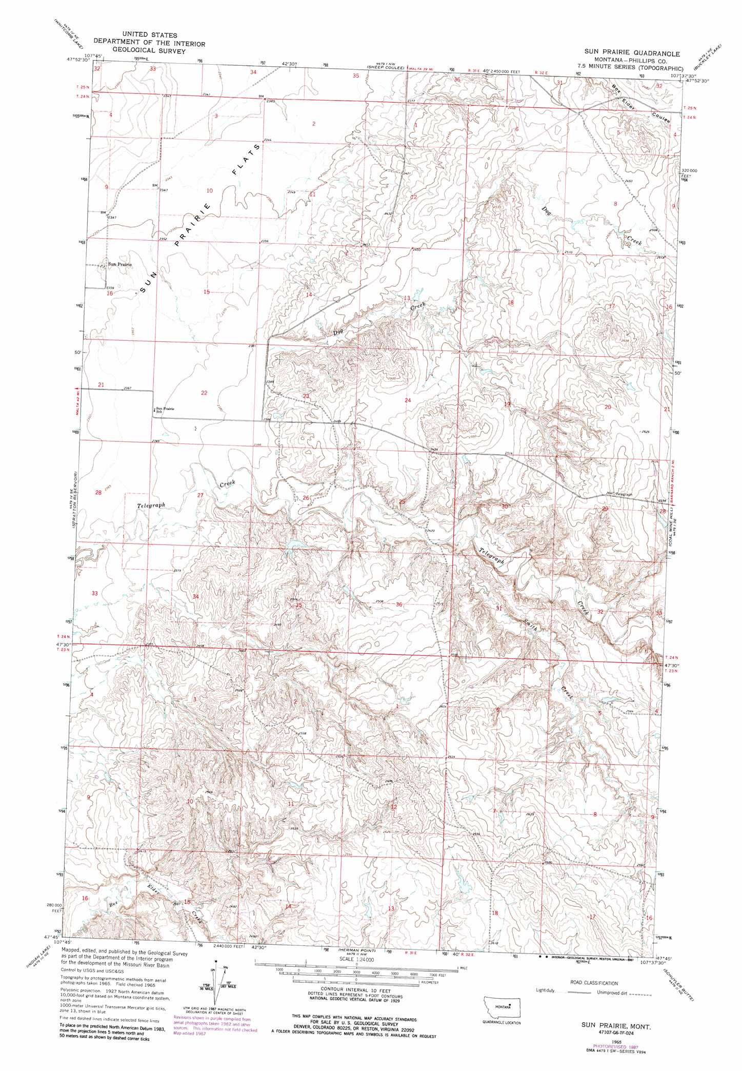
USGS Topo Quad 47107g6 - 1:24,000 scale
| Topo Map Name: | Sun Prairie |
| USGS Topo Quad ID: | 47107g6 |
| Print Size: | ca. 21 1/4" wide x 27" high |
| Southeast Coordinates: | 47.75° N latitude / 107.625° W longitude |
| Map Center Coordinates: | 47.8125° N latitude / 107.6875° W longitude |
| U.S. State: | MT |
| Filename: | o47107g6.jpg |
| Download Map JPG Image: | Sun Prairie topo map 1:24,000 scale |
| Map Type: | Topographic |
| Topo Series: | 7.5´ |
| Map Scale: | 1:24,000 |
| Source of Map Images: | United States Geological Survey (USGS) |
| Alternate Map Versions: |
Sun Prairie MT 1965, updated 1969 Download PDF Buy paper map Sun Prairie MT 1965, updated 1987 Download PDF Buy paper map Sun Prairie MT 1965, updated 1987 Download PDF Buy paper map Sun Prairie MT 2011 Download PDF Buy paper map Sun Prairie MT 2014 Download PDF Buy paper map |
1:24,000 Topo Quads surrounding Sun Prairie
Button Butte |
Mitchell Corner |
Horse Pasture Coulee |
Content |
Harb Sw |
Emond Ranch |
Whitcomb Lake |
Sheep Coulee |
Buckley Lake |
White Horse Coulee |
Dione Reservoir |
Stratton Reservoir |
Sun Prairie |
Coal Mine Hill |
Whiskey Coulee |
Pea Ridge |
Indian Lake |
Herman Point |
Schuyler Butte |
Swede Ridge |
Locke Ranch |
Mickey Butte |
Lost Creek |
Pine Grove School |
Sawmill Creek |
> Back to 47107e1 at 1:100,000 scale
> Back to 47106a1 at 1:250,000 scale
> Back to U.S. Topo Maps home
Sun Prairie topo map: Gazetteer
Sun Prairie: Dams
Koss Number 2 Dam elevation 742m 2434′Sun Prairie: Populated Places
Sun Prairie elevation 723m 2372′Sun Prairie: Post Offices
Sun Prairie Post Office (historical) elevation 724m 2375′Telegraph Creek Post Office (historical) elevation 779m 2555′
Sun Prairie: Streams
Dog Creek elevation 729m 2391′Smith Creek elevation 742m 2434′
Sun Prairie: Wells
23N31E11CA__01 Well elevation 773m 2536′24N31E11AA__01 Well elevation 722m 2368′
24N31E15ACC_01 Well elevation 721m 2365′
Sun Prairie digital topo map on disk
Buy this Sun Prairie topo map showing relief, roads, GPS coordinates and other geographical features, as a high-resolution digital map file on DVD:
Eastern Montana & Western North Dakota
Buy digital topo maps: Eastern Montana & Western North Dakota