Dione Reservoir Topo Map Montana
To zoom in, hover over the map of Dione Reservoir
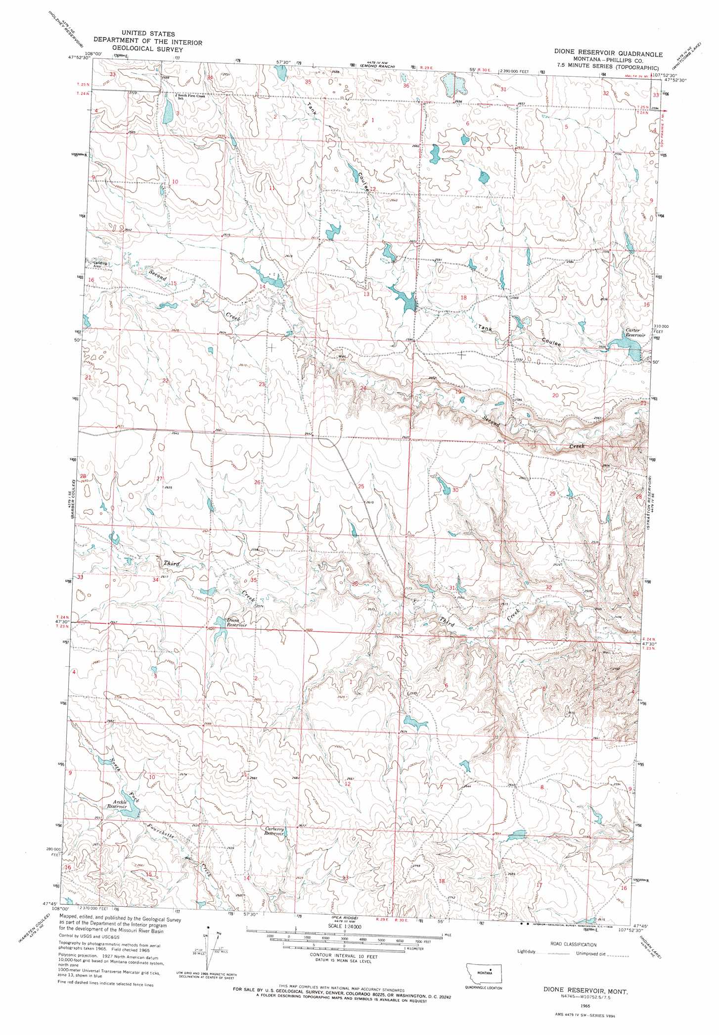
USGS Topo Quad 47107g8 - 1:24,000 scale
| Topo Map Name: | Dione Reservoir |
| USGS Topo Quad ID: | 47107g8 |
| Print Size: | ca. 21 1/4" wide x 27" high |
| Southeast Coordinates: | 47.75° N latitude / 107.875° W longitude |
| Map Center Coordinates: | 47.8125° N latitude / 107.9375° W longitude |
| U.S. State: | MT |
| Filename: | o47107g8.jpg |
| Download Map JPG Image: | Dione Reservoir topo map 1:24,000 scale |
| Map Type: | Topographic |
| Topo Series: | 7.5´ |
| Map Scale: | 1:24,000 |
| Source of Map Images: | United States Geological Survey (USGS) |
| Alternate Map Versions: |
Dione Reservoir MT 1965, updated 1969 Download PDF Buy paper map Dione Reservoir MT 2011 Download PDF Buy paper map Dione Reservoir MT 2014 Download PDF Buy paper map |
1:24,000 Topo Quads surrounding Dione Reservoir
Phillips |
Seymour Reservoir |
Button Butte |
Mitchell Corner |
Horse Pasture Coulee |
Veseth Reservoir |
Holzhey Reservoir |
Emond Ranch |
Whitcomb Lake |
Sheep Coulee |
Dry Fork Ridge |
Barber Coulee |
Dione Reservoir |
Stratton Reservoir |
Sun Prairie |
Lake Reservoir |
Karsten Coulee |
Pea Ridge |
Indian Lake |
Herman Point |
Dry Coulee |
Chain Buttes |
Locke Ranch |
Mickey Butte |
Lost Creek |
> Back to 47107e1 at 1:100,000 scale
> Back to 47106a1 at 1:250,000 scale
> Back to U.S. Topo Maps home
Dione Reservoir topo map: Gazetteer
Dione Reservoir: Dams
Blunt Ranch Number 3 Dam elevation 804m 2637′Blunt RanchES Number 2 Dam elevation 804m 2637′
Carberry Dam elevation 811m 2660′
Carters Reservoir Dam elevation 765m 2509′
Curly Q Dam elevation 815m 2673′
Dione Reservoir Dam elevation 795m 2608′
Fifty Dam elevation 803m 2634′
Veseth and Veseth Number 1 Dam elevation 797m 2614′
Veseth and Veseth Number 2 Dam elevation 792m 2598′
Dione Reservoir: Populated Places
First Creek (historical) elevation 790m 2591′Dione Reservoir: Post Offices
First Creek Post Office (historical) elevation 790m 2591′Dione Reservoir: Reservoirs
Archie Reservoir elevation 803m 2634′Carberry Reservoir elevation 808m 2650′
Carter Reservoir elevation 763m 2503′
Dione Reservoir elevation 797m 2614′
Dione Reservoir: Wells
23N29E15AD__01 Well elevation 799m 2621′24N29E14CBD_01 Well elevation 793m 2601′
24N29E14DA__01 Well elevation 798m 2618′
24N29E24BA__01 Well elevation 794m 2604′
24N30E21BAC_01 Well elevation 763m 2503′
24N30E32DADA01 Well elevation 747m 2450′
25N29E33DDAD01 Well elevation 821m 2693′
Dione Reservoir digital topo map on disk
Buy this Dione Reservoir topo map showing relief, roads, GPS coordinates and other geographical features, as a high-resolution digital map file on DVD:
Eastern Montana & Western North Dakota
Buy digital topo maps: Eastern Montana & Western North Dakota