Mitchell Crossing Topo Map Montana
To zoom in, hover over the map of Mitchell Crossing
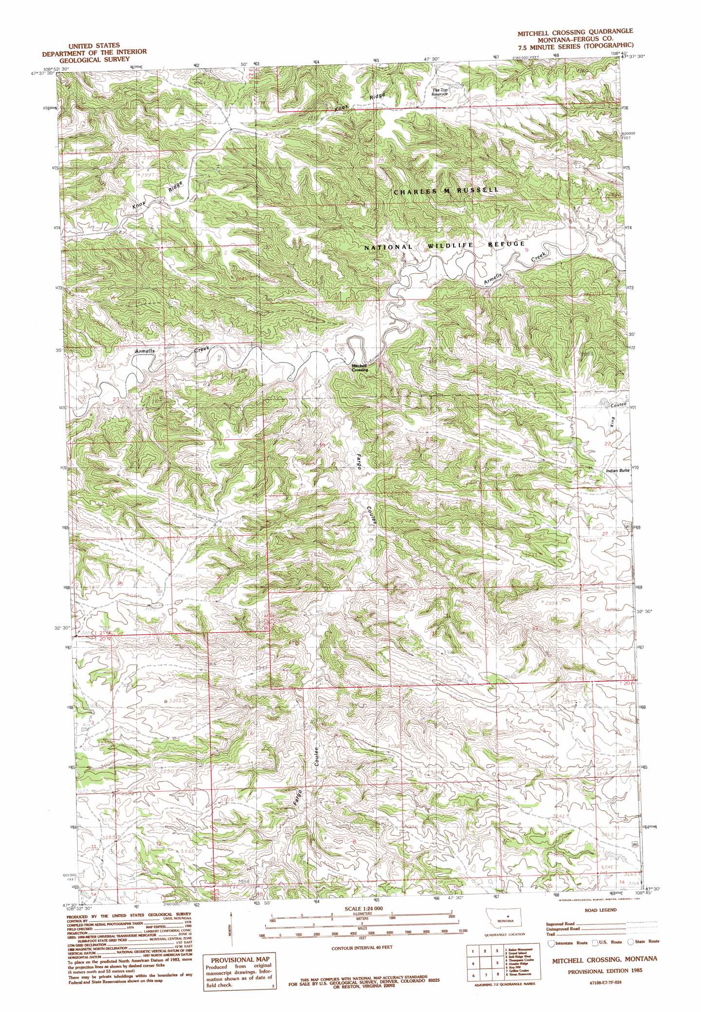
USGS Topo Quad 47108e7 - 1:24,000 scale
| Topo Map Name: | Mitchell Crossing |
| USGS Topo Quad ID: | 47108e7 |
| Print Size: | ca. 21 1/4" wide x 27" high |
| Southeast Coordinates: | 47.5° N latitude / 108.75° W longitude |
| Map Center Coordinates: | 47.5625° N latitude / 108.8125° W longitude |
| U.S. State: | MT |
| Filename: | o47108e7.jpg |
| Download Map JPG Image: | Mitchell Crossing topo map 1:24,000 scale |
| Map Type: | Topographic |
| Topo Series: | 7.5´ |
| Map Scale: | 1:24,000 |
| Source of Map Images: | United States Geological Survey (USGS) |
| Alternate Map Versions: |
Mitchell Crossing MT 1985, updated 1985 Download PDF Buy paper map Mitchell Crossing MT 2011 Download PDF Buy paper map Mitchell Crossing MT 2014 Download PDF Buy paper map |
1:24,000 Topo Quads surrounding Mitchell Crossing
Sturgeon Island |
Cow Island |
Shetland Divide |
D Y Junction |
Hays Se |
Reppe Butte |
Baker Monument |
Grand Island |
Bell Ridge West |
Bell Ridge East |
Bakers Spring |
Thompson Coulee |
Mitchell Crossing |
Hessler Ridge |
Carter Coulee |
Fergus Ne |
Roy Nw |
Griffee Coulee |
Sloan Reservoir |
Kachia Reservoir |
Fergus |
Roy |
Bohemian Corners |
Bear Creek Reservoir |
Bear Creek Reservoir Se |
> Back to 47108e1 at 1:100,000 scale
> Back to 47108a1 at 1:250,000 scale
> Back to U.S. Topo Maps home
Mitchell Crossing topo map: Gazetteer
Mitchell Crossing: Post Offices
Bundane Post Office (historical) elevation 927m 3041′Mitchell Crossing: Reservoirs
Flat Top Reservoir elevation 881m 2890′Mitchell Crossing: Ridges
Knox Ridge elevation 877m 2877′Mitchell Crossing: Summits
Indian Butte elevation 928m 3044′Mitchell Crossing: Valleys
Fargo Coulee elevation 740m 2427′Mitchell Crossing: Wells
20N23E03AA__01 Well elevation 903m 2962′20N23E03ADCC01 Well elevation 917m 3008′
20N23E04CC__01 Well elevation 907m 2975′
21N23E18DA__01 Well elevation 734m 2408′
21N23E22CDCC01 Well elevation 925m 3034′
Mitchell Crossing digital topo map on disk
Buy this Mitchell Crossing topo map showing relief, roads, GPS coordinates and other geographical features, as a high-resolution digital map file on DVD: