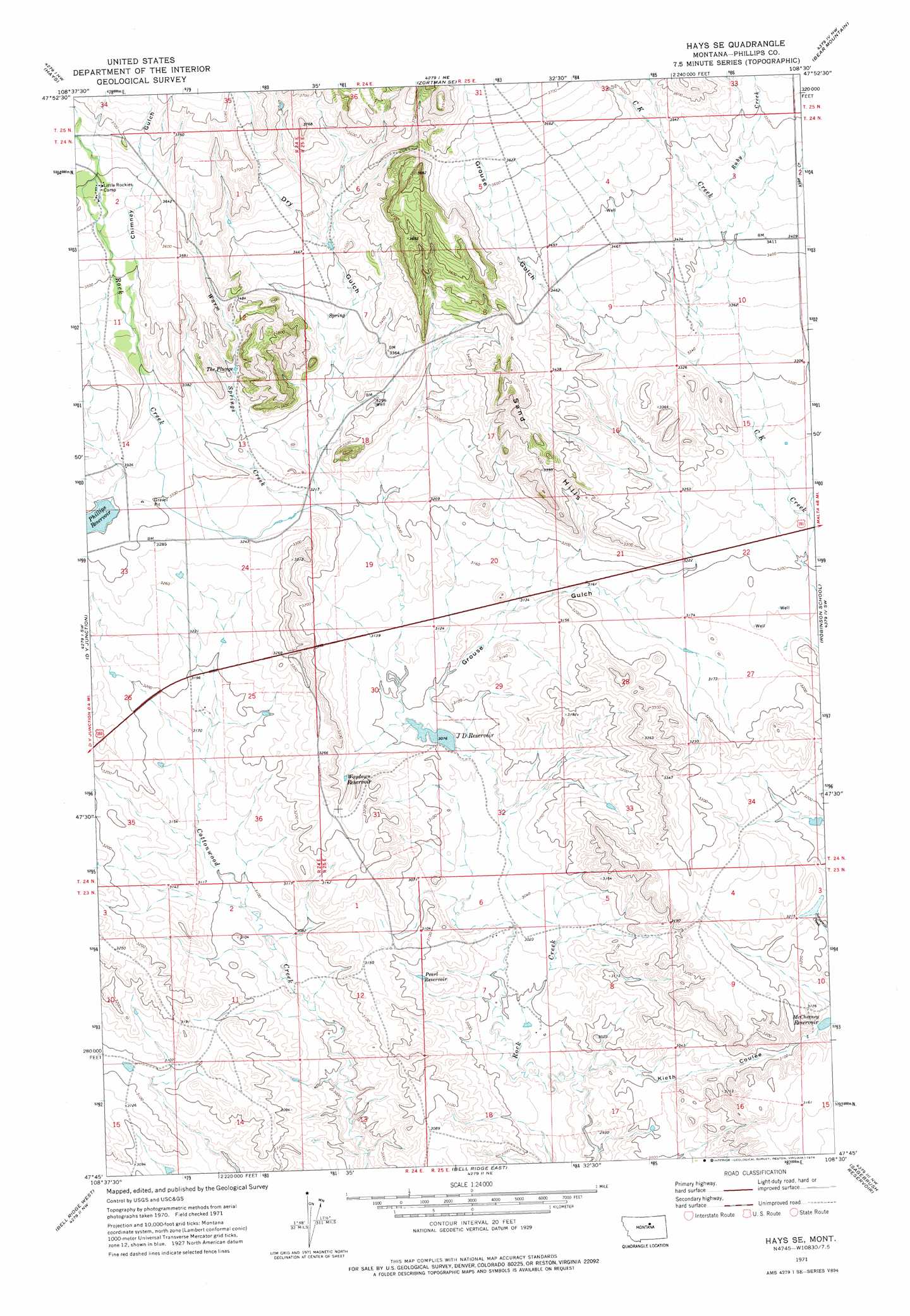
Hays Se Topo Map Montana
To zoom in, hover over the map of Hays Se
USGS Topo Quad 47108g5 - 1:24,000 scale
| Topo Map Name: | Hays Se |
| USGS Topo Quad ID: | 47108g5 |
| Print Size: | ca. 21 1/4" wide x 27" high |
| Southeast Coordinates: | 47.75° N latitude / 108.5° W longitude |
| Map Center Coordinates: | 47.8125° N latitude / 108.5625° W longitude |
| U.S. State: | MT |
| Filename: | o47108g5.jpg |
| Download Map JPG Image: | Hays Se topo map 1:24,000 scale |
| Map Type: | Topographic |
| Topo Series: | 7.5´ |
| Map Scale: | 1:24,000 |
| Source of Map Images: | United States Geological Survey (USGS) |
| Alternate Map Versions: |
Hays SE MT 1971, updated 1974 Download PDF Buy paper map Hays SE MT 2011 Download PDF Buy paper map Hays SE MT 2014 Download PDF Buy paper map |
1:24,000 Topo Quads surrounding Hays Se
Lake Seventeen East |
Stiffarm Coulee |
Lodge Pole |
Ball Coulee |
Ester Lake |
Crazyman Coulee |
Hays |
Zortman |
Bear Mountain |
Coburn Butte |
Shetland Divide |
D Y Junction |
Hays Se |
Robinson School |
Bison Bone Reservoir |
Grand Island |
Bell Ridge West |
Bell Ridge East |
Sagebrush Reservoir |
Blizzard Reservoir |
Mitchell Crossing |
Hessler Ridge |
Carter Coulee |
Kepple Bottoms |
Hanson Flat |
> Back to 47108e1 at 1:100,000 scale
> Back to 47108a1 at 1:250,000 scale
> Back to U.S. Topo Maps home
Hays Se topo map: Gazetteer
Hays Se: Dams
Lazy J-D Number 1 Dam elevation 939m 3080′McChesney Reservoir Dam elevation 954m 3129′
Hays Se: Lakes
The Plunge elevation 1031m 3382′Hays Se: Parks
Little Rocky Mountains Historical Marker elevation 980m 3215′Hays Se: Reservoirs
J D Reservoir elevation 938m 3077′McChesney Reservoir elevation 952m 3123′
Pearl Reservoir elevation 933m 3061′
Waydown Reservoir elevation 965m 3166′
Hays Se: Ridges
Sand Hills elevation 1043m 3421′Hays Se: Springs
24N24E12CDDA01 Spring elevation 1032m 3385′Hays Se: Streams
Ruby Creek elevation 971m 3185′Warm Springs Creek elevation 978m 3208′
Whitmore Spring Creek elevation 976m 3202′
Hays Se: Valleys
Chimney Gulch elevation 1054m 3458′Dry Gulch elevation 945m 3100′
Grouse Gulch elevation 942m 3090′
Kieth Coulee elevation 959m 3146′
Hays Se: Wells
24N24E25CB__01 Well elevation 970m 3182′24N24E25CBC_01 Well elevation 971m 3185′
Hays Se digital topo map on disk
Buy this Hays Se topo map showing relief, roads, GPS coordinates and other geographical features, as a high-resolution digital map file on DVD: