Lewistown Topo Map Montana
To zoom in, hover over the map of Lewistown
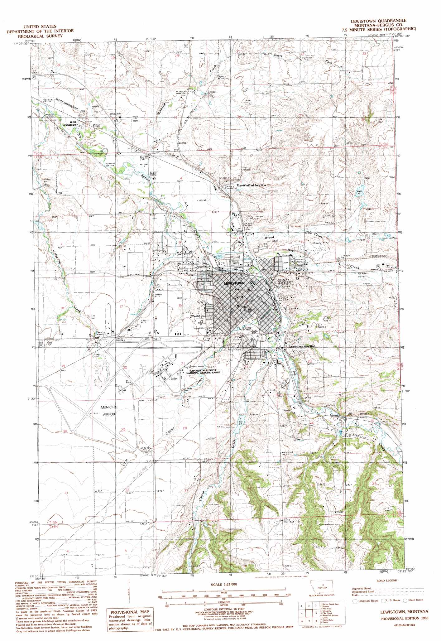
USGS Topo Quad 47109a4 - 1:24,000 scale
| Topo Map Name: | Lewistown |
| USGS Topo Quad ID: | 47109a4 |
| Print Size: | ca. 21 1/4" wide x 27" high |
| Southeast Coordinates: | 47° N latitude / 109.375° W longitude |
| Map Center Coordinates: | 47.0625° N latitude / 109.4375° W longitude |
| U.S. State: | MT |
| Filename: | o47109a4.jpg |
| Download Map JPG Image: | Lewistown topo map 1:24,000 scale |
| Map Type: | Topographic |
| Topo Series: | 7.5´ |
| Map Scale: | 1:24,000 |
| Source of Map Images: | United States Geological Survey (USGS) |
| Alternate Map Versions: |
Lewistown MT 1985, updated 1986 Download PDF Buy paper map Lewistown MT 2011 Download PDF Buy paper map Lewistown MT 2014 Download PDF Buy paper map |
1:24,000 Topo Quads surrounding Lewistown
Toney Bench |
Seventytwo Hills |
Kendall |
Hilger |
Armells |
Danvers |
Spring Creek Junction |
Brooks |
New Year |
Judith Peak |
Ross Fork |
Glengarry |
Lewistown |
Pike Creek |
Horsethief Coulee W. |
Moore |
West Fork Beaver Creek |
Castle Butte |
Heath |
Loco Ridge |
Moore Sw |
Crystal Lake |
Jump Off Peak |
Half Moon Canyon |
Alaska Bench |
> Back to 47109a1 at 1:100,000 scale
> Back to 47108a1 at 1:250,000 scale
> Back to U.S. Topo Maps home
Lewistown topo map: Gazetteer
Lewistown: Airports
Central Montana Hospital and Nursing Home Heliport elevation 1246m 4087′Gillett Landing Strip elevation 1157m 3795′
Lewistown Municipal Airport elevation 1267m 4156′
Lewistown: Bridges
Big Spring Creek Bridge elevation 1197m 3927′Chicago Milwaukee Saint Paul and Pacific Overpass Bridge elevation 1253m 4110′
Lewistown: Dams
Big Casino Creek Dam elevation 1257m 4124′Butcher Dam elevation 1199m 3933′
Puppie Tail Dam elevation 1250m 4101′
Lewistown: Parks
D'Autremont Complex elevation 1261m 4137′Fergus Athletic Field elevation 1211m 3973′
Frank Day Park elevation 1203m 3946′
Fred Robinson Park elevation 1220m 4002′
Hawthorne Park elevation 1194m 3917′
Jaycees Park elevation 1210m 3969′
Judith Basin Country Historical Marker elevation 1239m 4064′
Judith Park elevation 1190m 3904′
Kiwanis Park elevation 1203m 3946′
Lewistown Historical Marker elevation 1221m 4005′
Mill Ditch Park elevation 1197m 3927′
Symmes Park elevation 1205m 3953′
Lewistown: Populated Places
Akerville (historical) elevation 1199m 3933′Lewistown elevation 1203m 3946′
Lewistown Heights elevation 1203m 3946′
Lewistown Junction elevation 1202m 3943′
Mountain Acres Mobile Home Park elevation 1191m 3907′
Roy-Winifred Junction elevation 1190m 3904′
Sawyers Trailer Park elevation 1203m 3946′
Valley View Castle Mobile Home Park elevation 1196m 3923′
West Lewistown elevation 1169m 3835′
Lewistown: Post Offices
Lewistown Post Office elevation 1195m 3920′Reedsfort Post Office (historical) elevation 1204m 3950′
Lewistown: Streams
Boyd Creek elevation 1196m 3923′Breed Creek elevation 1195m 3920′
Burnette Creek elevation 1180m 3871′
Casino Creek elevation 1206m 3956′
Little Casino Creek elevation 1204m 3950′
South Fork Burnette Creek elevation 1199m 3933′
Wolverine Creek elevation 1146m 3759′
Lewistown: Wells
14N18E01DBAD01 Well elevation 1361m 4465′14N18E04DBB_01 Well elevation 1309m 4294′
15N17E31ACBD01 Well elevation 1287m 4222′
15N18E04DCCA01 Well elevation 1179m 3868′
15N18E05ADAA01 Well elevation 1170m 3838′
15N18E05ADAA02 Well elevation 1169m 3835′
15N18E07DDBC01 Well elevation 1237m 4058′
15N18E09BBAB01 Well elevation 1193m 3914′
15N18E09CADA01 Well elevation 1206m 3956′
15N18E09CBC_01 Well elevation 1236m 4055′
15N18E09CCAA01 Well elevation 1226m 4022′
15N18E09CD__01 Well elevation 1214m 3982′
15N18E09DBAD01 Well elevation 1201m 3940′
15N18E10BAA_01 Well elevation 1195m 3920′
15N18E11AACC01 Well elevation 1212m 3976′
15N18E11DCB_01 Well elevation 1213m 3979′
15N18E12CBAA01 Well elevation 1240m 4068′
15N18E13AAC_01 Well elevation 1235m 4051′
15N18E14CD__01 Well elevation 1245m 4084′
15N18E14CDAD01 Well elevation 1250m 4101′
15N18E14DB__01 Well elevation 1237m 4058′
15N18E15ADD_01 Well elevation 1200m 3937′
15N18E15BBBA01 Well elevation 1204m 3950′
15N18E16AB__01 Well elevation 1223m 4012′
15N18E16CCC_01 Well elevation 1257m 4124′
15N18E16CDD_01 Well elevation 1255m 4117′
15N18E16DCCC01 Well elevation 1254m 4114′
15N18E16DDBB01 Well elevation 1248m 4094′
15N18E16DDBC01 Well elevation 1251m 4104′
15N18E17AAB_01 Well elevation 1233m 4045′
15N18E18DCC_01 Well elevation 1255m 4117′
15N18E20AAAB01 Well elevation 1259m 4130′
15N18E22ADDA01 Well elevation 1220m 4002′
15N18E22BAA_01 Well elevation 1220m 4002′
15N18E22BBBB01 Well elevation 1237m 4058′
15N18E22BBBC01 Well elevation 1238m 4061′
15N18E22BDDA01 Well elevation 1239m 4064′
15N18E22CCC_01 Well elevation 1263m 4143′
15N18E23BAB_01 Well elevation 1223m 4012′
15N18E23BABB01 Well elevation 1220m 4002′
15N18E23BDBC01 Well elevation 1233m 4045′
15N18E23BDCA01 Well elevation 1251m 4104′
15N18E23BDCD01 Well elevation 1252m 4107′
15N18E25ADC_01 Well elevation 1260m 4133′
15N18E25CBCB01 Well elevation 1258m 4127′
15N18E25CBCB02 Well elevation 1258m 4127′
15N18E26CCBA01 Well elevation 1308m 4291′
15N18E26CCDA01 Well elevation 1299m 4261′
15N18E26CCDC01 Well elevation 1306m 4284′
15N18E26DB__01 Well elevation 1246m 4087′
15N18E26DBBA01 Well elevation 1237m 4058′
15N18E27AA__01 Well elevation 1275m 4183′
15N18E27BBBB01 Well elevation 1264m 4146′
15N18E33ACA_01 Well elevation 1283m 4209′
15N18E33ACAB01 Well elevation 1276m 4186′
15N18E33ACBB01 Well elevation 1281m 4202′
15N18E33DCDC01 Well elevation 1267m 4156′
15N18E35AABA01 Well elevation 1290m 4232′
16N18E32DCB_01 Well elevation 1169m 3835′
16N18E32DCD_01 Well elevation 1169m 3835′
16N18E33ACAD01 Well elevation 1198m 3930′
16N18E33ACAD02 Well elevation 1198m 3930′
16N18E33CCB_01 Well elevation 1189m 3900′
Lewistown digital topo map on disk
Buy this Lewistown topo map showing relief, roads, GPS coordinates and other geographical features, as a high-resolution digital map file on DVD: