Judith Peak Topo Map Montana
To zoom in, hover over the map of Judith Peak
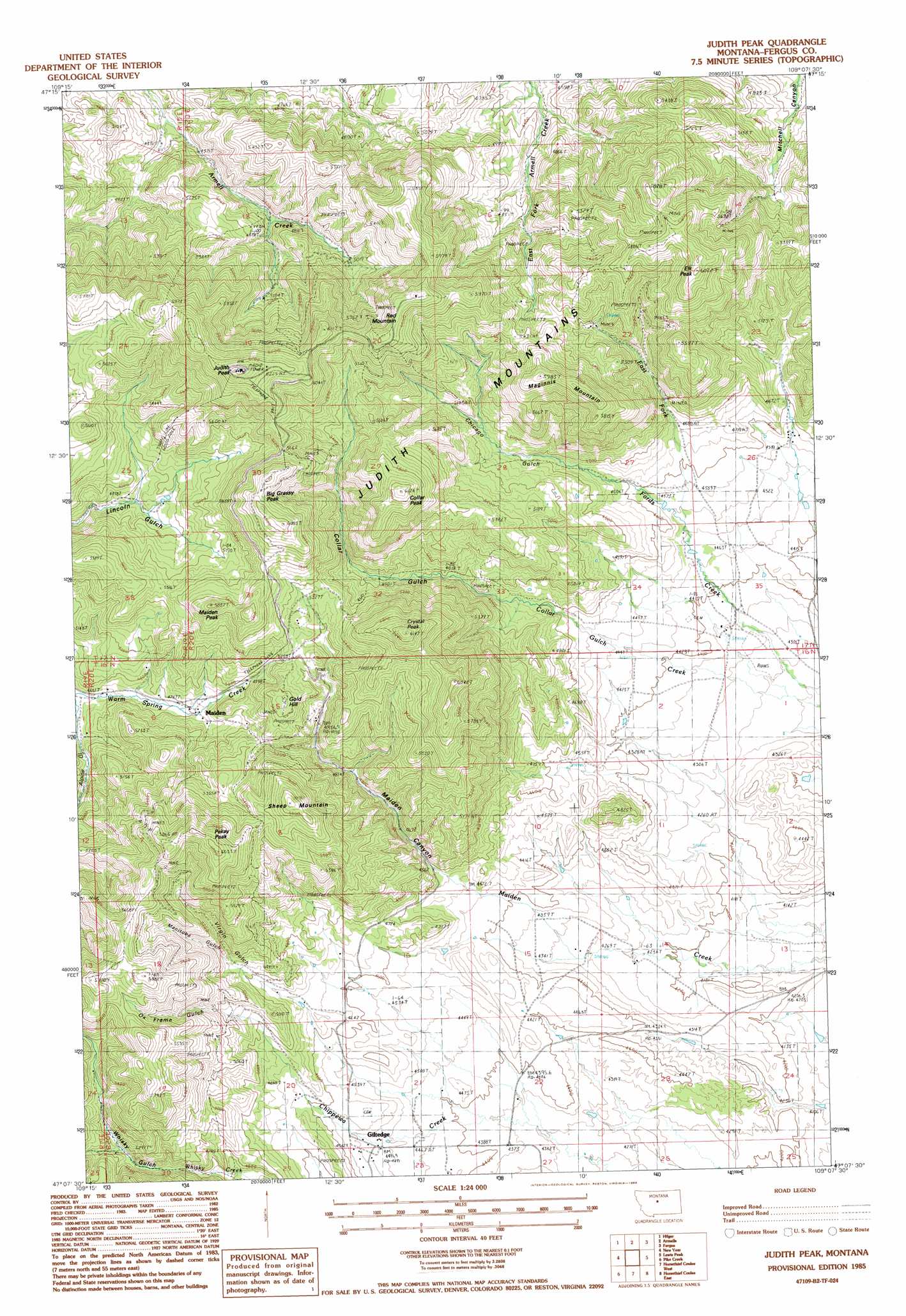
USGS Topo Quad 47109b2 - 1:24,000 scale
| Topo Map Name: | Judith Peak |
| USGS Topo Quad ID: | 47109b2 |
| Print Size: | ca. 21 1/4" wide x 27" high |
| Southeast Coordinates: | 47.125° N latitude / 109.125° W longitude |
| Map Center Coordinates: | 47.1875° N latitude / 109.1875° W longitude |
| U.S. State: | MT |
| Filename: | o47109b2.jpg |
| Download Map JPG Image: | Judith Peak topo map 1:24,000 scale |
| Map Type: | Topographic |
| Topo Series: | 7.5´ |
| Map Scale: | 1:24,000 |
| Source of Map Images: | United States Geological Survey (USGS) |
| Alternate Map Versions: |
Judith Peak MT 1985, updated 1986 Download PDF Buy paper map Judith Peak MT 2011 Download PDF Buy paper map Judith Peak MT 2014 Download PDF Buy paper map |
1:24,000 Topo Quads surrounding Judith Peak
Hilger Nw |
Christina |
The Horse Ranch |
Fergus Ne |
Roy Nw |
Kendall |
Hilger |
Armells |
Fergus |
Roy |
Brooks |
New Year |
Judith Peak |
Lewis Peak |
Grass Range Nw |
Lewistown |
Pike Creek |
Horsethief Coulee W. |
Horsethief Coulee E. |
Fish Dam |
Castle Butte |
Heath |
Loco Ridge |
Forestgrove |
Becket |
> Back to 47109a1 at 1:100,000 scale
> Back to 47108a1 at 1:250,000 scale
> Back to U.S. Topo Maps home
Judith Peak topo map: Gazetteer
Judith Peak: Mines
Armell Creek Number 1 Mine elevation 1488m 4881′Black Bull Mine elevation 1672m 5485′
Black Bull Mine elevation 1715m 5626′
Cumberland Mine elevation 1548m 5078′
East Fork Armell Creek Number 1 Mine elevation 1558m 5111′
East Fork Armell Creek Number 2 Mine elevation 1552m 5091′
East Fork Armell Creek Number 3 Mine elevation 1770m 5807′
East Fork Creek Number 1 Mine elevation 1695m 5561′
East Fork Creek Number 2 Mine elevation 1628m 5341′
East Fork Creek Number 3 Mine elevation 1622m 5321′
East Fork Number 4 Mine elevation 1468m 4816′
East Fork Number 5 Mine elevation 1487m 4878′
East Fork Number 6 Mine elevation 1640m 5380′
Elk Peak Number 1 Mine elevation 1587m 5206′
Elk Peak Number 2 Mine elevation 1604m 5262′
Elk Peak Number 3 Mine elevation 1566m 5137′
Elk Peak Number 4 Mine elevation 1613m 5291′
Elk Peak Number 5 Mine elevation 1622m 5321′
Elk Peak Number 6 Mine elevation 1622m 5321′
Elk Peak Number 7 Mine elevation 1611m 5285′
Gilt Edge Mine elevation 1539m 5049′
Giltedge Mine elevation 1512m 4960′
Justice Mine elevation 1511m 4957′
Lower Old Glory Mine elevation 1540m 5052′
Lower Old Nelson Mine elevation 1557m 5108′
Lower Ox Frame Gulch Mine elevation 1639m 5377′
Maginnis Mine elevation 1555m 5101′
Miranda Mine elevation 1581m 5187′
Old Glory Mine elevation 1650m 5413′
Old Glory Mine elevation 1680m 5511′
Pekay Peak Number 1 Mine elevation 1597m 5239′
Pekay Peak Number 2 Mine elevation 1549m 5082′
Red Mountain Mine elevation 1755m 5757′
Spotted Horse Mine elevation 1647m 5403′
Spotted Horse Mine elevation 1523m 4996′
Tail Holt Mine elevation 1710m 5610′
Tail Holt Mine elevation 1732m 5682′
Uper Ox Frame Gulch Mine elevation 1672m 5485′
Upper Old Nelson Mine elevation 1557m 5108′
Verde Mine elevation 1898m 6227′
Virgin Gulch Number 1 Mine elevation 1596m 5236′
War Eagle Mine elevation 1707m 5600′
Judith Peak: Populated Places
Canyon (historical) elevation 1522m 4993′Giltedge elevation 1377m 4517′
Maiden elevation 1474m 4835′
Rustle (historical) elevation 1627m 5337′
Judith Peak: Post Offices
Giltedge Post Office (historical) elevation 1372m 4501′Maiden Post Office (historical) elevation 1463m 4799′
Judith Peak: Ranges
Judith Mountains elevation 1834m 6017′Judith Peak: Springs
17N20E19AC__01 Spring elevation 1666m 5465′Judith Peak: Streams
East Fork Fords Creek elevation 1366m 4481′Judith Peak: Summits
Big Grassy Peak elevation 1798m 5898′Collar Peak elevation 1818m 5964′
Crystal Peak elevation 1811m 5941′
Elk Peak elevation 1804m 5918′
Gold Hill elevation 1649m 5410′
Judith Peak elevation 1918m 6292′
Maginnis Mountain elevation 1771m 5810′
Maiden Peak elevation 1713m 5620′
Pekay Peak elevation 1828m 5997′
Red Mountain elevation 1866m 6122′
Sheep Mountain elevation 1780m 5839′
Judith Peak: Valleys
Alpine Gulch elevation 1415m 4642′Chicago Gulch elevation 1370m 4494′
Collar Gulch elevation 1379m 4524′
Maiden Canyon elevation 1354m 4442′
Manitoba Gulch elevation 1481m 4858′
Ox Frame Gulch elevation 1378m 4520′
Virgin Gulch elevation 1387m 4550′
Judith Peak: Wells
16N20E06ADCC01 Well elevation 1464m 4803′Judith Peak digital topo map on disk
Buy this Judith Peak topo map showing relief, roads, GPS coordinates and other geographical features, as a high-resolution digital map file on DVD: