New Year Topo Map Montana
To zoom in, hover over the map of New Year
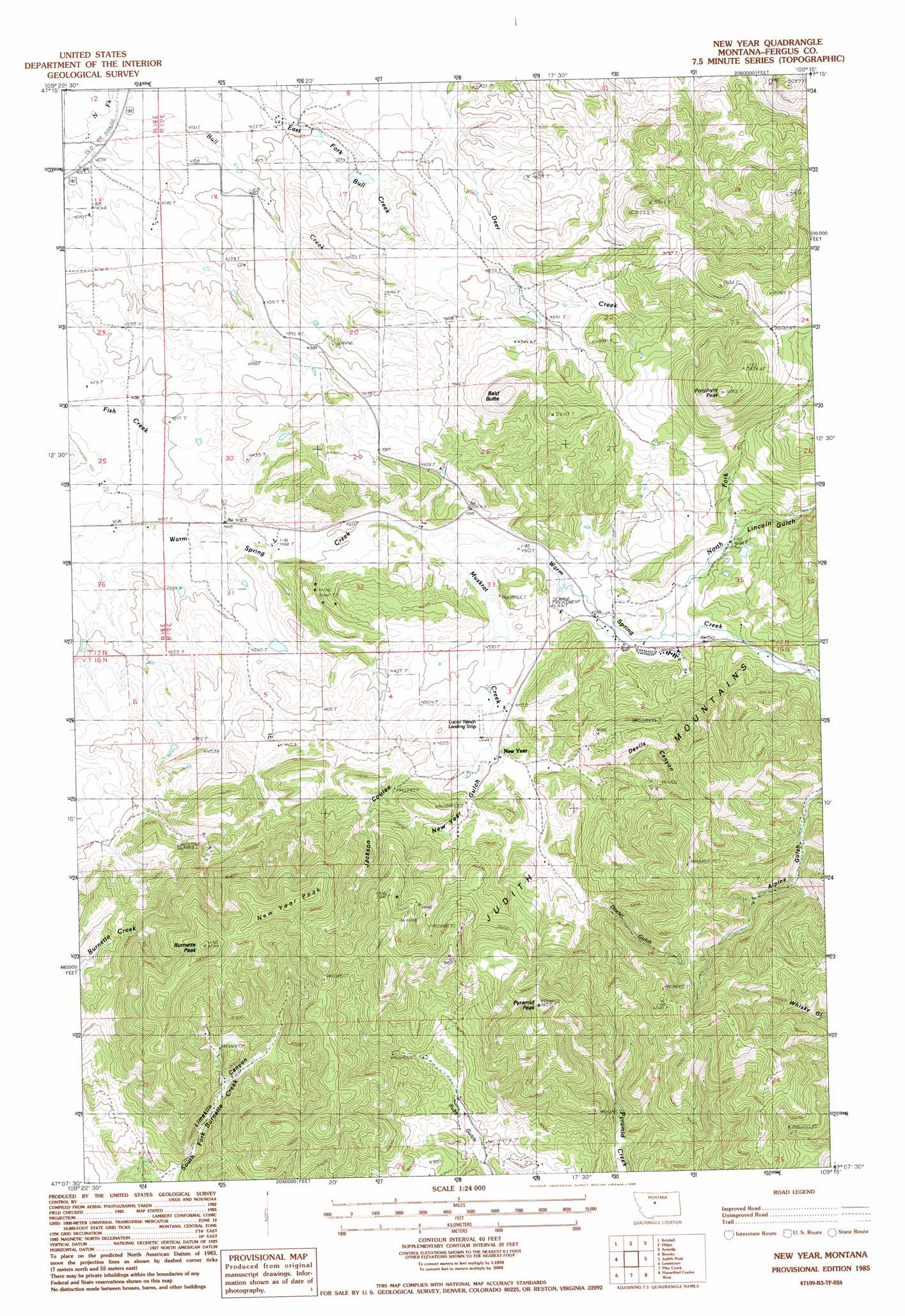
USGS Topo Quad 47109b3 - 1:24,000 scale
| Topo Map Name: | New Year |
| USGS Topo Quad ID: | 47109b3 |
| Print Size: | ca. 21 1/4" wide x 27" high |
| Southeast Coordinates: | 47.125° N latitude / 109.25° W longitude |
| Map Center Coordinates: | 47.1875° N latitude / 109.3125° W longitude |
| U.S. State: | MT |
| Filename: | o47109b3.jpg |
| Download Map JPG Image: | New Year topo map 1:24,000 scale |
| Map Type: | Topographic |
| Topo Series: | 7.5´ |
| Map Scale: | 1:24,000 |
| Source of Map Images: | United States Geological Survey (USGS) |
| Alternate Map Versions: |
New Year MT 1985, updated 1986 Download PDF Buy paper map New Year MT 2011 Download PDF Buy paper map New Year MT 2014 Download PDF Buy paper map |
1:24,000 Topo Quads surrounding New Year
Wild Bill Flat East |
Hilger Nw |
Christina |
The Horse Ranch |
Fergus Ne |
Seventytwo Hills |
Kendall |
Hilger |
Armells |
Fergus |
Spring Creek Junction |
Brooks |
New Year |
Judith Peak |
Lewis Peak |
Glengarry |
Lewistown |
Pike Creek |
Horsethief Coulee W. |
Horsethief Coulee E. |
West Fork Beaver Creek |
Castle Butte |
Heath |
Loco Ridge |
Forestgrove |
> Back to 47109a1 at 1:100,000 scale
> Back to 47108a1 at 1:250,000 scale
> Back to U.S. Topo Maps home
New Year topo map: Gazetteer
New Year: Airports
Lucier Ranch Landing Strip elevation 1351m 4432′New Year: Dams
Limpke Number 2 Dam elevation 1395m 4576′New Year: Mines
Devils Canyon Number 1 Mine elevation 1553m 5095′Devils Canyon Number 2 Mine elevation 1507m 4944′
Limekiln Canyon Mine elevation 1458m 4783′
Lower New Year Mine elevation 1617m 5305′
New Year East Number 1 Mine elevation 1611m 5285′
New Year East Number 2 Mine elevation 1655m 5429′
New Year Gulch Mine elevation 1687m 5534′
New Year Mine elevation 1581m 5187′
New Year Mine elevation 1720m 5643′
New Year Subsidence Mine elevation 1720m 5643′
Pyramid Creek Mine elevation 1536m 5039′
Ruby Gulch Mine elevation 1581m 5187′
Western Mines elevation 1615m 5298′
Western Mines Number 1 Mine elevation 1446m 4744′
Western Mines Number 2 Mine elevation 1600m 5249′
Western Mines Number 3 Mine elevation 1661m 5449′
Western Mines Number 4 Mine elevation 1597m 5239′
New Year: Populated Places
Andersonville (historical) elevation 1346m 4416′New Year elevation 1467m 4812′
New Year: Post Offices
Andersonville Post Office (historical) elevation 1346m 4416′New Year Post Office (historical) elevation 1467m 4812′
New Year: Streams
Bull Creek elevation 1390m 4560′East Fork Bull Creek elevation 1231m 4038′
Muskrat Creek elevation 1301m 4268′
North Fork Warm Spring Creek elevation 1361m 4465′
New Year: Summits
Bald Butte elevation 1558m 5111′Burnette Peak elevation 1777m 5830′
New Year Peak elevation 1792m 5879′
Porphyry Peak elevation 1828m 5997′
Pyramid Peak elevation 1839m 6033′
New Year: Valleys
Devils Canyon elevation 1419m 4655′Dexter Gulch elevation 1386m 4547′
Jackson Coulee elevation 1354m 4442′
Lincoln Gulch elevation 1428m 4685′
New Year Gulch elevation 1374m 4507′
New Year: Wells
16N19E02A___01 Well elevation 1402m 4599′16N19E10BCDB01 Well elevation 1398m 4586′
16N19E10CCBB01 Well elevation 1449m 4753′
16N19E10DDBC01 Well elevation 1437m 4714′
17N19E34CBAA01 Well elevation 1337m 4386′
17N19E34CCBD01 Well elevation 1381m 4530′
New Year digital topo map on disk
Buy this New Year topo map showing relief, roads, GPS coordinates and other geographical features, as a high-resolution digital map file on DVD: