The Horse Ranch Topo Map Montana
To zoom in, hover over the map of The Horse Ranch
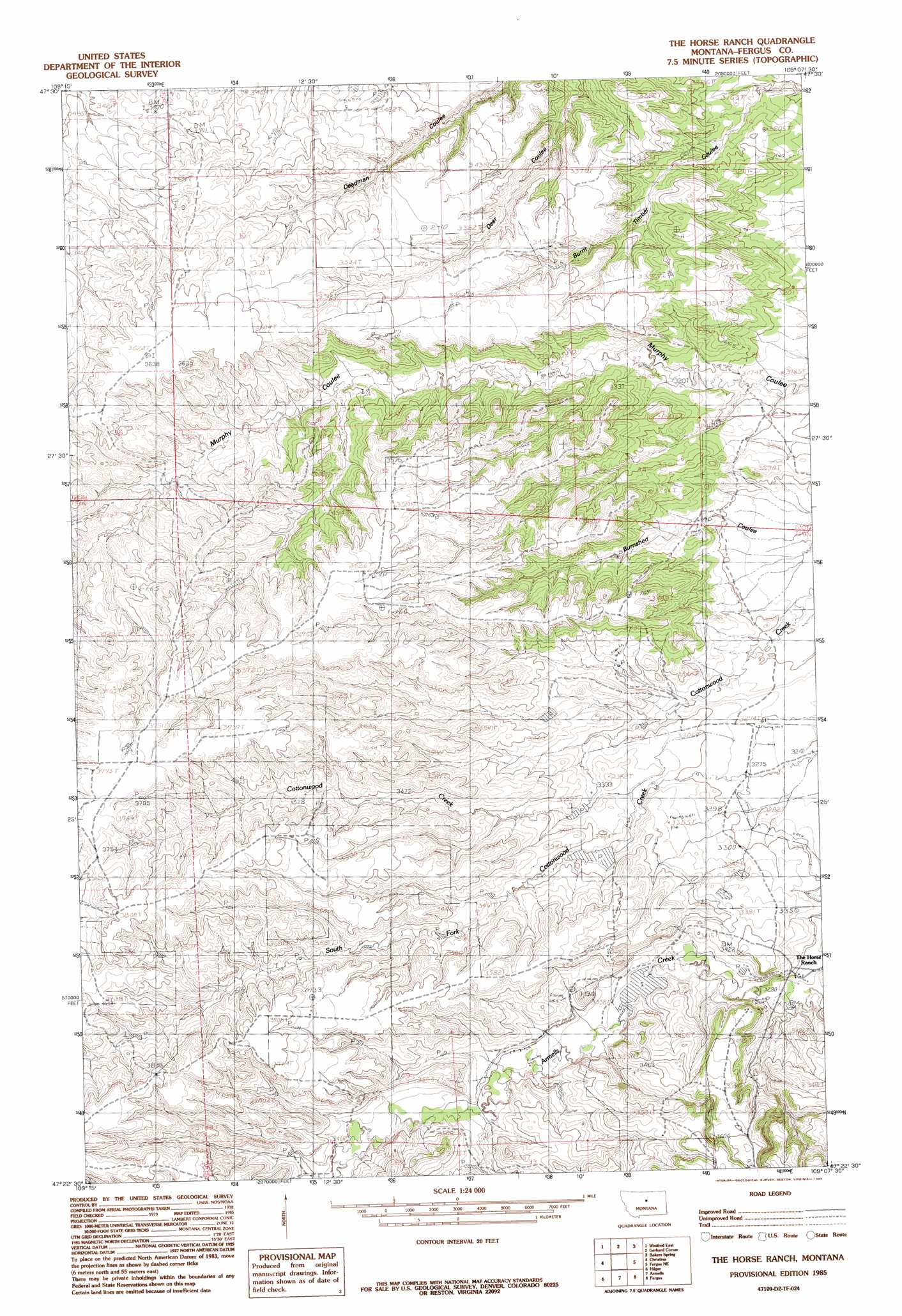
USGS Topo Quad 47109d2 - 1:24,000 scale
| Topo Map Name: | The Horse Ranch |
| USGS Topo Quad ID: | 47109d2 |
| Print Size: | ca. 21 1/4" wide x 27" high |
| Southeast Coordinates: | 47.375° N latitude / 109.125° W longitude |
| Map Center Coordinates: | 47.4375° N latitude / 109.1875° W longitude |
| U.S. State: | MT |
| Filename: | o47109d2.jpg |
| Download Map JPG Image: | The Horse Ranch topo map 1:24,000 scale |
| Map Type: | Topographic |
| Topo Series: | 7.5´ |
| Map Scale: | 1:24,000 |
| Source of Map Images: | United States Geological Survey (USGS) |
| Alternate Map Versions: |
The Horse Ranch MT 1985, updated 1985 Download PDF Buy paper map The Horse Ranch MT 2011 Download PDF Buy paper map The Horse Ranch MT 2014 Download PDF Buy paper map |
1:24,000 Topo Quads surrounding The Horse Ranch
Gallatin Rapids |
Taffy Ridge |
Woodhawk Hill |
Reppe Butte |
Baker Monument |
Winifred West |
Winifred East |
Gerhard Corner |
Bakers Spring |
Thompson Coulee |
Hilger Nw |
Christina |
The Horse Ranch |
Fergus Ne |
Roy Nw |
Kendall |
Hilger |
Armells |
Fergus |
Roy |
Brooks |
New Year |
Judith Peak |
Lewis Peak |
Grass Range Nw |
> Back to 47109a1 at 1:100,000 scale
> Back to 47108a1 at 1:250,000 scale
> Back to U.S. Topo Maps home
The Horse Ranch topo map: Gazetteer
The Horse Ranch: Dams
Armells Reservoir Dam elevation 1025m 3362′Taylor Fish Dam elevation 1004m 3293′
Taylor Reservoir Dam elevation 1040m 3412′
The Horse Ranch: Valleys
Deer Coulee elevation 974m 3195′The Horse Ranch: Wells
19N20E10BC__01 Well elevation 1021m 3349′19N20E11BCC_01 Well elevation 987m 3238′
19N20E15AC__01 Well elevation 1029m 3375′
19N20E23BC__01 Well elevation 1007m 3303′
19N20E23BCB_01 Well elevation 1036m 3398′
19N20E23CD__01 Well elevation 1061m 3480′
19N20E23DB__01 Well elevation 1005m 3297′
19N20E26BD__01 Well elevation 1055m 3461′
20N20E17DCBB01 Well elevation 1041m 3415′
The Horse Ranch digital topo map on disk
Buy this The Horse Ranch topo map showing relief, roads, GPS coordinates and other geographical features, as a high-resolution digital map file on DVD: