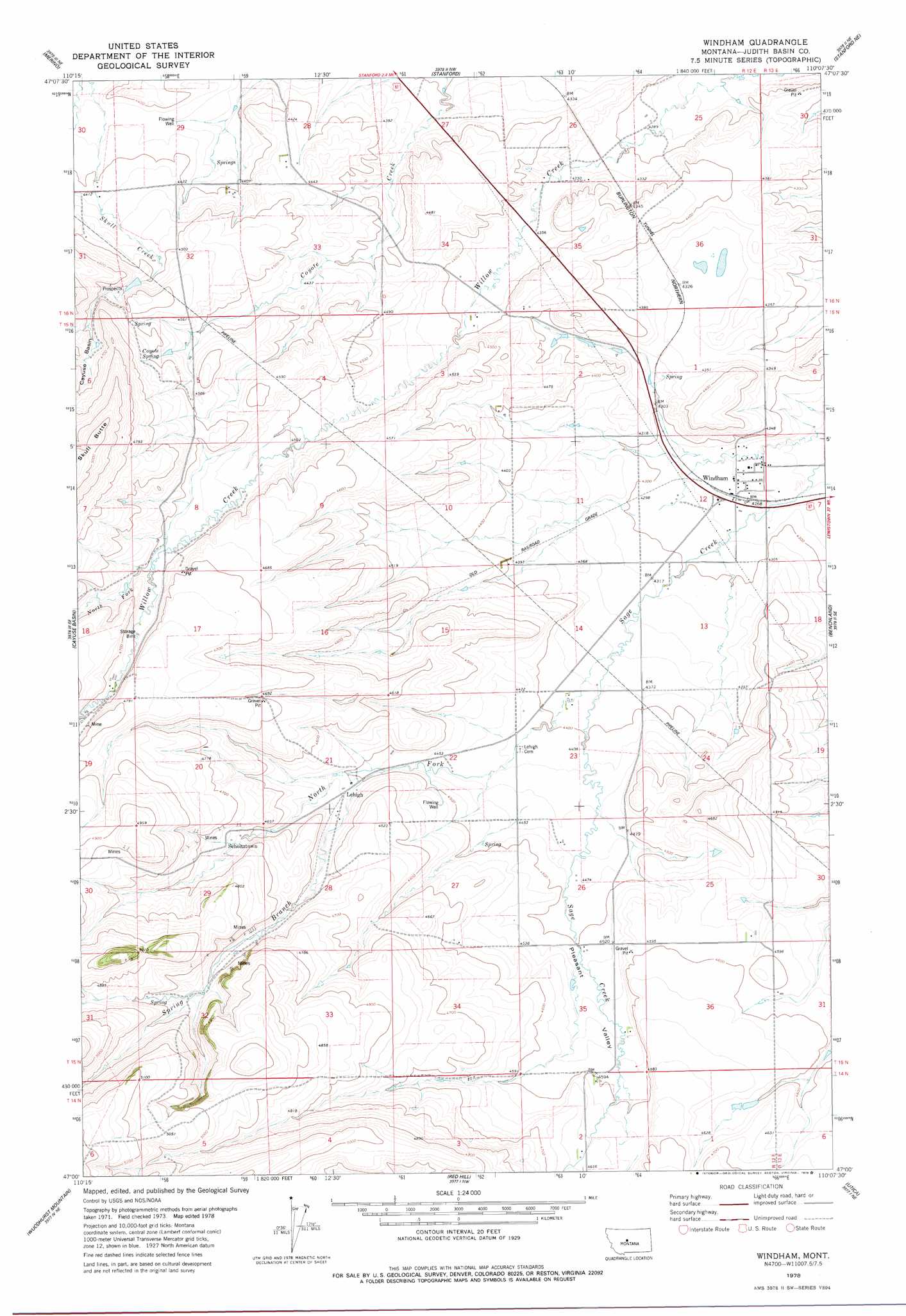
Windham Topo Map Montana
To zoom in, hover over the map of Windham
USGS Topo Quad 47110a2 - 1:24,000 scale
| Topo Map Name: | Windham |
| USGS Topo Quad ID: | 47110a2 |
| Print Size: | ca. 21 1/4" wide x 27" high |
| Southeast Coordinates: | 47° N latitude / 110.125° W longitude |
| Map Center Coordinates: | 47.0625° N latitude / 110.1875° W longitude |
| U.S. State: | MT |
| Filename: | o47110a2.jpg |
| Download Map JPG Image: | Windham topo map 1:24,000 scale |
| Map Type: | Topographic |
| Topo Series: | 7.5´ |
| Map Scale: | 1:24,000 |
| Source of Map Images: | United States Geological Survey (USGS) |
| Alternate Map Versions: |
Windham MT 1978, updated 1979 Download PDF Buy paper map Windham MT 2011 Download PDF Buy paper map Windham MT 2014 Download PDF Buy paper map |
1:24,000 Topo Quads surrounding Windham
Geyser |
Leiberg Coulee |
Arrow Creek |
Coffee Creek |
Denton |
Wolf Butte Nw |
Merino |
Stanford |
Stanford Ne |
Big Spring |
Wolf Butte |
Cayuse Basin |
Windham |
Benchland |
Moccasin |
Band Box Mountain |
Woodhurst Mountain |
Red Hill |
Utica |
Ackley Lake |
Ettien Spring |
Indian Hill |
Browns Canyon |
Twin Sisters |
Martin Coulee |
> Back to 47110a1 at 1:100,000 scale
> Back to 47110a1 at 1:250,000 scale
> Back to U.S. Topo Maps home
Windham topo map: Gazetteer
Windham: Populated Places
Lehigh elevation 1379m 4524′Scholtztown elevation 1416m 4645′
Windham elevation 1300m 4265′
Windham: Post Offices
Lehigh Post Office (historical) elevation 1379m 4524′Sifton Post Office (historical) elevation 1334m 4376′
Windham Post Office (historical) elevation 1300m 4265′
Windham: Springs
14N12E01AC__01 Spring elevation 1414m 4639′14N12E02AB__02 Spring elevation 1409m 4622′
14N12E02AD__01 Spring elevation 1409m 4622′
14N12E03BA__01 Spring elevation 1454m 4770′
14N12E03BA__02 Spring elevation 1454m 4770′
14N12E04AA__01 Spring elevation 1468m 4816′
14N12E04AB__01 Spring elevation 1463m 4799′
14N12E05BB__01 Spring elevation 1535m 5036′
14N12E05CB__01 Spring elevation 1549m 5082′
14N13E06BC__01 Spring elevation 1409m 4622′
15N12E05BB__01 Spring elevation 1403m 4603′
15N12E05BC__01 Spring elevation 1415m 4642′
15N12E05BC__02 Spring elevation 1431m 4694′
15N12E06DB__01 Spring elevation 1443m 4734′
15N12E10CB__01 Spring elevation 1362m 4468′
15N12E11CC__01 Spring elevation 1336m 4383′
15N12E15BA__01 Spring elevation 1365m 4478′
15N12E20DB__01 Spring elevation 1438m 4717′
15N12E23BB__01 Spring elevation 1347m 4419′
15N12E23DB__01 Spring elevation 1350m 4429′
15N12E25CB__01 Spring elevation 1399m 4589′
15N12E25DA__01 Spring elevation 1391m 4563′
15N12E26AA__01 Spring elevation 1362m 4468′
15N12E28CA__01 Spring elevation 1429m 4688′
15N12E30DA__01 Spring elevation 1467m 4812′
15N12E32BC__01 Spring elevation 1490m 4888′
15N12E32BD__01 Spring elevation 1451m 4760′
15N12E32CD__01 Spring elevation 1528m 5013′
15N12E33AB__01 Spring elevation 1444m 4737′
15N12E34BA__01 Spring elevation 1435m 4708′
15N12E35BD__01 Spring elevation 1395m 4576′
15N12E35CA__01 Spring elevation 1397m 4583′
16N12E35CB__01 Spring elevation 1345m 4412′
Coyote Spring elevation 1415m 4642′
Windham: Streams
North Fork Sage Creek elevation 1329m 4360′North Fork Willow Creek elevation 1403m 4603′
Spring Branch elevation 1366m 4481′
Windham: Valleys
Pleasant Valley elevation 1354m 4442′Windham: Wells
14N12E01AC__02 Well elevation 1414m 4639′14N12E02AB__01 Well elevation 1409m 4622′
14N12E02CA__01 Well elevation 1423m 4668′
14N12E02CA__02 Well elevation 1423m 4668′
14N12E04BC__01 Well elevation 1502m 4927′
14N12E05CA__01 Well elevation 1526m 5006′
15N12E01CB__01 Well elevation 1327m 4353′
15N12E01CBAD01 Well elevation 1321m 4333′
15N12E02AB__01 Well elevation 1331m 4366′
15N12E02AD__01 Well elevation 1340m 4396′
15N12E02ADBD01 Well elevation 1324m 4343′
15N12E02BBBA01 Well elevation 1346m 4416′
15N12E03AA__01 Well elevation 1367m 4484′
15N12E03AA__02 Well elevation 1367m 4484′
15N12E03AA__03 Well elevation 1367m 4484′
15N12E03DD__01 Well elevation 1352m 4435′
15N12E04____01 Well elevation 1371m 4498′
15N12E04____02 Well elevation 1371m 4498′
15N12E04BA__01 Well elevation 1386m 4547′
15N12E10DD__01 Well elevation 1349m 4425′
15N12E11AADC01 Well elevation 1316m 4317′
15N12E12AACA01 Well elevation 1298m 4258′
15N12E12AD__01 Well elevation 1301m 4268′
15N12E12ADAC01 Well elevation 1299m 4261′
15N12E12BD__01 Well elevation 1308m 4291′
15N12E12DA__01 Well elevation 1304m 4278′
15N12E12DA__02 Well elevation 1304m 4278′
15N12E12DB__01 Well elevation 1307m 4288′
15N12E12DB__02 Well elevation 1307m 4288′
15N12E13BABB01 Well elevation 1313m 4307′
15N12E13CADD01 Well elevation 1323m 4340′
15N12E14AC__01 Well elevation 1331m 4366′
15N12E14CA__01 Well elevation 1339m 4393′
15N12E14CA__02 Well elevation 1339m 4393′
15N12E15CB__01 Well elevation 1383m 4537′
15N12E15DD__01 Well elevation 1355m 4445′
15N12E16CA__01 Well elevation 1416m 4645′
15N12E18AA__01 Well elevation 1419m 4655′
15N12E21DB__01 Well elevation 1379m 4524′
15N12E22CD__01 Well elevation 1388m 4553′
15N12E23____01 Well elevation 1348m 4422′
15N12E23BA__01 Well elevation 1342m 4402′
15N12E23BA__02 Well elevation 1342m 4402′
15N12E23BA__03 Well elevation 1342m 4402′
15N12E24AD__01 Well elevation 1358m 4455′
15N12E25DD__01 Well elevation 1398m 4586′
15N12E27DC__01 Well elevation 1395m 4576′
15N12E29AA__01 Well elevation 1422m 4665′
15N12E29AA__02 Well elevation 1422m 4665′
15N12E29ABDD01 Well elevation 1409m 4622′
15N12E29BA__01 Well elevation 1465m 4806′
15N12E35AB__01 Well elevation 1379m 4524′
15N12E35DA__01 Well elevation 1390m 4560′
16N12E25BD__01 Well elevation 1306m 4284′
16N12E25CB__01 Well elevation 1312m 4304′
16N12E26CD__01 Well elevation 1320m 4330′
16N12E27CB__01 Well elevation 1334m 4376′
16N12E28AB__01 Well elevation 1336m 4383′
16N12E28AB__02 Well elevation 1336m 4383′
16N12E28CCAA01 Well elevation 1355m 4445′
16N12E28CD__01 Well elevation 1365m 4478′
16N12E29AA__02 Well elevation 1324m 4343′
16N12E29AA__03 Well elevation 1324m 4343′
16N12E29BD__01 Well elevation 1334m 4376′
16N12E29DD__01 Well elevation 1349m 4425′
16N12E30DBDA01 Well elevation 1337m 4386′
16N12E31AA__01 Well elevation 1355m 4445′
16N12E32AA__01 Well elevation 1373m 4504′
16N12E32AA__02 Well elevation 1373m 4504′
16N12E32AA__03 Well elevation 1373m 4504′
16N12E32BD__01 Well elevation 1377m 4517′
16N12E32DD__01 Well elevation 1366m 4481′
16N12E33AA__01 Well elevation 1352m 4435′
16N12E34BCBA01 Well elevation 1334m 4376′
16N12E34DB__01 Well elevation 1341m 4399′
16N12E35AC__01 Well elevation 1352m 4435′
16N12E35BABB01 Well elevation 1322m 4337′
16N12E35CC__01 Well elevation 1347m 4419′
16N12E35CC__02 Well elevation 1347m 4419′
16N12E35CCCD01 Well elevation 1352m 4435′
16N12E36CA__01 Well elevation 1323m 4340′
16N12E36CAAB01 Well elevation 1323m 4340′
Windham digital topo map on disk
Buy this Windham topo map showing relief, roads, GPS coordinates and other geographical features, as a high-resolution digital map file on DVD: