Mixes Baldy Topo Map Montana
To zoom in, hover over the map of Mixes Baldy
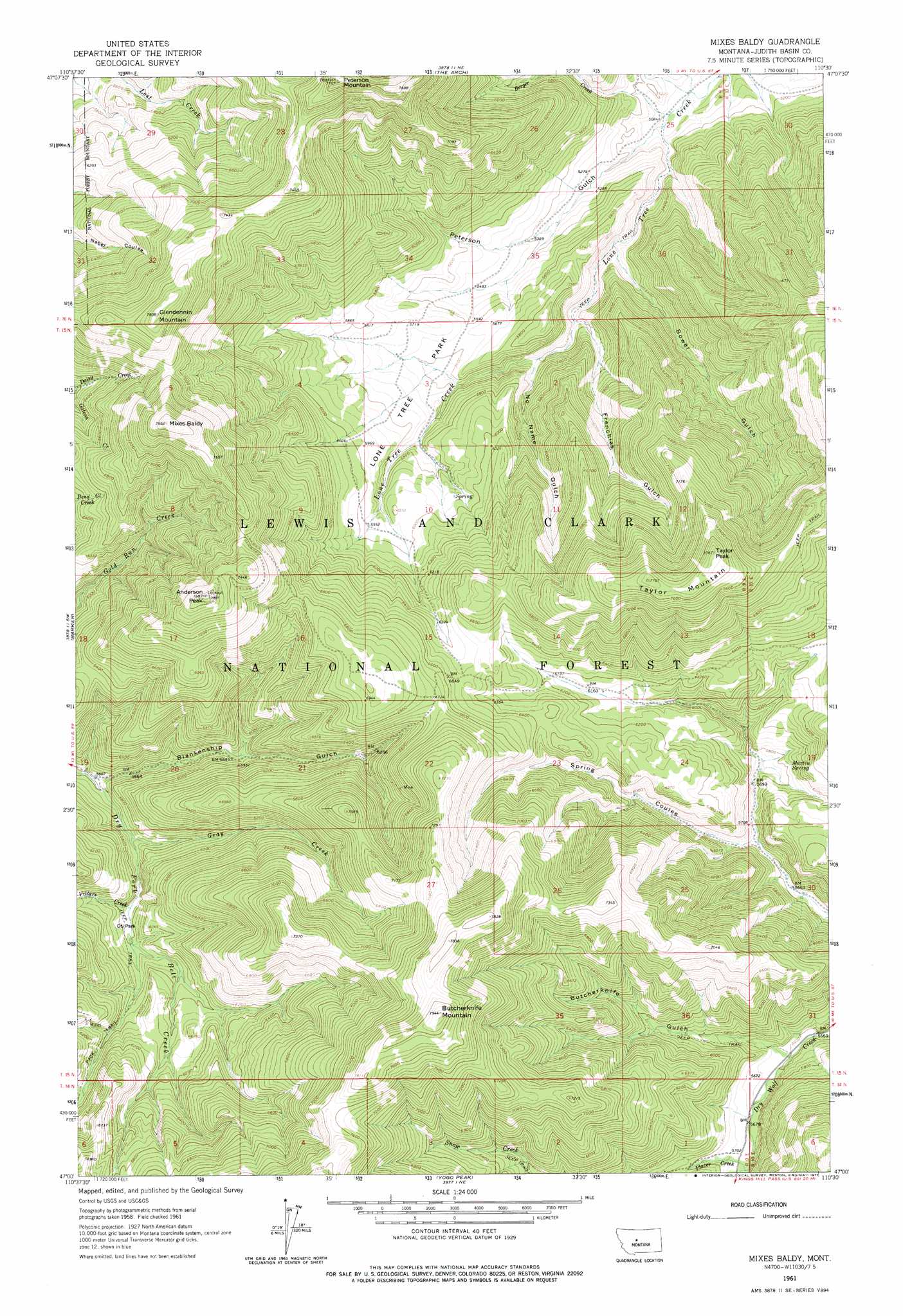
USGS Topo Quad 47110a5 - 1:24,000 scale
| Topo Map Name: | Mixes Baldy |
| USGS Topo Quad ID: | 47110a5 |
| Print Size: | ca. 21 1/4" wide x 27" high |
| Southeast Coordinates: | 47° N latitude / 110.5° W longitude |
| Map Center Coordinates: | 47.0625° N latitude / 110.5625° W longitude |
| U.S. State: | MT |
| Filename: | o47110a5.jpg |
| Download Map JPG Image: | Mixes Baldy topo map 1:24,000 scale |
| Map Type: | Topographic |
| Topo Series: | 7.5´ |
| Map Scale: | 1:24,000 |
| Source of Map Images: | United States Geological Survey (USGS) |
| Alternate Map Versions: |
Mixes Baldy MT 1961, updated 1964 Download PDF Buy paper map Mixes Baldy MT 1961, updated 1977 Download PDF Buy paper map Mixes Baldy MT 1995, updated 1997 Download PDF Buy paper map Mixes Baldy MT 2011 Download PDF Buy paper map Mixes Baldy MT 2014 Download PDF Buy paper map |
| FStopo: | US Forest Service topo Mixes Baldy is available: Download FStopo PDF Download FStopo TIF |
1:24,000 Topo Quads surrounding Mixes Baldy
Blythe |
Raynesford |
Byrne Creek |
Geyser |
Leiberg Coulee |
Monarch Ne |
Limestone Butte |
The Arch |
Wolf Butte Nw |
Merino |
Monarch |
Barker |
Mixes Baldy |
Wolf Butte |
Cayuse Basin |
Belt Park Butte |
Neihart |
Yogo Peak |
Band Box Mountain |
Woodhurst Mountain |
Moose Mountain |
Kings Hill |
Sand Point |
Ettien Spring |
Indian Hill |
> Back to 47110a1 at 1:100,000 scale
> Back to 47110a1 at 1:250,000 scale
> Back to U.S. Topo Maps home
Mixes Baldy topo map: Gazetteer
Mixes Baldy: Flats
Lone Tree Park elevation 1723m 5652′Oti Park elevation 1760m 5774′
Mixes Baldy: Mines
Harrison/Moulton Mine elevation 1904m 6246′Montgomery Mine elevation 1928m 6325′
Moulton Mine elevation 2011m 6597′
NE SE Section 31 Mine elevation 1903m 6243′
NE SW Section 22 Mine elevation 2016m 6614′
NW SW Section 22 Mine elevation 1913m 6276′
Tiger Mine elevation 2083m 6833′
Mixes Baldy: Post Offices
Geer Post Office (historical) elevation 1878m 6161′Niles Post Office (historical) elevation 1872m 6141′
Mixes Baldy: Springs
16N09E25AB__01 Spring elevation 1554m 5098′16N09E25CC__01 Spring elevation 1627m 5337′
Martin Spring elevation 1783m 5849′
Mixes Baldy: Streams
Berger Creek elevation 1543m 5062′Gray Creek elevation 1729m 5672′
Placer Creek elevation 1738m 5702′
Villars Creek elevation 1753m 5751′
Mixes Baldy: Summits
Anderson Peak elevation 2348m 7703′Butcherknife Mountain elevation 2417m 7929′
Clendenin Mountain elevation 2379m 7805′
Mixes Baldy elevation 2420m 7939′
Peterson Mountain elevation 2349m 7706′
Taylor Mountain elevation 2345m 7693′
Taylor Peak elevation 2374m 7788′
Mixes Baldy: Valleys
Blankenship Gulch elevation 1714m 5623′Bower Gulch elevation 1596m 5236′
Butcherknife Gulch elevation 1718m 5636′
Frenchies Gulch elevation 1661m 5449′
No Name Gulch elevation 1657m 5436′
Peterson Gulch elevation 1549m 5082′
Mixes Baldy: Wells
16N09E26D___01 Well elevation 1670m 5479′Mixes Baldy digital topo map on disk
Buy this Mixes Baldy topo map showing relief, roads, GPS coordinates and other geographical features, as a high-resolution digital map file on DVD: