Byrne Creek Topo Map Montana
To zoom in, hover over the map of Byrne Creek
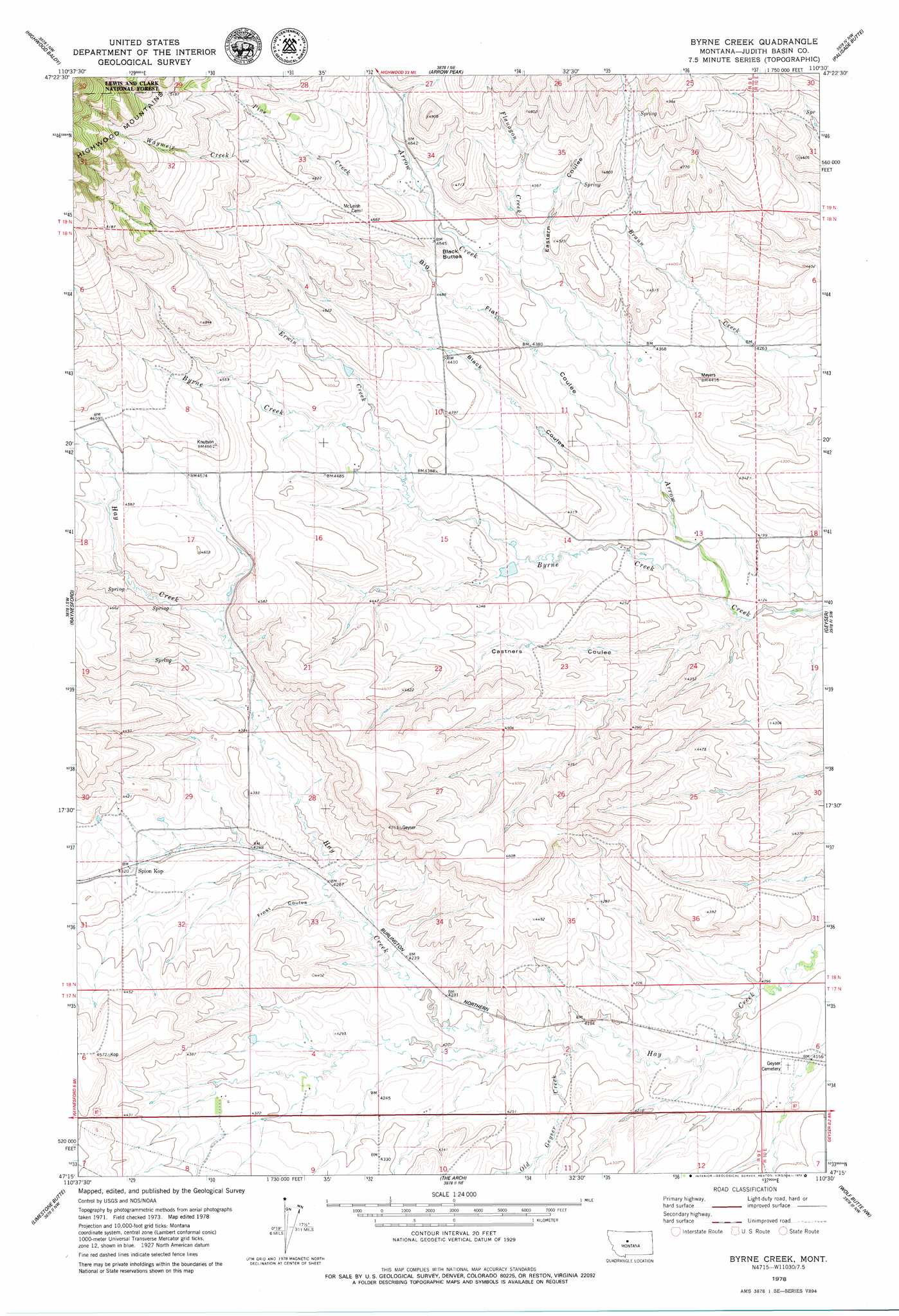
USGS Topo Quad 47110c5 - 1:24,000 scale
| Topo Map Name: | Byrne Creek |
| USGS Topo Quad ID: | 47110c5 |
| Print Size: | ca. 21 1/4" wide x 27" high |
| Southeast Coordinates: | 47.25° N latitude / 110.5° W longitude |
| Map Center Coordinates: | 47.3125° N latitude / 110.5625° W longitude |
| U.S. State: | MT |
| Filename: | o47110c5.jpg |
| Download Map JPG Image: | Byrne Creek topo map 1:24,000 scale |
| Map Type: | Topographic |
| Topo Series: | 7.5´ |
| Map Scale: | 1:24,000 |
| Source of Map Images: | United States Geological Survey (USGS) |
| Alternate Map Versions: |
Byrne Creek MT 1978, updated 1979 Download PDF Buy paper map Byrne Creek MT 1995, updated 1997 Download PDF Buy paper map Byrne Creek MT 2011 Download PDF Buy paper map Byrne Creek MT 2014 Download PDF Buy paper map |
| FStopo: | US Forest Service topo Byrne Creek is available: Download FStopo PDF Download FStopo TIF |
1:24,000 Topo Quads surrounding Byrne Creek
Highwood |
Big Sag |
Carter Mountain |
Lepleys Creek |
Geraldine |
Belt Ne |
Highwood Baldy |
Arrow Peak |
Palisade Butte |
Jiggs Flat |
Blythe |
Raynesford |
Byrne Creek |
Geyser |
Leiberg Coulee |
Monarch Ne |
Limestone Butte |
The Arch |
Wolf Butte Nw |
Merino |
Monarch |
Barker |
Mixes Baldy |
Wolf Butte |
Cayuse Basin |
> Back to 47110a1 at 1:100,000 scale
> Back to 47110a1 at 1:250,000 scale
> Back to U.S. Topo Maps home
Byrne Creek topo map: Gazetteer
Byrne Creek: Dams
Antares Dam elevation 1329m 4360′Mad Dam elevation 1377m 4517′
Byrne Creek: Populated Places
Spion Kop elevation 1318m 4324′Byrne Creek: Post Offices
Arrow Post Office (historical) elevation 1289m 4229′Spion Kop Post Office (historical) elevation 1318m 4324′
Byrne Creek: Springs
17N09E02AA__01 Spring elevation 1293m 4242′17N09E04CB__01 Spring elevation 1306m 4284′
17N09E04CD__01 Spring elevation 1304m 4278′
17N09E04DC__01 Spring elevation 1297m 4255′
17N09E04DC__02 Spring elevation 1297m 4255′
17N09E05AD__01 Spring elevation 1346m 4416′
17N09E05DB__01 Spring elevation 1330m 4363′
17N09E09BB__01 Spring elevation 1313m 4307′
18N09E09AB__01 Spring elevation 1367m 4484′
18N09E09AC__01 Spring elevation 1369m 4491′
18N09E12BB__01 Spring elevation 1318m 4324′
18N09E14AA__01 Spring elevation 1294m 4245′
18N09E16BA__01 Spring elevation 1372m 4501′
18N09E20BD__01 Spring elevation 1384m 4540′
18N09E23BC__01 Spring elevation 1320m 4330′
18N09E23CC__01 Spring elevation 1353m 4438′
18N09E27AB__01 Spring elevation 1420m 4658′
18N09E28AC__01 Spring elevation 1339m 4393′
18N10E06BB__01 Spring elevation 1341m 4399′
18N10E31CB__01 Spring elevation 1259m 4130′
19N09E35DB__01 Spring elevation 1419m 4655′
19N09E35DC__01 Spring elevation 1422m 4665′
19N09E36AA__01 Spring elevation 1433m 4701′
19N09E36BB__01 Spring elevation 1475m 4839′
19N09E36BD__01 Spring elevation 1478m 4849′
19N09E36CC__01 Spring elevation 1402m 4599′
19N10E31BA__01 Spring elevation 1396m 4580′
Byrne Creek: Streams
Byrne Creek elevation 1256m 4120′Erwin Creek elevation 1324m 4343′
Flanagan Creek elevation 1344m 4409′
Old Geyser Creek elevation 1273m 4176′
Pine Creek elevation 1381m 4530′
Waymeir Creek elevation 1434m 4704′
Byrne Creek: Summits
Black Buttes elevation 1380m 4527′Byrne Creek: Valleys
Black Coulee elevation 1273m 4176′Castners Coulee elevation 1255m 4117′
Eastern Coulee elevation 1318m 4324′
Flat Coulee elevation 1285m 4215′
Frost Coulee elevation 1293m 4242′
Byrne Creek: Wells
17N09E02A___01 Well elevation 1295m 4248′17N09E03AA__01 Well elevation 1297m 4255′
17N09E03AB__01 Well elevation 1296m 4251′
17N09E03CD__01 Well elevation 1289m 4229′
17N09E03CD__02 Well elevation 1289m 4229′
17N09E04AC__01 Well elevation 1306m 4284′
17N09E05DC__01 Well elevation 1321m 4333′
17N09E05DD__01 Well elevation 1314m 4311′
17N09E08AA__01 Well elevation 1321m 4333′
17N09E08AA__02 Well elevation 1321m 4333′
17N09E08AACA01 Well elevation 1319m 4327′
17N09E08ABDA01 Well elevation 1321m 4333′
17N09E10B___01 Well elevation 1311m 4301′
17N10E06CC__01 Well elevation 1270m 4166′
18N09E02C___01 Well elevation 1341m 4399′
18N09E08CD__01 Well elevation 1393m 4570′
18N09E09CD__01 Well elevation 1365m 4478′
18N09E12CC__01 Well elevation 1300m 4265′
18N09E13BB__01 Well elevation 1297m 4255′
18N09E14B___01 Well elevation 1325m 4347′
18N09E14DA__01 Well elevation 1281m 4202′
18N09E16BA__02 Well elevation 1372m 4501′
18N09E17ADBC01 Well elevation 1385m 4543′
18N09E17BB__01 Well elevation 1394m 4573′
18N09E20C___01 Well elevation 1376m 4514′
18N09E20DD__01 Well elevation 1346m 4416′
18N09E30DA__01 Well elevation 1344m 4409′
18N09E31AA__01 Well elevation 1319m 4327′
18N09E32ACAB01 Well elevation 1322m 4337′
18N09E35A___01 Well elevation 1322m 4337′
Byrne Creek digital topo map on disk
Buy this Byrne Creek topo map showing relief, roads, GPS coordinates and other geographical features, as a high-resolution digital map file on DVD: