Raynesford Topo Map Montana
To zoom in, hover over the map of Raynesford
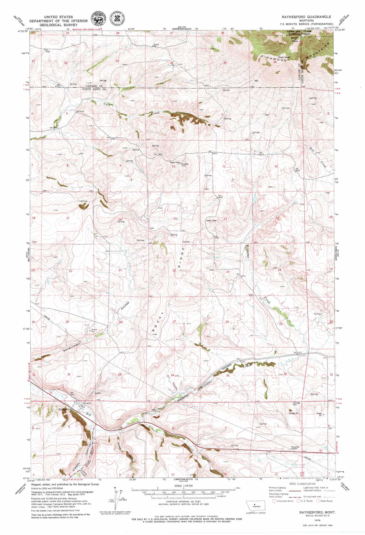
USGS Topo Quad 47110c6 - 1:24,000 scale
| Topo Map Name: | Raynesford |
| USGS Topo Quad ID: | 47110c6 |
| Print Size: | ca. 21 1/4" wide x 27" high |
| Southeast Coordinates: | 47.25° N latitude / 110.625° W longitude |
| Map Center Coordinates: | 47.3125° N latitude / 110.6875° W longitude |
| U.S. State: | MT |
| Filename: | o47110c6.jpg |
| Download Map JPG Image: | Raynesford topo map 1:24,000 scale |
| Map Type: | Topographic |
| Topo Series: | 7.5´ |
| Map Scale: | 1:24,000 |
| Source of Map Images: | United States Geological Survey (USGS) |
| Alternate Map Versions: |
Raynesford MT 1995, updated 1997 Download PDF Buy paper map Raynesford MT 2011 Download PDF Buy paper map Raynesford MT 2014 Download PDF Buy paper map |
| FStopo: | US Forest Service topo Raynesford is available: Download FStopo PDF Download FStopo TIF |
1:24,000 Topo Quads surrounding Raynesford
Waltham |
Highwood |
Big Sag |
Carter Mountain |
Lepleys Creek |
Belt |
Belt Ne |
Highwood Baldy |
Arrow Peak |
Palisade Butte |
Armington |
Blythe |
Raynesford |
Byrne Creek |
Geyser |
Riceville |
Monarch Ne |
Limestone Butte |
The Arch |
Wolf Butte Nw |
Thunder Mountain |
Monarch |
Barker |
Mixes Baldy |
Wolf Butte |
> Back to 47110a1 at 1:100,000 scale
> Back to 47110a1 at 1:250,000 scale
> Back to U.S. Topo Maps home
Raynesford topo map: Gazetteer
Raynesford: Populated Places
Mann (historical) elevation 1233m 4045′Raynesford elevation 1232m 4041′
Raynesford: Post Offices
Mann Post Office elevation 1233m 4045′Otter Post Office (historical) elevation 1233m 4045′
Raynesford Post Office elevation 1232m 4041′
Raynesford: Ridges
Rocky Ridge elevation 1433m 4701′Raynesford: Streams
Little Otter Creek elevation 1233m 4045′Williams Creek elevation 1246m 4087′
Raynesford: Summits
South Peak elevation 2157m 7076′Raynesford: Valleys
Cache Coulee elevation 1255m 4117′Dry Coulee elevation 1269m 4163′
Kibbey Canyon elevation 1233m 4045′
Ridley Coulee elevation 1242m 4074′
Raynesford: Wells
17N08E03A___01 Well elevation 1337m 4386′18N08E10C___01 Well elevation 1481m 4858′
18N08E12BBCC01 Well elevation 1466m 4809′
18N08E13A___01 Well elevation 1425m 4675′
18N08E20____01 Well elevation 1356m 4448′
18N08E24A___01 Well elevation 1419m 4655′
18N08E28____01 Well elevation 1286m 4219′
18N08E29____01 Well elevation 1287m 4222′
Raynesford digital topo map on disk
Buy this Raynesford topo map showing relief, roads, GPS coordinates and other geographical features, as a high-resolution digital map file on DVD: