Carter Mountain Topo Map Montana
To zoom in, hover over the map of Carter Mountain
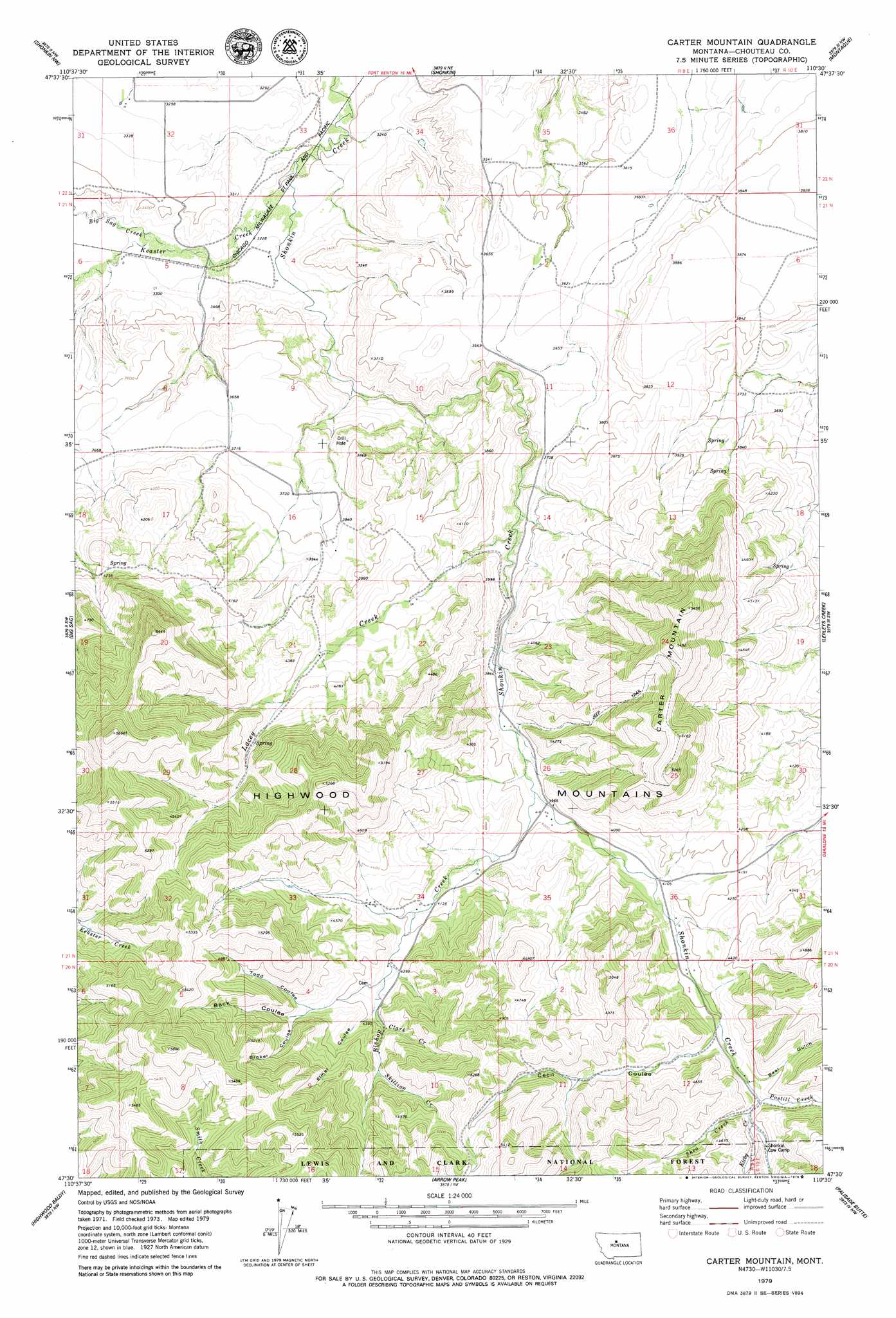
USGS Topo Quad 47110e5 - 1:24,000 scale
| Topo Map Name: | Carter Mountain |
| USGS Topo Quad ID: | 47110e5 |
| Print Size: | ca. 21 1/4" wide x 27" high |
| Southeast Coordinates: | 47.5° N latitude / 110.5° W longitude |
| Map Center Coordinates: | 47.5625° N latitude / 110.5625° W longitude |
| U.S. State: | MT |
| Filename: | o47110e5.jpg |
| Download Map JPG Image: | Carter Mountain topo map 1:24,000 scale |
| Map Type: | Topographic |
| Topo Series: | 7.5´ |
| Map Scale: | 1:24,000 |
| Source of Map Images: | United States Geological Survey (USGS) |
| Alternate Map Versions: |
Carter Mountain MT 1995, updated 1997 Download PDF Buy paper map Carter Mountain MT 2011 Download PDF Buy paper map Carter Mountain MT 2014 Download PDF Buy paper map |
| FStopo: | US Forest Service topo Carter Mountain is available: Download FStopo PDF Download FStopo TIF |
1:24,000 Topo Quads surrounding Carter Mountain
Tunis |
Fort Benton |
O'Hanlon Coulee |
Rocky Lake |
Stranahan Se |
Rice Reservoir |
Shonkin Nw |
Shonkin |
Montague |
Geraldine Ne |
Highwood |
Big Sag |
Carter Mountain |
Lepleys Creek |
Geraldine |
Belt Ne |
Highwood Baldy |
Arrow Peak |
Palisade Butte |
Jiggs Flat |
Blythe |
Raynesford |
Byrne Creek |
Geyser |
Leiberg Coulee |
> Back to 47110e1 at 1:100,000 scale
> Back to 47110a1 at 1:250,000 scale
> Back to U.S. Topo Maps home
Carter Mountain topo map: Gazetteer
Carter Mountain: Bridges
Shonkin Creek Bridge elevation 1415m 4642′Carter Mountain: Streams
Big Sag Creek elevation 992m 3254′Bishop Creek elevation 1202m 3943′
Clark Creek elevation 1340m 4396′
Kirby Creek elevation 1322m 4337′
Lacey Creek elevation 1118m 3667′
Postill Creek elevation 1315m 4314′
Shea Creek elevation 1317m 4320′
Skillion Creek elevation 1371m 4498′
Carter Mountain: Summits
Carter Mountain elevation 1671m 5482′Carter Mountain: Valleys
Back Coulee elevation 1373m 4504′Bear Gulch elevation 1321m 4333′
Broker Coulee elevation 1377m 4517′
Cecil Coulee elevation 1295m 4248′
Elmer Coulee elevation 1317m 4320′
Todd Coulee elevation 1363m 4471′
Carter Mountain digital topo map on disk
Buy this Carter Mountain topo map showing relief, roads, GPS coordinates and other geographical features, as a high-resolution digital map file on DVD: