Montague Topo Map Montana
To zoom in, hover over the map of Montague
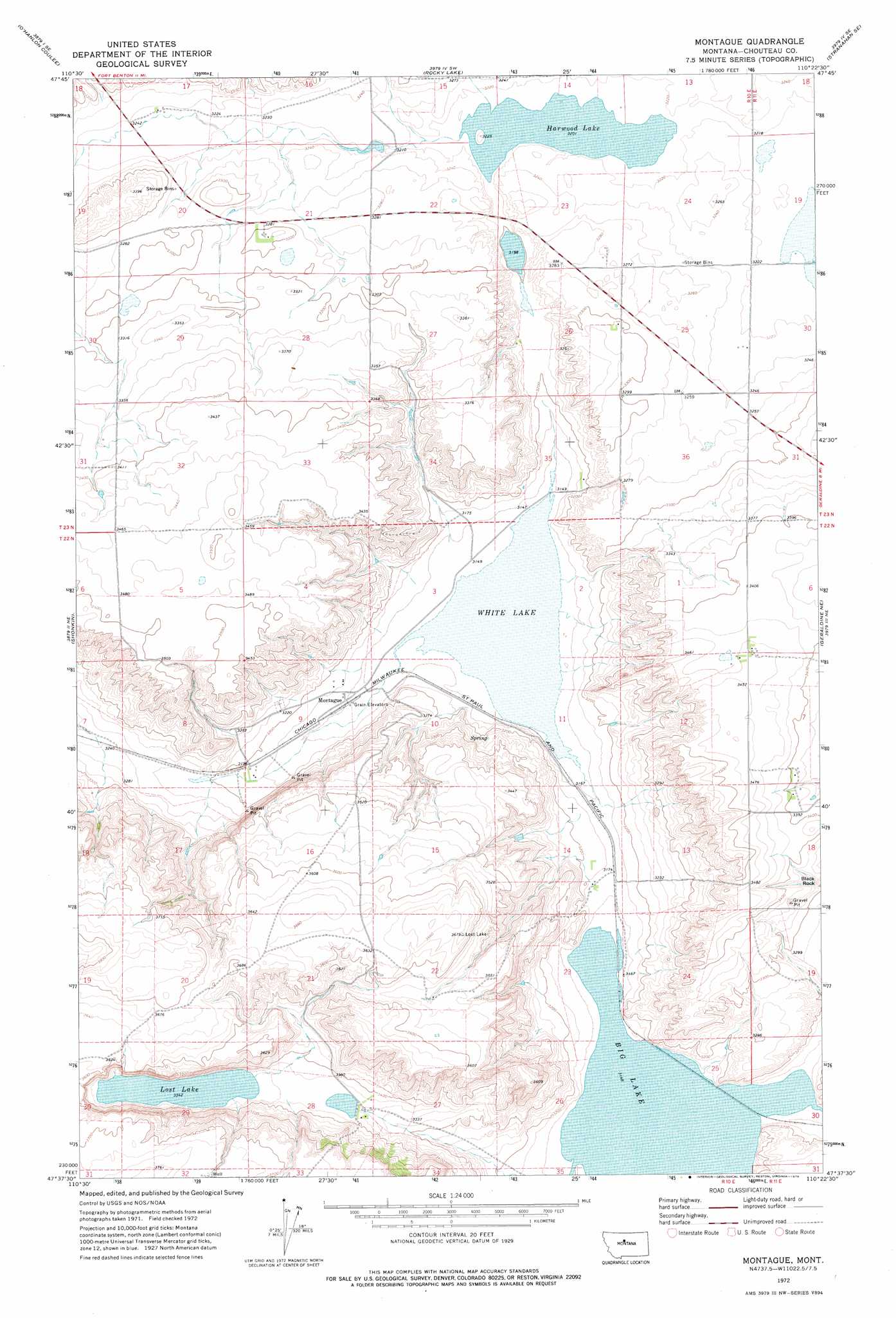
USGS Topo Quad 47110f4 - 1:24,000 scale
| Topo Map Name: | Montague |
| USGS Topo Quad ID: | 47110f4 |
| Print Size: | ca. 21 1/4" wide x 27" high |
| Southeast Coordinates: | 47.625° N latitude / 110.375° W longitude |
| Map Center Coordinates: | 47.6875° N latitude / 110.4375° W longitude |
| U.S. State: | MT |
| Filename: | o47110f4.jpg |
| Download Map JPG Image: | Montague topo map 1:24,000 scale |
| Map Type: | Topographic |
| Topo Series: | 7.5´ |
| Map Scale: | 1:24,000 |
| Source of Map Images: | United States Geological Survey (USGS) |
| Alternate Map Versions: |
Montague MT 1972, updated 1976 Download PDF Buy paper map Montague MT 2011 Download PDF Buy paper map Montague MT 2014 Download PDF Buy paper map |
1:24,000 Topo Quads surrounding Montague
Fort Benton Nw |
Loma West |
Loma East |
Stranahan |
Big Bend School |
Fort Benton |
O'Hanlon Coulee |
Rocky Lake |
Stranahan Se |
Eagle Buttes Sw |
Shonkin Nw |
Shonkin |
Montague |
Geraldine Ne |
Dammel Reservoir |
Big Sag |
Carter Mountain |
Lepleys Creek |
Geraldine |
Square Butte |
Highwood Baldy |
Arrow Peak |
Palisade Butte |
Jiggs Flat |
Pownal |
> Back to 47110e1 at 1:100,000 scale
> Back to 47110a1 at 1:250,000 scale
> Back to U.S. Topo Maps home
Montague topo map: Gazetteer
Montague: Dams
Kheta Dam elevation 1026m 3366′Montague: Lakes
Big Lake elevation 960m 3149′Harwood Lake elevation 977m 3205′
Lost Lake elevation 1019m 3343′
White Lake elevation 960m 3149′
Montague: Pillars
Black Rock elevation 1018m 3339′Montague: Populated Places
Montague elevation 962m 3156′Montague: Post Offices
Davidson Post Office (historical) elevation 1001m 3284′Lostlake Post Office (historical) elevation 1027m 3369′
Montague Post Office (historical) elevation 963m 3159′
Montague: Streams
Lepleys Creek elevation 961m 3152′Montague: Valleys
Telephone Coulee elevation 977m 3205′Windy Coulee elevation 976m 3202′
Montague digital topo map on disk
Buy this Montague topo map showing relief, roads, GPS coordinates and other geographical features, as a high-resolution digital map file on DVD: