Morony Dam Topo Map Montana
To zoom in, hover over the map of Morony Dam
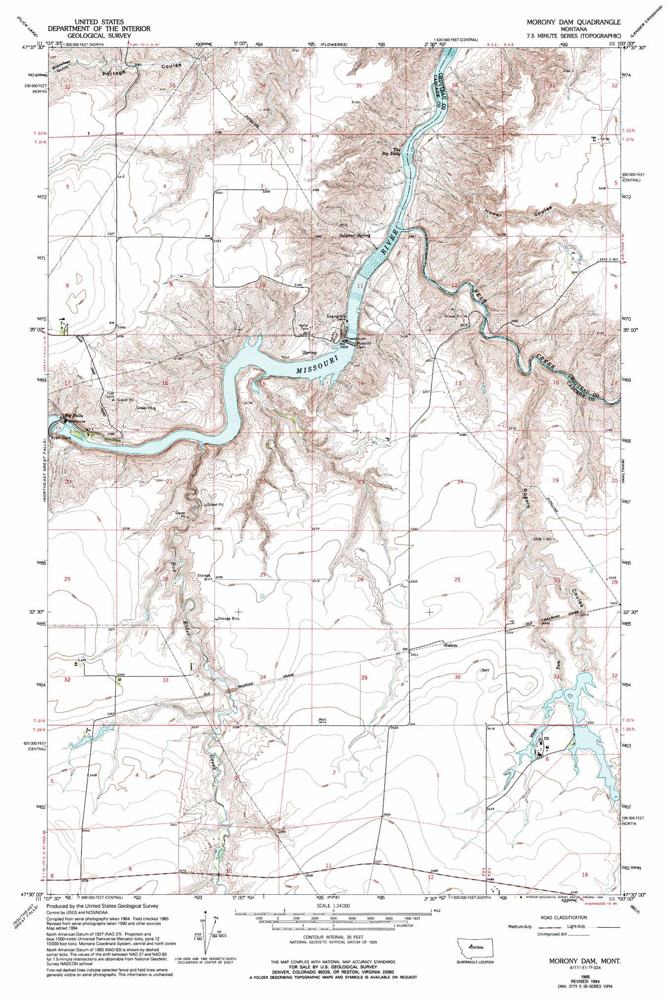
USGS Topo Quad 47111e1 - 1:24,000 scale
| Topo Map Name: | Morony Dam |
| USGS Topo Quad ID: | 47111e1 |
| Print Size: | ca. 21 1/4" wide x 27" high |
| Southeast Coordinates: | 47.5° N latitude / 111° W longitude |
| Map Center Coordinates: | 47.5625° N latitude / 111.0625° W longitude |
| U.S. State: | MT |
| Filename: | o47111e1.jpg |
| Download Map JPG Image: | Morony Dam topo map 1:24,000 scale |
| Map Type: | Topographic |
| Topo Series: | 7.5´ |
| Map Scale: | 1:24,000 |
| Source of Map Images: | United States Geological Survey (USGS) |
| Alternate Map Versions: |
Morony Dam MT 1965, updated 1968 Download PDF Buy paper map Morony Dam MT 1965, updated 1994 Download PDF Buy paper map Morony Dam MT 2011 Download PDF Buy paper map Morony Dam MT 2014 Download PDF Buy paper map |
1:24,000 Topo Quads surrounding Morony Dam
Sheep Coulee Springs |
Antelope Flat |
Antelope Lake |
Carter |
Tunis |
Benton Lake East |
Flick Lake |
Floweree |
Lander Crossing |
Rice Reservoir |
Northwest Great Falls |
Northeast Great Falls |
Morony Dam |
Waltham |
Highwood |
Southwest Great Falls |
Southeast Great Falls |
Fife |
Belt |
Belt Ne |
Eden |
Stockett |
Mahoney Hill |
Armington |
Blythe |
> Back to 47111e1 at 1:100,000 scale
> Back to 47110a1 at 1:250,000 scale
> Back to U.S. Topo Maps home
Morony Dam topo map: Gazetteer
Morony Dam: Bridges
Salem Road Bridge elevation 861m 2824′Morony Dam: Dams
Morony Dam elevation 868m 2847′O'Day Number 1 Dam elevation 1035m 3395′
O'Day Number 2 Dam elevation 1005m 3297′
Prairie Nest Ranch 1 Dam elevation 1020m 3346′
Prairie Nest Ranch 2 Dam elevation 1025m 3362′
Prairie Nest Ranch 3 Dam elevation 1033m 3389′
Prairie Nest Ranch 4 Dam elevation 1025m 3362′
Ryan Dam elevation 924m 3031′
Morony Dam: Falls
Big Falls elevation 918m 3011′Morony Dam: Populated Places
Salem elevation 1024m 3359′Morony Dam: Post Offices
Salem Post Office (historical) elevation 1024m 3359′Morony Dam: Rapids
The Big Eddy elevation 846m 2775′Morony Dam: Reservoirs
Morony Reservoir elevation 868m 2847′Morony Dam: Springs
Sulphur Spring elevation 878m 2880′Morony Dam: Streams
Belt Creek elevation 851m 2791′Box Elder Creek elevation 887m 2910′
Morony Dam: Valleys
Blackfeet Gulch elevation 946m 3103′Hower Coulee elevation 847m 2778′
Rogers Coulee elevation 876m 2874′
West Fork Rogers Coulee elevation 972m 3188′
Morony Dam: Wells
20N05E10BADC01 Well elevation 1019m 3343′Morony Dam digital topo map on disk
Buy this Morony Dam topo map showing relief, roads, GPS coordinates and other geographical features, as a high-resolution digital map file on DVD: