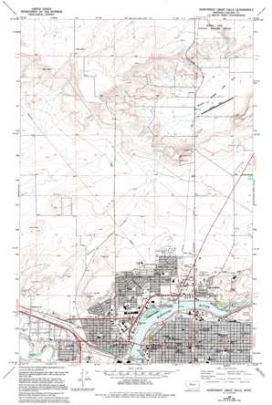
Northwest Great Falls Topo Map Montana
To zoom in, hover over the map of Northwest Great Falls
USGS Topo Quad 47111e3 - 1:24,000 scale
| Topo Map Name: | Northwest Great Falls |
| USGS Topo Quad ID: | 47111e3 |
| Print Size: | ca. 21 1/4" wide x 27" high |
| Southeast Coordinates: | 47.5° N latitude / 111.25° W longitude |
| Map Center Coordinates: | 47.5625° N latitude / 111.3125° W longitude |
| U.S. State: | MT |
| Filename: | o47111e3.jpg |
| Download Map JPG Image: | Northwest Great Falls topo map 1:24,000 scale |
| Map Type: | Topographic |
| Topo Series: | 7.5´ |
| Map Scale: | 1:24,000 |
| Source of Map Images: | United States Geological Survey (USGS) |
| Alternate Map Versions: |
Northwest Great Falls MT 1965, updated 1968 Download PDF Buy paper map Northwest Great Falls MT 1965, updated 1977 Download PDF Buy paper map Northwest Great Falls MT 1965, updated 1994 Download PDF Buy paper map Northwest Great Falls MT 2011 Download PDF Buy paper map Northwest Great Falls MT 2014 Download PDF Buy paper map |
1:24,000 Topo Quads surrounding Northwest Great Falls
> Back to 47111e1 at 1:100,000 scale
> Back to 47110a1 at 1:250,000 scale
> Back to U.S. Topo Maps home
Northwest Great Falls topo map: Gazetteer
Northwest Great Falls: Airports
Horner Field elevation 1047m 3435′Northwest Great Falls: Bridges
Chicago Milwaukee Saint Paul and Pacific Railroad Bridge elevation 1038m 3405′Fifteenth Street Bridge elevation 1010m 3313′
First Avenue North Bridge elevation 1010m 3313′
Missouri River Bridge elevation 1010m 3313′
Northwest Great Falls: Crossings
Interchange 280 elevation 1013m 3323′Northwest Great Falls: Dams
Black Eagle Dam elevation 1007m 3303′Northwest Great Falls: Falls
Black Eagle Falls elevation 1001m 3284′Northwest Great Falls: Islands
Sacajawea Island elevation 1010m 3313′Northwest Great Falls: Parks
Black Eagle Falls Historical Marker elevation 1034m 3392′Bloomingdale Park elevation 1019m 3343′
Cambridge Court Park elevation 1025m 3362′
Gallatin Park elevation 1032m 3385′
Gibson Park elevation 1013m 3323′
Girl Scout Park elevation 1013m 3323′
Horizon Park elevation 1054m 3458′
Kid Russell and Monte Statue elevation 1014m 3326′
Kiwanis Park elevation 1040m 3412′
Kranz Park elevation 1031m 3382′
Madison Park elevation 1031m 3382′
Memorial Park elevation 1038m 3405′
Morony Park elevation 1026m 3366′
Paris Gibson Square elevation 1030m 3379′
Rhodes Park elevation 1015m 3330′
Riverside Park elevation 1013m 3323′
Riverview Park elevation 1026m 3366′
Rolling Thunder Sculpture elevation 1013m 3323′
Skyline Park elevation 1074m 3523′
Sunset Park elevation 1013m 3323′
Valley View Park elevation 1024m 3359′
Veterans Memorial Park elevation 1045m 3428′
West Bank Park elevation 1015m 3330′
West Bank Park elevation 1012m 3320′
West Side Kiwanis Park elevation 1017m 3336′
Westside Viaduct Park elevation 1015m 3330′
Whittier Park elevation 1013m 3323′
Northwest Great Falls: Populated Places
Black Eagle elevation 1030m 3379′Boston Heights (historical) elevation 1062m 3484′
Countryside Village elevation 1072m 3517′
Emerson Junction elevation 1024m 3359′
Garrett Mobile Home Park elevation 1013m 3323′
Great Falls elevation 1015m 3330′
Johnstown (historical) elevation 1013m 3323′
Little Chicago (historical) elevation 1044m 3425′
North Great Falls (historical) elevation 1077m 3533′
Smelter Hill elevation 1038m 3405′
Watson (historical) elevation 1072m 3517′
Northwest Great Falls: Post Offices
Black Eagle Post Office (historical) elevation 1030m 3379′Great Falls Post Office elevation 1014m 3326′
Johnstown Post Office (historical) elevation 1013m 3323′
North Great Falls Post Office (historical) elevation 1077m 3533′
Northwest Great Falls: Summits
Hill Fifty-seven elevation 1093m 3585′Indian Butte elevation 1088m 3569′
Smelter Hill elevation 1039m 3408′
Northwest Great Falls: Valleys
Watson Coulee elevation 1020m 3346′Northwest Great Falls: Wells
20N03E02BADD01 Well elevation 1019m 3343′20N03E04CDAC01 Well elevation 1012m 3320′
20N03E05A___01 Well elevation 1018m 3339′
20N03E09B___01 Well elevation 1014m 3326′
20N03E12AACC01 Well elevation 1022m 3353′
20N04E07BDAC01 Well elevation 1037m 3402′
20N04E07BDCD01 Well elevation 1033m 3389′
21N03E03DDAC01 Well elevation 1155m 3789′
21N03E12DADA01 Well elevation 1052m 3451′
21N03E14AABA01 Well elevation 1130m 3707′
21N03E14AABC01 Well elevation 1129m 3704′
21N04E05CBAB01 Well elevation 1044m 3425′
21N04E32CABA01 Well elevation 1036m 3398′
21N04E32CABA02 Well elevation 1034m 3392′
21N04E33CDDA01 Well elevation 1039m 3408′
Northwest Great Falls digital topo map on disk
Buy this Northwest Great Falls topo map showing relief, roads, GPS coordinates and other geographical features, as a high-resolution digital map file on DVD:


