Fort Shaw Topo Map Montana
To zoom in, hover over the map of Fort Shaw
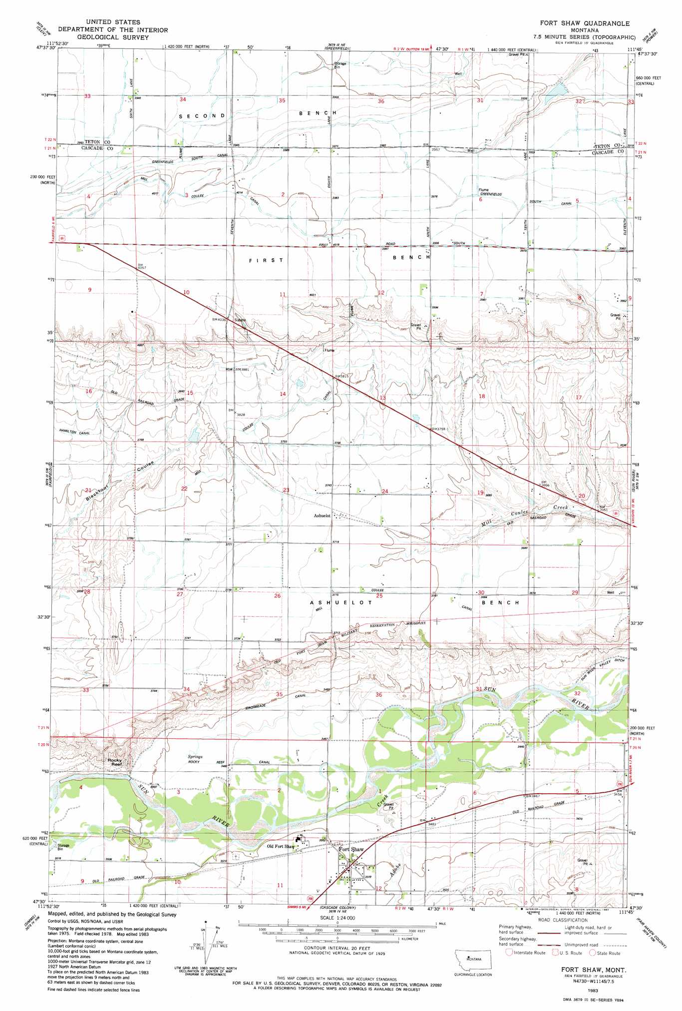
USGS Topo Quad 47111e7 - 1:24,000 scale
| Topo Map Name: | Fort Shaw |
| USGS Topo Quad ID: | 47111e7 |
| Print Size: | ca. 21 1/4" wide x 27" high |
| Southeast Coordinates: | 47.5° N latitude / 111.75° W longitude |
| Map Center Coordinates: | 47.5625° N latitude / 111.8125° W longitude |
| U.S. State: | MT |
| Filename: | o47111e7.jpg |
| Download Map JPG Image: | Fort Shaw topo map 1:24,000 scale |
| Map Type: | Topographic |
| Topo Series: | 7.5´ |
| Map Scale: | 1:24,000 |
| Source of Map Images: | United States Geological Survey (USGS) |
| Alternate Map Versions: |
Fort Shaw MT 1983, updated 1983 Download PDF Buy paper map Fort Shaw MT 2011 Download PDF Buy paper map Fort Shaw MT 2014 Download PDF Buy paper map |
1:24,000 Topo Quads surrounding Fort Shaw
Choteau Se |
T L Gap |
Collins Se |
Dutton |
Dutton Se |
Freezeout Lake |
Cleiv |
Greenfield |
Power |
Vaughn Ne |
Lowry |
Fairfield |
Fort Shaw |
Sun River |
Vaughn |
Bowmans Corners Ne |
Simms |
Cascade Colony |
Fair Haven Colony |
Ulm |
Henry Creek |
Telegraph Mountain |
Mount Cecelia |
Cascade |
Nelson Island |
> Back to 47111e1 at 1:100,000 scale
> Back to 47110a1 at 1:250,000 scale
> Back to U.S. Topo Maps home
Fort Shaw topo map: Gazetteer
Fort Shaw: Benches
Ashuelot Bench elevation 1139m 3736′First Bench elevation 1217m 3992′
Fort Shaw: Canals
Birchmeade Canal elevation 1066m 3497′Canal K elevation 1055m 3461′
Greenfield South Canal elevation 1208m 3963′
GS 51 Ditch elevation 1198m 3930′
Mill Coulee Canal elevation 1162m 3812′
Rocky Reef Canal elevation 1061m 3480′
Fort Shaw: Cliffs
Rocky Reef elevation 1102m 3615′Fort Shaw: Dams
Moving' Along Dam elevation 1179m 3868′Fort Shaw: Parks
Fort Shaw Historical Marker elevation 1072m 3517′Fort Shaw: Populated Places
Ashuelot elevation 1135m 3723′Fort Shaw elevation 1068m 3503′
Fort Shaw: Post Offices
Fort Shaw Post Office elevation 1068m 3503′Fort Shaw: Wells
21N01W06DCC_01 Well elevation 1215m 3986′21N01W30C___01 Well elevation 1125m 3690′
21N01W30CBA_01 Well elevation 1127m 3697′
21N01W30D___01 Well elevation 1123m 3684′
21N01W31A___01 Well elevation 1068m 3503′
Fort Shaw digital topo map on disk
Buy this Fort Shaw topo map showing relief, roads, GPS coordinates and other geographical features, as a high-resolution digital map file on DVD: