Blowout Mountain Topo Map Montana
To zoom in, hover over the map of Blowout Mountain
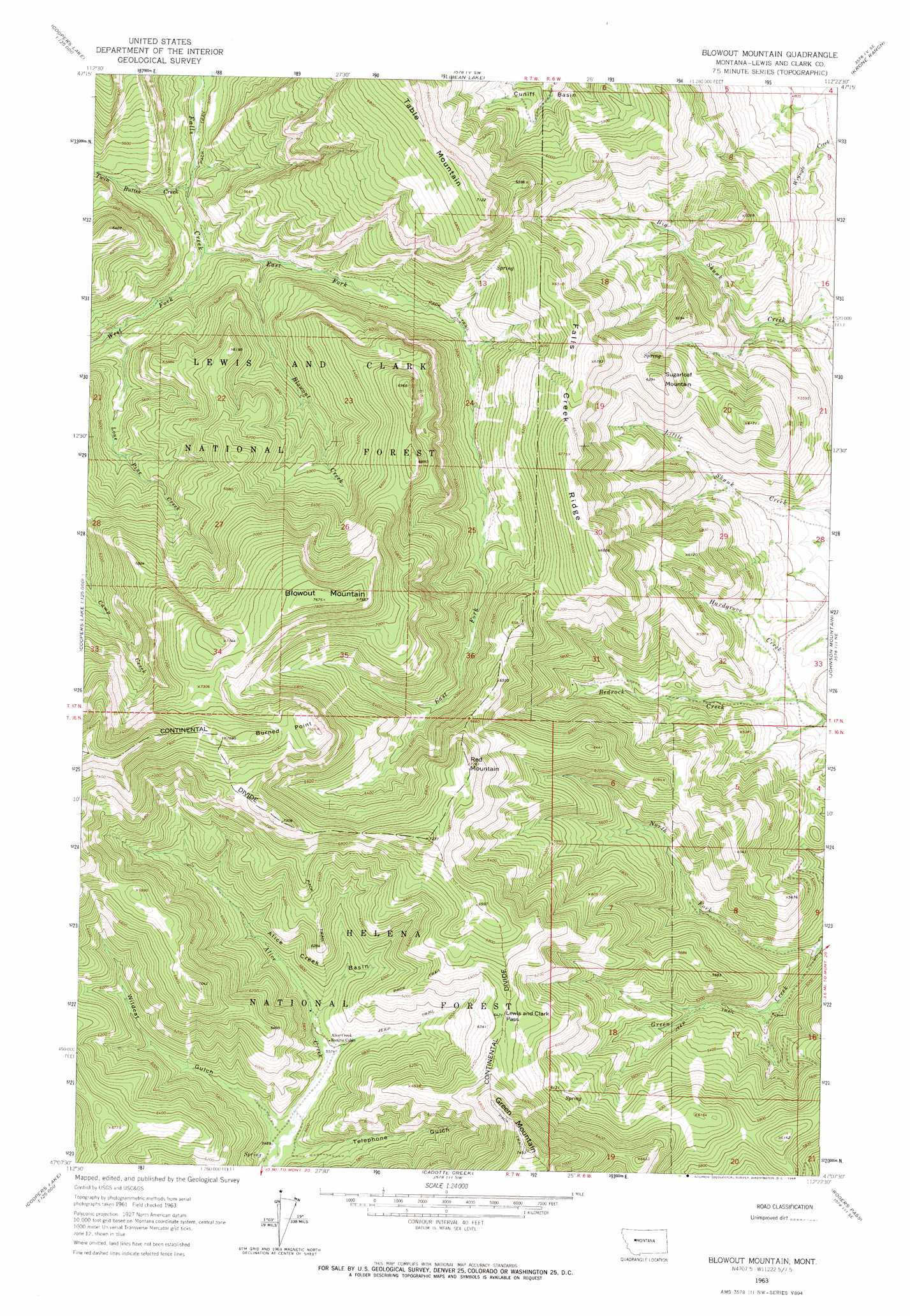
USGS Topo Quad 47112b4 - 1:24,000 scale
| Topo Map Name: | Blowout Mountain |
| USGS Topo Quad ID: | 47112b4 |
| Print Size: | ca. 21 1/4" wide x 27" high |
| Southeast Coordinates: | 47.125° N latitude / 112.375° W longitude |
| Map Center Coordinates: | 47.1875° N latitude / 112.4375° W longitude |
| U.S. State: | MT |
| Filename: | o47112b4.jpg |
| Download Map JPG Image: | Blowout Mountain topo map 1:24,000 scale |
| Map Type: | Topographic |
| Topo Series: | 7.5´ |
| Map Scale: | 1:24,000 |
| Source of Map Images: | United States Geological Survey (USGS) |
| Alternate Map Versions: |
Blowout Mountain MT 1963, updated 1964 Download PDF Buy paper map Blowout Mountain MT 1995, updated 1997 Download PDF Buy paper map Blowout Mountain MT 2011 Download PDF Buy paper map Blowout Mountain MT 2014 Download PDF Buy paper map |
| FStopo: | US Forest Service topo Blowout Mountain is available: Download FStopo PDF Download FStopo TIF |
1:24,000 Topo Quads surrounding Blowout Mountain
Double Falls |
Nilan Reservoir |
Augusta |
Gouchnour Ranch |
Bowmans Corners Nw |
Jakie Creek |
Steamboat Mountain |
Bean Lake |
Krone Ranch |
Bowmans Corners |
Heart Lake |
Caribou Peak |
Blowout Mountain |
Johnson Mountain |
Comb Rock |
Stonewall Mountain |
Silver King Mountain |
Cadotte Creek |
Rogers Pass |
Roberts Mountain |
Lincoln |
Swede Gulch |
Stemple Pass |
Wilborn |
Mitchell Mountain |
> Back to 47112a1 at 1:100,000 scale
> Back to 47112a1 at 1:250,000 scale
> Back to U.S. Topo Maps home
Blowout Mountain topo map: Gazetteer
Blowout Mountain: Basins
Alice Creek Basin elevation 1748m 5734′Blowout Mountain: Capes
Burned Point elevation 2312m 7585′Blowout Mountain: Gaps
Lewis and Clark Pass elevation 1958m 6423′Blowout Mountain: Ridges
Falls Creek Ridge elevation 2059m 6755′Blowout Mountain: Streams
Blowout Creek elevation 1568m 5144′East Fork Falls Creek elevation 1541m 5055′
Lone Pine Creek elevation 1575m 5167′
North Fork Green Creek elevation 1463m 4799′
Twin Buttes Creek elevation 1524m 5000′
West Fork Falls Creek elevation 1541m 5055′
Blowout Mountain: Summits
Blowout Mountain elevation 2334m 7657′Green Mountain elevation 2269m 7444′
Red Mountain elevation 2211m 7253′
Sugarloaf Mountain elevation 1915m 6282′
Blowout Mountain: Valleys
Telephone Gulch elevation 1680m 5511′Wildcat Gulch elevation 1676m 5498′
Blowout Mountain digital topo map on disk
Buy this Blowout Mountain topo map showing relief, roads, GPS coordinates and other geographical features, as a high-resolution digital map file on DVD: