Bowmans Corners Nw Topo Map Montana
To zoom in, hover over the map of Bowmans Corners Nw
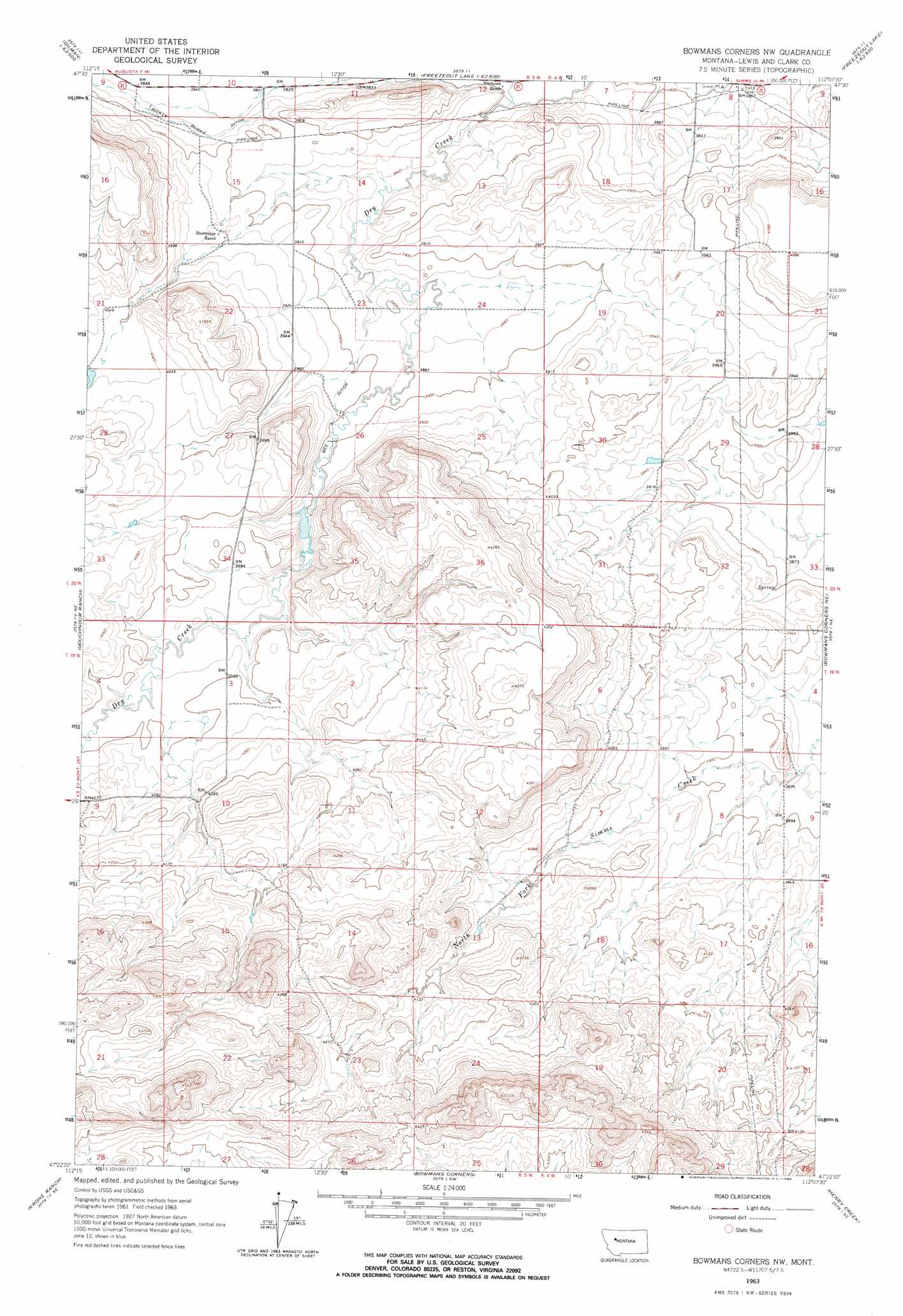
USGS Topo Quad 47112d2 - 1:24,000 scale
| Topo Map Name: | Bowmans Corners Nw |
| USGS Topo Quad ID: | 47112d2 |
| Print Size: | ca. 21 1/4" wide x 27" high |
| Southeast Coordinates: | 47.375° N latitude / 112.125° W longitude |
| Map Center Coordinates: | 47.4375° N latitude / 112.1875° W longitude |
| U.S. State: | MT |
| Filename: | o47112d2.jpg |
| Download Map JPG Image: | Bowmans Corners Nw topo map 1:24,000 scale |
| Map Type: | Topographic |
| Topo Series: | 7.5´ |
| Map Scale: | 1:24,000 |
| Source of Map Images: | United States Geological Survey (USGS) |
| Alternate Map Versions: |
Bowmans Corners NW MT 1963, updated 1964 Download PDF Buy paper map Bowmans Corners NW MT 2011 Download PDF Buy paper map Bowmans Corners NW MT 2014 Download PDF Buy paper map |
1:24,000 Topo Quads surrounding Bowmans Corners Nw
Pishkun Reservoir |
Nunemaker Hill |
Sevenmile Hill |
Freezeout Lake |
Cleiv |
Split Rock Junction |
Gilman |
Golden Ridge |
Lowry |
Fairfield |
Augusta |
Gouchnour Ranch |
Bowmans Corners Nw |
Bowmans Corners Ne |
Simms |
Bean Lake |
Krone Ranch |
Bowmans Corners |
Henry Creek |
Telegraph Mountain |
Blowout Mountain |
Johnson Mountain |
Comb Rock |
Coburn Mountain |
Mid Canon |
> Back to 47112a1 at 1:100,000 scale
> Back to 47112a1 at 1:250,000 scale
> Back to U.S. Topo Maps home
Bowmans Corners Nw topo map: Gazetteer
Bowmans Corners Nw: Canals
Bee Ditch elevation 1191m 3907′Bickle Burke Ditch elevation 1177m 3861′
Bowmans Corners Nw: Dams
Krezelok Dam elevation 1192m 3910′Bowmans Corners Nw: Reservoirs
Dry Creek-Krezelok Reservoir elevation 1192m 3910′Bowmans Corners Nw: Wells
20N05W09D___01 Well elevation 1175m 3854′Bowmans Corners Nw digital topo map on disk
Buy this Bowmans Corners Nw topo map showing relief, roads, GPS coordinates and other geographical features, as a high-resolution digital map file on DVD: