Patricks Basin Topo Map Montana
To zoom in, hover over the map of Patricks Basin
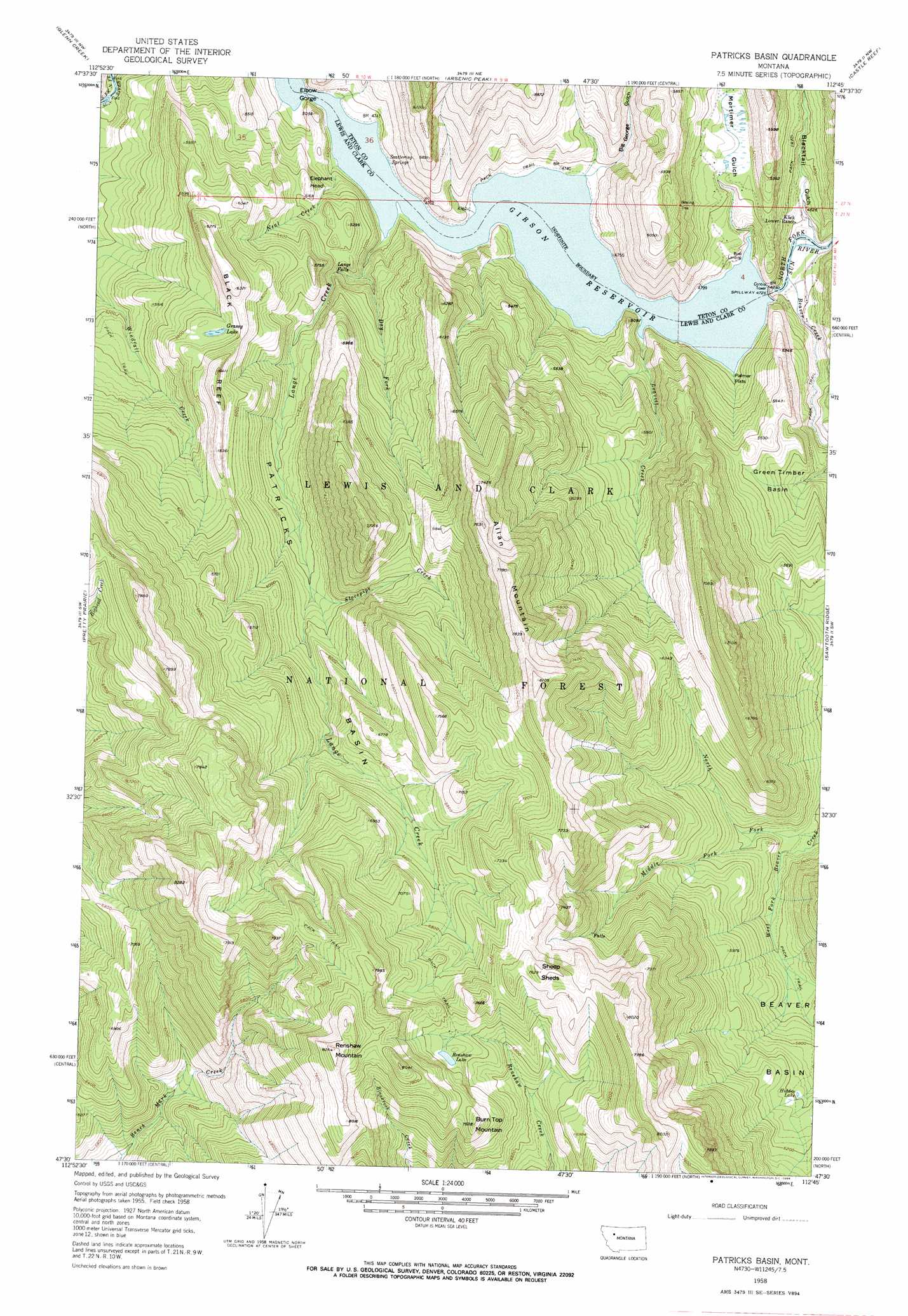
USGS Topo Quad 47112e7 - 1:24,000 scale
| Topo Map Name: | Patricks Basin |
| USGS Topo Quad ID: | 47112e7 |
| Print Size: | ca. 21 1/4" wide x 27" high |
| Southeast Coordinates: | 47.5° N latitude / 112.75° W longitude |
| Map Center Coordinates: | 47.5625° N latitude / 112.8125° W longitude |
| U.S. State: | MT |
| Filename: | o47112e7.jpg |
| Download Map JPG Image: | Patricks Basin topo map 1:24,000 scale |
| Map Type: | Topographic |
| Topo Series: | 7.5´ |
| Map Scale: | 1:24,000 |
| Source of Map Images: | United States Geological Survey (USGS) |
| Alternate Map Versions: |
Patricks Basin MT 1958, updated 1960 Download PDF Buy paper map Patricks Basin MT 1958, updated 1966 Download PDF Buy paper map Patricks Basin MT 1958, updated 1966 Download PDF Buy paper map Patricks Basin MT 1995, updated 1997 Download PDF Buy paper map Patricks Basin MT 2011 Download PDF Buy paper map Patricks Basin MT 2014 Download PDF Buy paper map |
| FStopo: | US Forest Service topo Patricks Basin is available: Download FStopo PDF Download FStopo TIF |
1:24,000 Topo Quads surrounding Patricks Basin
Three Sisters |
Gates Park |
Our Lake |
Ear Mountain |
Lake Theboe |
Slategoat Mountain |
Glenn Creek |
Arsenic Peak |
Castle Reef |
Split Rock Lake |
Prairie Reef |
Pretty Prairie |
Patricks Basin |
Sawtooth Ridge |
Barr Creek |
Trap Mountain |
Benchmark |
Wood Lake |
Double Falls |
Nilan Reservoir |
Danaher Mountain |
Flint Mountain |
Scapegoat Mountain |
Jakie Creek |
Steamboat Mountain |
> Back to 47112e1 at 1:100,000 scale
> Back to 47112a1 at 1:250,000 scale
> Back to U.S. Topo Maps home
Patricks Basin topo map: Gazetteer
Patricks Basin: Basins
Beaver Basin elevation 1758m 5767′Green Timber Basin elevation 1585m 5200′
Patricks Basin elevation 1778m 5833′
Patricks Basin: Dams
Gibson Dam elevation 1484m 4868′Patricks Basin: Falls
Lange Falls elevation 1530m 5019′Patricks Basin: Flats
Palmer Flats elevation 1455m 4773′Patricks Basin: Gaps
Elbow Gorge elevation 1442m 4730′Patricks Basin: Lakes
Grassy Lake elevation 1780m 5839′Hidden Lake elevation 1825m 5987′
Renshaw Lake elevation 2179m 7148′
Patricks Basin: Ranges
Black Reef elevation 1944m 6377′Patricks Basin: Reservoirs
Gibson Reservoir elevation 1484m 4868′Gibson Reservoir elevation 1405m 4609′
Patricks Basin: Springs
Scattering Springs elevation 1444m 4737′Patricks Basin: Streams
Beaver Creek elevation 1389m 4557′Dry Fork elevation 1472m 4829′
Lange Creek elevation 1444m 4737′
Leavitt Creek elevation 1446m 4744′
Middle Fork Beaver Creek elevation 1621m 5318′
Neal Creek elevation 1443m 4734′
North Fork Beaver Creek elevation 1587m 5206′
North Fork Sun River elevation 1441m 4727′
Stovepipe Creek elevation 1711m 5613′
West Fork Beaver Creek elevation 1584m 5196′
Patricks Basin: Summits
Allan Mountain elevation 2381m 7811′Burn Top Mountain elevation 2278m 7473′
Elephant Head elevation 1624m 5328′
Renshaw Mountain elevation 2518m 8261′
Sheep Sheds elevation 2322m 7618′
Patricks Basin: Valleys
Big George Gulch elevation 1456m 4776′Blacktail Gulch elevation 1401m 4596′
Mortimer Gulch elevation 1445m 4740′
Patricks Basin digital topo map on disk
Buy this Patricks Basin topo map showing relief, roads, GPS coordinates and other geographical features, as a high-resolution digital map file on DVD: