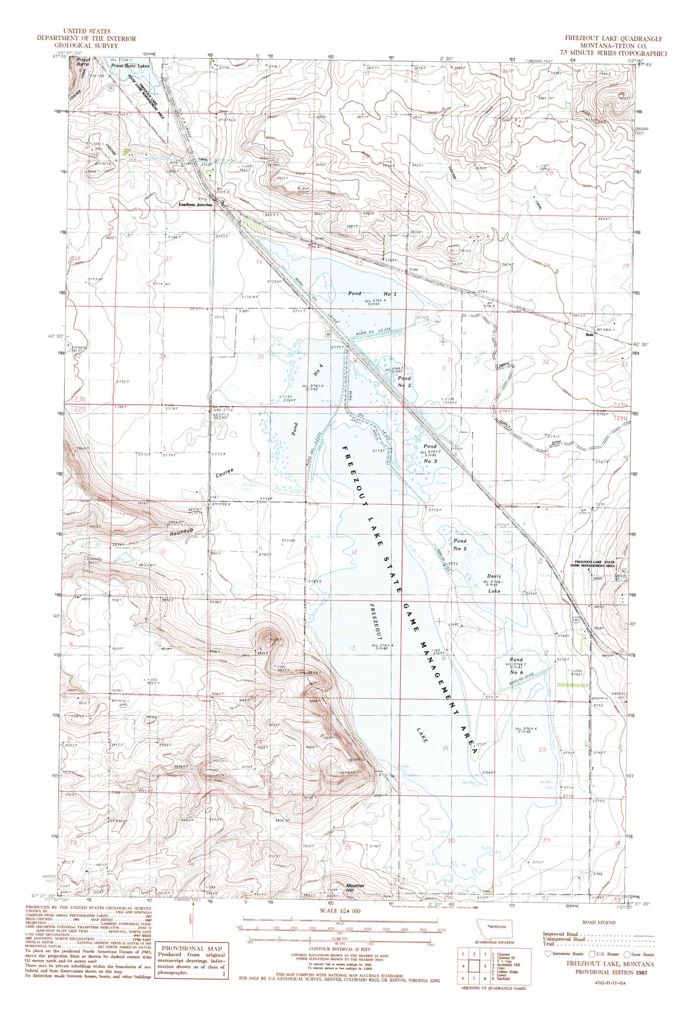
Freezeout Lake Topo Map Montana
To zoom in, hover over the map of Freezeout Lake
USGS Topo Quad 47112f1 - 1:24,000 scale
| Topo Map Name: | Freezeout Lake |
| USGS Topo Quad ID: | 47112f1 |
| Print Size: | ca. 21 1/4" wide x 27" high |
| Southeast Coordinates: | 47.625° N latitude / 112° W longitude |
| Map Center Coordinates: | 47.6875° N latitude / 112.0625° W longitude |
| U.S. State: | MT |
| Filename: | o47112f1.jpg |
| Download Map JPG Image: | Freezeout Lake topo map 1:24,000 scale |
| Map Type: | Topographic |
| Topo Series: | 7.5´ |
| Map Scale: | 1:24,000 |
| Source of Map Images: | United States Geological Survey (USGS) |
| Alternate Map Versions: |
Freezeout Lake MT 1987, updated 1987 Download PDF Buy paper map Freezeout Lake MT 2011 Download PDF Buy paper map Freezeout Lake MT 2014 Download PDF Buy paper map |
1:24,000 Topo Quads surrounding Freezeout Lake
Bynum |
Agawam South |
Eyraud Lakes |
Collins Nw |
Collins |
Teton Buttes |
Choteau |
Choteau Se |
T L Gap |
Collins Se |
Nunemaker Hill |
Sevenmile Hill |
Freezeout Lake |
Cleiv |
Greenfield |
Gilman |
Golden Ridge |
Lowry |
Fairfield |
Fort Shaw |
Gouchnour Ranch |
Bowmans Corners Nw |
Bowmans Corners Ne |
Simms |
Cascade Colony |
> Back to 47112e1 at 1:100,000 scale
> Back to 47112a1 at 1:250,000 scale
> Back to U.S. Topo Maps home
Freezeout Lake topo map: Gazetteer
Freezeout Lake: Canals
North Supply Ditch elevation 1155m 3789′Freezeout Lake: Lakes
Davis Lake elevation 1149m 3769′Freezeout Lake elevation 1148m 3766′
Pond Number Five elevation 1149m 3769′
Pond Number Four elevation 1149m 3769′
Pond Number One elevation 1150m 3772′
Pond Number Six elevation 1149m 3769′
Pond Number Three elevation 1149m 3769′
Pond Number Two elevation 1150m 3772′
Freezeout Lake: Populated Places
Bole elevation 1162m 3812′Eastham Junction elevation 1151m 3776′
Freezeout Lake: Post Offices
Bole Post Office (historical) elevation 1162m 3812′Green Post Office (historical) elevation 1159m 3802′
Freezeout Lake: Streams
Dipping Tank Creek elevation 1149m 3769′Freezeout Lake: Summits
Moehler Hill elevation 1192m 3910′Freezeout Lake: Valleys
Crossen Coulee elevation 1153m 3782′Floweree Coulee elevation 1151m 3776′
Road Coulee elevation 1147m 3763′
Roundup Coulee elevation 1157m 3795′
Wolf Coulee elevation 1147m 3763′
Freezeout Lake: Wells
22N03W08ABBA01 Well elevation 1154m 3786′22N03W09CDCD01 Well elevation 1200m 3937′
22N03W29AABA01 Well elevation 1151m 3776′
22N03W29AABA02 Well elevation 1151m 3776′
22N03W29AABA03 Well elevation 1151m 3776′
22N03W29AABA04 Well elevation 1151m 3776′
22N03W29D___01 Well elevation 1155m 3789′
22N03W31BCCD01 Well elevation 1154m 3786′
22N04W13B___01 Well elevation 1148m 3766′
23N03W30ABDC01 Well elevation 1169m 3835′
23N04W24C___01 Well elevation 1194m 3917′
Freezeout Lake digital topo map on disk
Buy this Freezeout Lake topo map showing relief, roads, GPS coordinates and other geographical features, as a high-resolution digital map file on DVD: