Castle Reef Topo Map Montana
To zoom in, hover over the map of Castle Reef
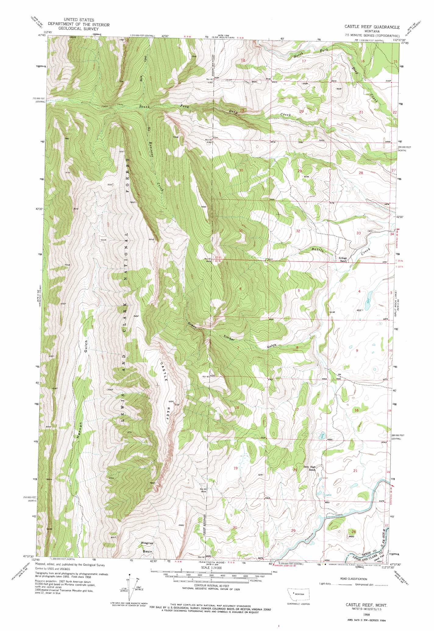
USGS Topo Quad 47112f6 - 1:24,000 scale
| Topo Map Name: | Castle Reef |
| USGS Topo Quad ID: | 47112f6 |
| Print Size: | ca. 21 1/4" wide x 27" high |
| Southeast Coordinates: | 47.625° N latitude / 112.625° W longitude |
| Map Center Coordinates: | 47.6875° N latitude / 112.6875° W longitude |
| U.S. State: | MT |
| Filename: | o47112f6.jpg |
| Download Map JPG Image: | Castle Reef topo map 1:24,000 scale |
| Map Type: | Topographic |
| Topo Series: | 7.5´ |
| Map Scale: | 1:24,000 |
| Source of Map Images: | United States Geological Survey (USGS) |
| Alternate Map Versions: |
Castle Reef MT 1958, updated 1960 Download PDF Buy paper map Castle Reef MT 1958, updated 1975 Download PDF Buy paper map Castle Reef MT 1995, updated 1997 Download PDF Buy paper map Castle Reef MT 2011 Download PDF Buy paper map Castle Reef MT 2014 Download PDF Buy paper map |
| FStopo: | US Forest Service topo Castle Reef is available: Download FStopo PDF Download FStopo TIF |
1:24,000 Topo Quads surrounding Castle Reef
Porphyry Reef |
Mount Wright |
Cave Mountain |
Twin Lakes |
Bynum Reservoir |
Gates Park |
Our Lake |
Ear Mountain |
Lake Theboe |
Watson Flats |
Glenn Creek |
Arsenic Peak |
Castle Reef |
Split Rock Lake |
Pishkun Reservoir |
Pretty Prairie |
Patricks Basin |
Sawtooth Ridge |
Barr Creek |
Split Rock Junction |
Benchmark |
Wood Lake |
Double Falls |
Nilan Reservoir |
Augusta |
> Back to 47112e1 at 1:100,000 scale
> Back to 47112a1 at 1:250,000 scale
> Back to U.S. Topo Maps home
Castle Reef topo map: Gazetteer
Castle Reef: Basins
Wagner Basin elevation 1476m 4842′Castle Reef: Post Offices
Elizabeth Post Office (historical) elevation 1473m 4832′Castle Reef: Streams
Erosion Creek elevation 1795m 5889′Falls Creek elevation 1306m 4284′
Francis Creek elevation 1383m 4537′
No Business Creek elevation 1715m 5626′
Rain Creek elevation 1719m 5639′
Richardson Creek elevation 1367m 4484′
Castle Reef: Summits
Castle Reef elevation 2538m 8326′Grass Hill elevation 2485m 8152′
Castle Reef: Valleys
Green Timber Gulch elevation 1513m 4963′Castle Reef digital topo map on disk
Buy this Castle Reef topo map showing relief, roads, GPS coordinates and other geographical features, as a high-resolution digital map file on DVD: