Our Lake Topo Map Montana
To zoom in, hover over the map of Our Lake
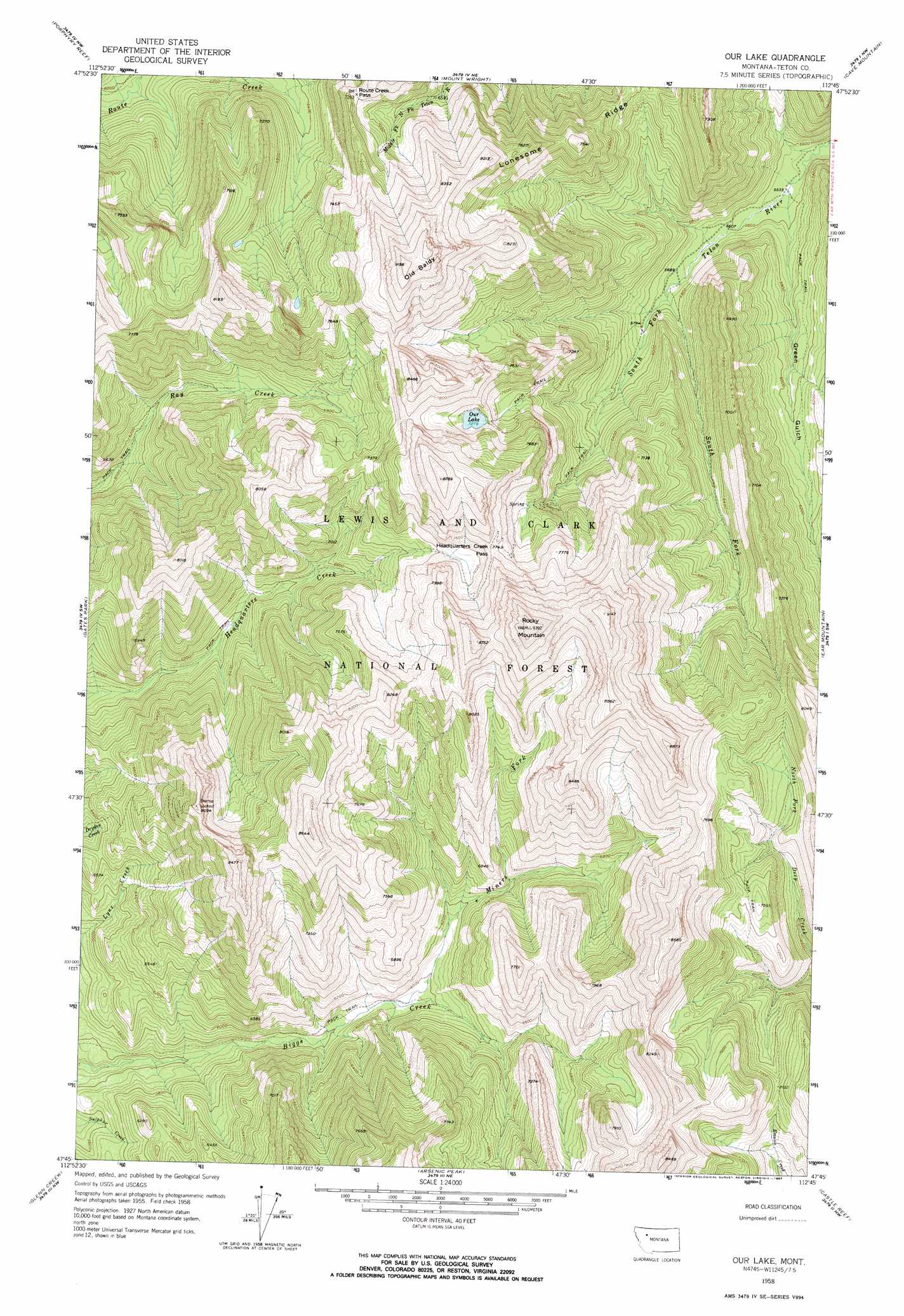
USGS Topo Quad 47112g7 - 1:24,000 scale
| Topo Map Name: | Our Lake |
| USGS Topo Quad ID: | 47112g7 |
| Print Size: | ca. 21 1/4" wide x 27" high |
| Southeast Coordinates: | 47.75° N latitude / 112.75° W longitude |
| Map Center Coordinates: | 47.8125° N latitude / 112.8125° W longitude |
| U.S. State: | MT |
| Filename: | o47112g7.jpg |
| Download Map JPG Image: | Our Lake topo map 1:24,000 scale |
| Map Type: | Topographic |
| Topo Series: | 7.5´ |
| Map Scale: | 1:24,000 |
| Source of Map Images: | United States Geological Survey (USGS) |
| Alternate Map Versions: |
Our Lake MT 1958, updated 1959 Download PDF Buy paper map Our Lake MT 1958, updated 1967 Download PDF Buy paper map Our Lake MT 1958, updated 1967 Download PDF Buy paper map Our Lake MT 1995, updated 1997 Download PDF Buy paper map Our Lake MT 1995, updated 1997 Download PDF Buy paper map Our Lake MT 2011 Download PDF Buy paper map Our Lake MT 2014 Download PDF Buy paper map |
| FStopo: | US Forest Service topo Our Lake is available: Download FStopo PDF Download FStopo TIF |
1:24,000 Topo Quads surrounding Our Lake
Gooseberry Peak |
Gateway Pass |
Walling Reef |
Volcano Reef |
Blackleaf |
Pentagon Mountain |
Porphyry Reef |
Mount Wright |
Cave Mountain |
Twin Lakes |
Three Sisters |
Gates Park |
Our Lake |
Ear Mountain |
Lake Theboe |
Slategoat Mountain |
Glenn Creek |
Arsenic Peak |
Castle Reef |
Split Rock Lake |
Prairie Reef |
Pretty Prairie |
Patricks Basin |
Sawtooth Ridge |
Barr Creek |
> Back to 47112e1 at 1:100,000 scale
> Back to 47112a1 at 1:250,000 scale
> Back to U.S. Topo Maps home
Our Lake topo map: Gazetteer
Our Lake: Falls
Mill Falls elevation 1762m 5780′Our Lake: Gaps
Headquarters Creek Pass elevation 2362m 7749′Route Creek Pass elevation 2216m 7270′
Our Lake: Lakes
Our Lake elevation 2220m 7283′Our Lake: Ranges
Sawtooth Range elevation 2401m 7877′Our Lake: Streams
Miners Fork elevation 1811m 5941′South Fork South Fork Teton River elevation 1746m 5728′
Our Lake: Summits
Old Baldy elevation 2769m 9084′Rocky Mountain elevation 2858m 9376′
Our Lake: Valleys
Green Gulch elevation 1688m 5538′Our Lake digital topo map on disk
Buy this Our Lake topo map showing relief, roads, GPS coordinates and other geographical features, as a high-resolution digital map file on DVD: