Salmon Lake Topo Map Montana
To zoom in, hover over the map of Salmon Lake
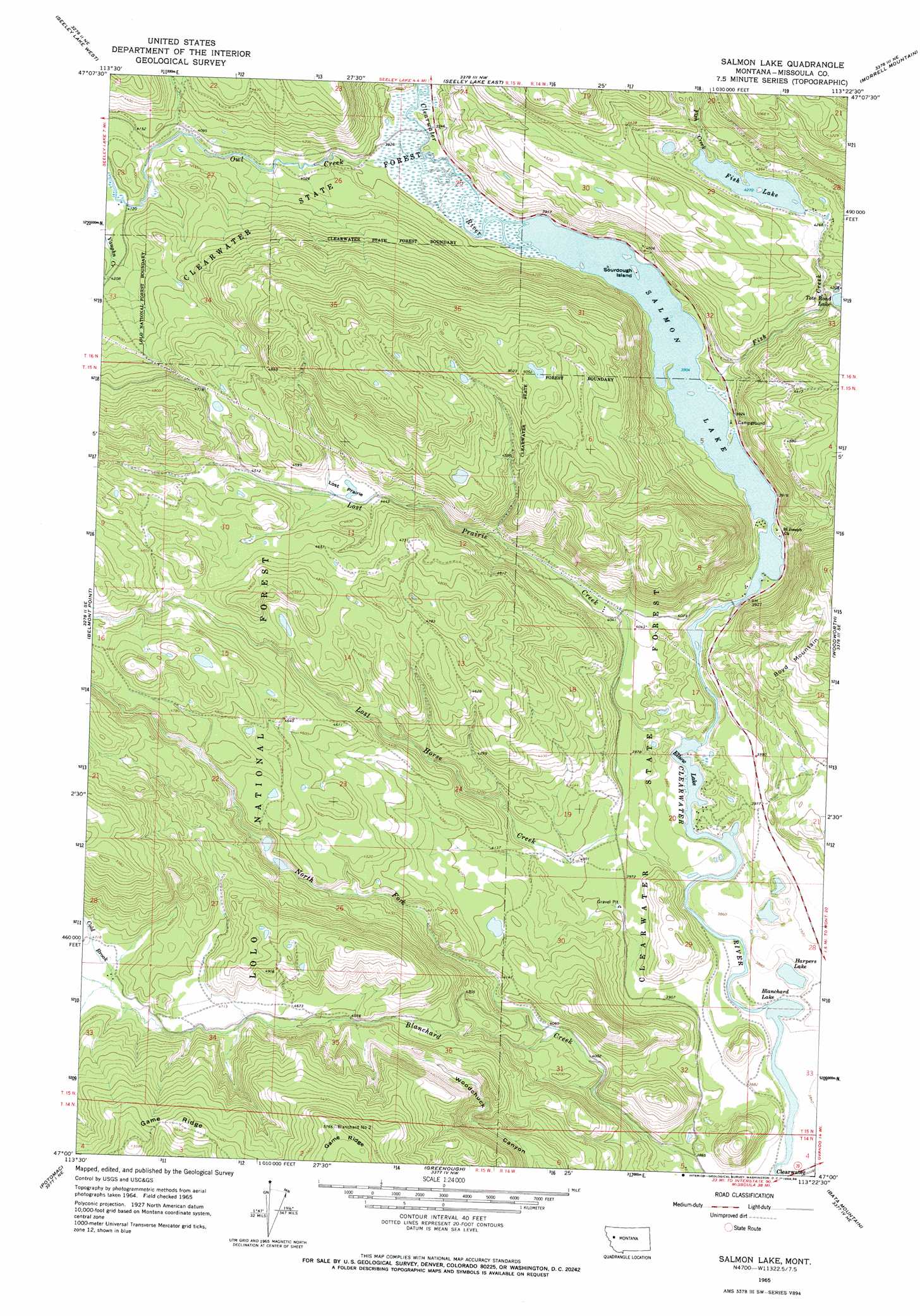
USGS Topo Quad 47113a4 - 1:24,000 scale
| Topo Map Name: | Salmon Lake |
| USGS Topo Quad ID: | 47113a4 |
| Print Size: | ca. 21 1/4" wide x 27" high |
| Southeast Coordinates: | 47° N latitude / 113.375° W longitude |
| Map Center Coordinates: | 47.0625° N latitude / 113.4375° W longitude |
| U.S. State: | MT |
| Filename: | o47113a4.jpg |
| Download Map JPG Image: | Salmon Lake topo map 1:24,000 scale |
| Map Type: | Topographic |
| Topo Series: | 7.5´ |
| Map Scale: | 1:24,000 |
| Source of Map Images: | United States Geological Survey (USGS) |
| Alternate Map Versions: |
Salmon Lake MT 1965, updated 1968 Download PDF Buy paper map Salmon Lake MT 1965, updated 1986 Download PDF Buy paper map Salmon Lake MT 1999, updated 2003 Download PDF Buy paper map Salmon Lake MT 2011 Download PDF Buy paper map Salmon Lake MT 2014 Download PDF Buy paper map |
| FStopo: | US Forest Service topo Salmon Lake is available: Download FStopo PDF Download FStopo TIF |
1:24,000 Topo Quads surrounding Salmon Lake
Lake Marshall |
Lake Inez |
Morrell Lake |
Crimson Peak |
Hahn Creek Pass |
Upper Jocko Lake |
Seeley Lake West |
Seeley Lake East |
Morrell Mountain |
Dunham Point |
Gold Creek Peak |
Belmont Point |
Salmon Lake |
Woodworth |
Ovando |
Sunflower Mountain |
Potomac |
Greenough |
Bata Mountain |
Chamberlain Mountain |
Clinton |
Mineral Ridge |
Union Peak |
Elevation Mountain |
Wild Horse Parks |
> Back to 47113a1 at 1:100,000 scale
> Back to 47112a1 at 1:250,000 scale
> Back to U.S. Topo Maps home
Salmon Lake topo map: Gazetteer
Salmon Lake: Airports
Sourdough Island on Salmon Lake Heliport elevation 1397m 4583′Salmon Lake: Flats
Lost Prairie elevation 1362m 4468′Salmon Lake: Islands
Sourdough Island elevation 1198m 3930′Salmon Lake: Lakes
Big Sky Lake elevation 1303m 4274′Blanchard Lake elevation 1165m 3822′
Elbow Lake elevation 1171m 3841′
Harpers Lake elevation 1165m 3822′
Harpers Lake elevation 1175m 3854′
Salmon Lake elevation 1211m 3973′
Salmon Lake elevation 1191m 3907′
Salmon Lake: Parks
Salmon Lake State Park elevation 1199m 3933′Salmon Lake: Populated Places
Clearwater elevation 1166m 3825′Salmon Lake: Post Offices
Clearwater Post Office (historical) elevation 1167m 3828′Salmon Lake: Streams
Cold Brook elevation 1432m 4698′Fish Creek elevation 1191m 3907′
Lost Horse Creek elevation 1172m 3845′
Lost Prairie Creek elevation 1171m 3841′
North Fork Blanchard Creek elevation 1235m 4051′
Owl Creek elevation 1196m 3923′
Salmon Lake: Summits
Boyd Mountain elevation 1500m 4921′Salmon Lake: Wells
15N14W05ABAB01 Well elevation 1201m 3940′15N14W09BBCA01 Well elevation 1203m 3946′
15N14W09CBBC01 Well elevation 1198m 3930′
Salmon Lake digital topo map on disk
Buy this Salmon Lake topo map showing relief, roads, GPS coordinates and other geographical features, as a high-resolution digital map file on DVD: