Hahn Creek Pass Topo Map Montana
To zoom in, hover over the map of Hahn Creek Pass
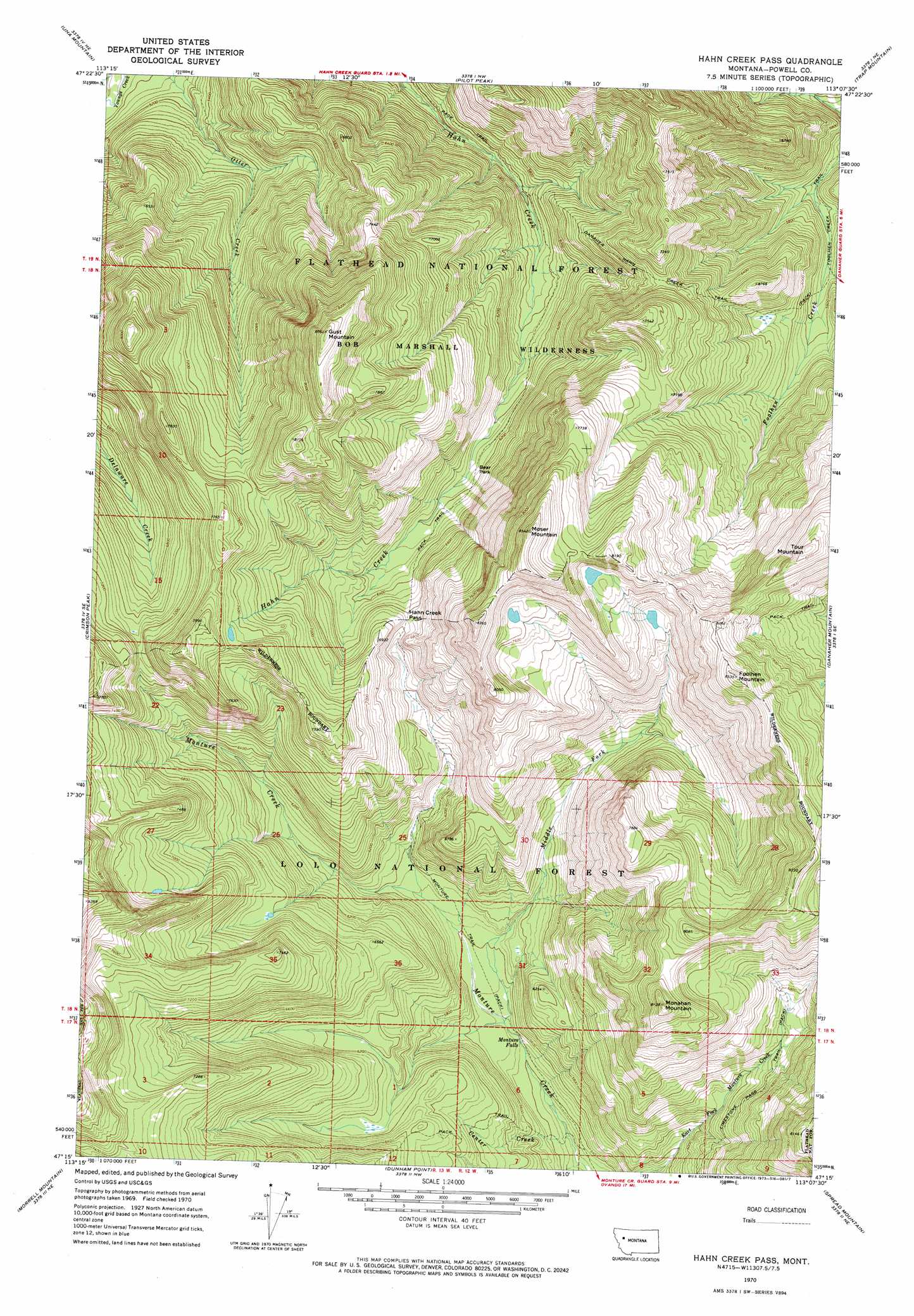
USGS Topo Quad 47113c2 - 1:24,000 scale
| Topo Map Name: | Hahn Creek Pass |
| USGS Topo Quad ID: | 47113c2 |
| Print Size: | ca. 21 1/4" wide x 27" high |
| Southeast Coordinates: | 47.25° N latitude / 113.125° W longitude |
| Map Center Coordinates: | 47.3125° N latitude / 113.1875° W longitude |
| U.S. State: | MT |
| Filename: | o47113c2.jpg |
| Download Map JPG Image: | Hahn Creek Pass topo map 1:24,000 scale |
| Map Type: | Topographic |
| Topo Series: | 7.5´ |
| Map Scale: | 1:24,000 |
| Source of Map Images: | United States Geological Survey (USGS) |
| Alternate Map Versions: |
Hahn Creek Pass MT 1970, updated 1973 Download PDF Buy paper map Hahn Creek Pass MT 1999, updated 2003 Download PDF Buy paper map Hahn Creek Pass MT 2011 Download PDF Buy paper map Hahn Creek Pass MT 2014 Download PDF Buy paper map |
| FStopo: | US Forest Service topo Hahn Creek Pass is available: Download FStopo PDF Download FStopo TIF |
1:24,000 Topo Quads surrounding Hahn Creek Pass
Big Salmon Lake West |
Big Salmon Lake East |
Haystack Mountain |
Prairie Reef |
Pretty Prairie |
Shaw Creek |
Una Mountain |
Pilot Peak |
Trap Mountain |
Benchmark |
Morrell Lake |
Crimson Peak |
Hahn Creek Pass |
Danaher Mountain |
Flint Mountain |
Seeley Lake East |
Morrell Mountain |
Dunham Point |
Spread Mountain |
Lake Mountain |
Salmon Lake |
Woodworth |
Ovando |
Ovando Mountain |
Coopers Lake |
> Back to 47113a1 at 1:100,000 scale
> Back to 47112a1 at 1:250,000 scale
> Back to U.S. Topo Maps home
Hahn Creek Pass topo map: Gazetteer
Hahn Creek Pass: Falls
Monture Falls elevation 1661m 5449′Hahn Creek Pass: Flats
Bear Park elevation 1861m 6105′Hahn Creek Pass: Gaps
Hahn Creek Pass elevation 2037m 6683′Hahn Creek Pass: Streams
Center Creek elevation 1610m 5282′Middle Fork Monture Creek elevation 1675m 5495′
Hahn Creek Pass: Summits
Foolhen Mountain elevation 2600m 8530′Gust Mountain elevation 2589m 8494′
Monahan Mountain elevation 2479m 8133′
Moser Mountain elevation 2572m 8438′
Tour Mountain elevation 2528m 8293′
Hahn Creek Pass: Trails
Center Creek Trail elevation 1932m 6338′Foolhen Creek Trail elevation 1713m 5620′
Limestone Pass Trail elevation 2029m 6656′
Monture Trail elevation 1699m 5574′
Hahn Creek Pass digital topo map on disk
Buy this Hahn Creek Pass topo map showing relief, roads, GPS coordinates and other geographical features, as a high-resolution digital map file on DVD: