Tin Creek Topo Map Montana
To zoom in, hover over the map of Tin Creek
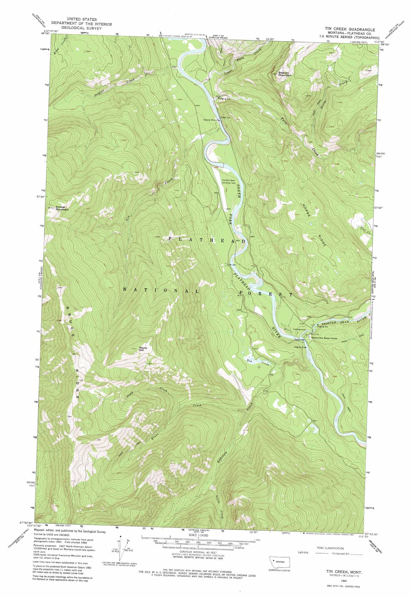
USGS Topo Quad 47113h5 - 1:24,000 scale
| Topo Map Name: | Tin Creek |
| USGS Topo Quad ID: | 47113h5 |
| Print Size: | ca. 21 1/4" wide x 27" high |
| Southeast Coordinates: | 47.875° N latitude / 113.5° W longitude |
| Map Center Coordinates: | 47.9375° N latitude / 113.5625° W longitude |
| U.S. State: | MT |
| Filename: | o47113h5.jpg |
| Download Map JPG Image: | Tin Creek topo map 1:24,000 scale |
| Map Type: | Topographic |
| Topo Series: | 7.5´ |
| Map Scale: | 1:24,000 |
| Source of Map Images: | United States Geological Survey (USGS) |
| Alternate Map Versions: |
Tin Creek MT 1965, updated 1968 Download PDF Buy paper map Tin Creek MT 1965, updated 1980 Download PDF Buy paper map Tin Creek MT 1994, updated 1997 Download PDF Buy paper map Tin Creek MT 2011 Download PDF Buy paper map Tin Creek MT 2014 Download PDF Buy paper map |
| FStopo: | US Forest Service topo Tin Creek is available: Download FStopo PDF Download FStopo TIF |
1:24,000 Topo Quads surrounding Tin Creek
Pioneer Ridge |
Felix Peak |
Nimrod |
Mount Bradley |
Red Plume Mountain |
Big Hawk Mountain |
Quintonkon |
Circus Peak |
Horseshoe Peak |
Capitol Mountain |
Swan Lake |
Connor Creek |
Tin Creek |
Spotted Bear Mountain |
Whitcomb Peak |
Cilly Creek |
Thunderbolt Mountain |
String Creek |
Meadow Creek |
Cathedral Peak |
Salmon Prairie |
Swan Peak |
Sunburst Lake |
Marmot Mountain |
Pagoda Mountain |
> Back to 47113e1 at 1:100,000 scale
> Back to 47112a1 at 1:250,000 scale
> Back to U.S. Topo Maps home
Tin Creek topo map: Gazetteer
Tin Creek: Airports
Spotted Bear-US Forest Service Airport elevation 1130m 3707′Tin Creek: Bridges
Billy R Garrett Memorial Bridge elevation 1109m 3638′Tin Creek: Flats
Bruce Meadows elevation 1244m 4081′Tin Creek: Ridges
Bruce Ridge elevation 2212m 7257′Horse Ridge elevation 1494m 4901′
Tin Creek: Streams
Addition Creek elevation 1120m 3674′Bruce Creek elevation 1251m 4104′
Little Creek elevation 1385m 4543′
Lower Twin Creek elevation 1098m 3602′
North Creek elevation 1146m 3759′
Red Creek elevation 1171m 3841′
Soldier Creek elevation 1092m 3582′
Spotted Bear River elevation 1122m 3681′
Stony Creek elevation 1384m 4540′
Tin Creek elevation 1097m 3599′
Twin Creek elevation 1099m 3605′
Tin Creek: Summits
Beacon Mountain elevation 1619m 5311′Soldier Mountain elevation 2005m 6578′
Stony Hill elevation 2175m 7135′
Tin Creek digital topo map on disk
Buy this Tin Creek topo map showing relief, roads, GPS coordinates and other geographical features, as a high-resolution digital map file on DVD: