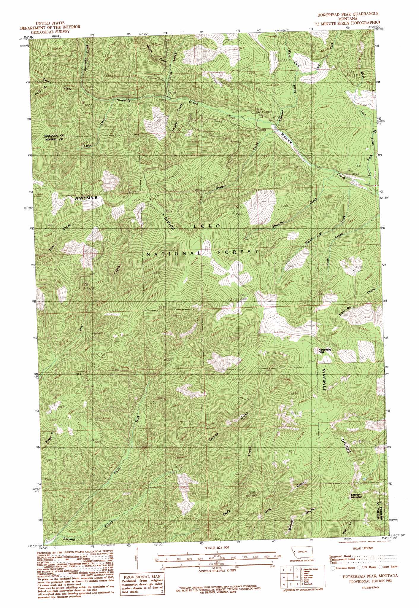
Horsehead Peak Topo Map Montana
To zoom in, hover over the map of Horsehead Peak
USGS Topo Quad 47114b6 - 1:24,000 scale
| Topo Map Name: | Horsehead Peak |
| USGS Topo Quad ID: | 47114b6 |
| Print Size: | ca. 21 1/4" wide x 27" high |
| Southeast Coordinates: | 47.125° N latitude / 114.625° W longitude |
| Map Center Coordinates: | 47.1875° N latitude / 114.6875° W longitude |
| U.S. State: | MT |
| Filename: | o47114b6.jpg |
| Download Map JPG Image: | Horsehead Peak topo map 1:24,000 scale |
| Map Type: | Topographic |
| Topo Series: | 7.5´ |
| Map Scale: | 1:24,000 |
| Source of Map Images: | United States Geological Survey (USGS) |
| Alternate Map Versions: |
Horsehead Peak MT 1983, updated 1984 Download PDF Buy paper map Horsehead Peak MT 1999, updated 2003 Download PDF Buy paper map Horsehead Peak MT 2011 Download PDF Buy paper map Horsehead Peak MT 2014 Download PDF Buy paper map |
| FStopo: | US Forest Service topo Horsehead Peak is available: Download FStopo PDF Download FStopo TIF |
1:24,000 Topo Quads surrounding Horsehead Peak
Plains |
Paradise |
Sunrise Spring |
Camas Prairie |
Melton Ranch |
Keystone Peak |
Quinns Hot Springs |
Knowles |
Perma |
Mcdonald |
Superior |
Idaho Gulch |
Horsehead Peak |
Stark North |
Mccormick Peak |
Landowner Mountain |
Lozeau |
Tarkio |
Stark South |
Alberton |
Straight Peak |
Saint Patrick Peak |
Williams Peak |
Deer Peak |
Petty Mountain |
> Back to 47114a1 at 1:100,000 scale
> Back to 47114a1 at 1:250,000 scale
> Back to U.S. Topo Maps home
Horsehead Peak topo map: Gazetteer
Horsehead Peak: Mines
D J Silver/Saint Louis Mine elevation 1352m 4435′Frances Copper Mine elevation 1327m 4353′
Granite Number 2 Mine elevation 1525m 5003′
Liquidator Mine elevation 1650m 5413′
Liquidator Number 2 Mine elevation 1649m 5410′
Lookout Fraction Number 3 Mine elevation 1629m 5344′
Lower Eddy Creek Mine elevation 1472m 4829′
Lower Ninemile Mine elevation 1405m 4609′
Lucy Ellen Mine elevation 1575m 5167′
Martina Creek Mine elevation 1359m 4458′
Martina Mine elevation 1645m 5396′
Ninemile Creek Mine elevation 1208m 3963′
Ninemile Mine elevation 1487m 4878′
Upper Eddy Creek Mine elevation 1502m 4927′
Upper Ninemile Mine elevation 1584m 5196′
War Eagle Mine elevation 1930m 6332′
Horsehead Peak: Populated Places
Old Town elevation 1279m 4196′Horsehead Peak: Post Offices
Martina Post Office (historical) elevation 1249m 4097′Horsehead Peak: Streams
Antelope Creek elevation 1416m 4645′Beecher Creek elevation 1208m 3963′
Devils Creek elevation 1325m 4347′
East Fork Beecher Creek elevation 1289m 4229′
East Fork Burnt Fork Creek elevation 1223m 4012′
Eustache Creek elevation 1325m 4347′
Martina Creek elevation 1174m 3851′
Mattie V Creek elevation 1167m 3828′
North Fork Second Creek elevation 942m 3090′
Nugget Creek elevation 1251m 4104′
Oliver Creek elevation 1376m 4514′
Pats Creek elevation 1225m 4019′
Queue Creek elevation 1296m 4251′
Saint Louis Creek elevation 1257m 4124′
Sawpit Creek elevation 1209m 3966′
Sparks Creek elevation 1292m 4238′
West Fork Beecher Creek elevation 1289m 4229′
West Fork Burnt Fork Creek elevation 1223m 4012′
Horsehead Peak: Summits
Horsehead Peak elevation 2040m 6692′Lookout Mountain elevation 2159m 7083′
Horsehead Peak digital topo map on disk
Buy this Horsehead Peak topo map showing relief, roads, GPS coordinates and other geographical features, as a high-resolution digital map file on DVD: