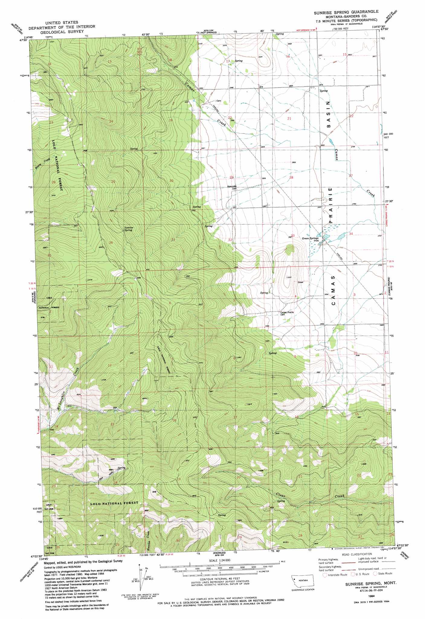
Sunrise Spring Topo Map Montana
To zoom in, hover over the map of Sunrise Spring
USGS Topo Quad 47114d6 - 1:24,000 scale
| Topo Map Name: | Sunrise Spring |
| USGS Topo Quad ID: | 47114d6 |
| Print Size: | ca. 21 1/4" wide x 27" high |
| Southeast Coordinates: | 47.375° N latitude / 114.625° W longitude |
| Map Center Coordinates: | 47.4375° N latitude / 114.6875° W longitude |
| U.S. State: | MT |
| Filename: | o47114d6.jpg |
| Download Map JPG Image: | Sunrise Spring topo map 1:24,000 scale |
| Map Type: | Topographic |
| Topo Series: | 7.5´ |
| Map Scale: | 1:24,000 |
| Source of Map Images: | United States Geological Survey (USGS) |
| Alternate Map Versions: |
Sunrise Spring MT 1984, updated 1984 Download PDF Buy paper map Sunrise Spring MT 1999, updated 2003 Download PDF Buy paper map Sunrise Spring MT 2011 Download PDF Buy paper map Sunrise Spring MT 2014 Download PDF Buy paper map |
| FStopo: | US Forest Service topo Sunrise Spring is available: Download FStopo PDF Download FStopo TIF |
1:24,000 Topo Quads surrounding Sunrise Spring
Loneman Creek |
Coney Peak |
Lonepine |
Hot Springs Ne |
Irvine Hill |
Weeksville |
Baldy Lake |
Hot Springs |
Markle Pass |
Oliver Point |
Plains |
Paradise |
Sunrise Spring |
Camas Prairie |
Melton Ranch |
Keystone Peak |
Quinns Hot Springs |
Knowles |
Perma |
Mcdonald |
Superior |
Idaho Gulch |
Horsehead Peak |
Stark North |
Mccormick Peak |
> Back to 47114a1 at 1:100,000 scale
> Back to 47114a1 at 1:250,000 scale
> Back to U.S. Topo Maps home
Sunrise Spring topo map: Gazetteer
Sunrise Spring: Post Offices
Greenspring Post Office (historical) elevation 855m 2805′Sunrise Spring: Springs
Green Springs elevation 856m 2808′Sunrise Spring elevation 1338m 4389′
Sunrise Spring: Wells
19N24W03CCDD01 Well elevation 875m 2870′19N24W03CDC_01 Well elevation 884m 2900′
19N24W04AADB01 Well elevation 872m 2860′
19N24W04CACA01 Well elevation 936m 3070′
19N24W10BBAB01 Well elevation 892m 2926′
19N24W10BCBC01 Well elevation 909m 2982′
19N24W10BCC_01 Well elevation 919m 3015′
20N24W15BBBB01 Well elevation 870m 2854′
20N24W15CBB_01 Well elevation 863m 2831′
20N24W18DDAC01 Well elevation 945m 3100′
20N24W19AAAA01 Well elevation 934m 3064′
20N24W21AAA_01 Well elevation 860m 2821′
20N24W21AAA_02 Well elevation 860m 2821′
20N24W22AAB_01 Well elevation 856m 2808′
20N24W28DDC_01 Well elevation 855m 2805′
20N24W29CDCD01 Well elevation 917m 3008′
20N24W29CDDD01 Well elevation 903m 2962′
20N24W29DADD01 Well elevation 869m 2851′
20N24W34AAAB01 Well elevation 847m 2778′
20N24W34AAC_01 Well elevation 847m 2778′
20N24W34BAB_01 Well elevation 852m 2795′
20N24W34DCC_01 Well elevation 856m 2808′
Sunrise Spring digital topo map on disk
Buy this Sunrise Spring topo map showing relief, roads, GPS coordinates and other geographical features, as a high-resolution digital map file on DVD: