Bathtub Mountain Topo Map Idaho
To zoom in, hover over the map of Bathtub Mountain
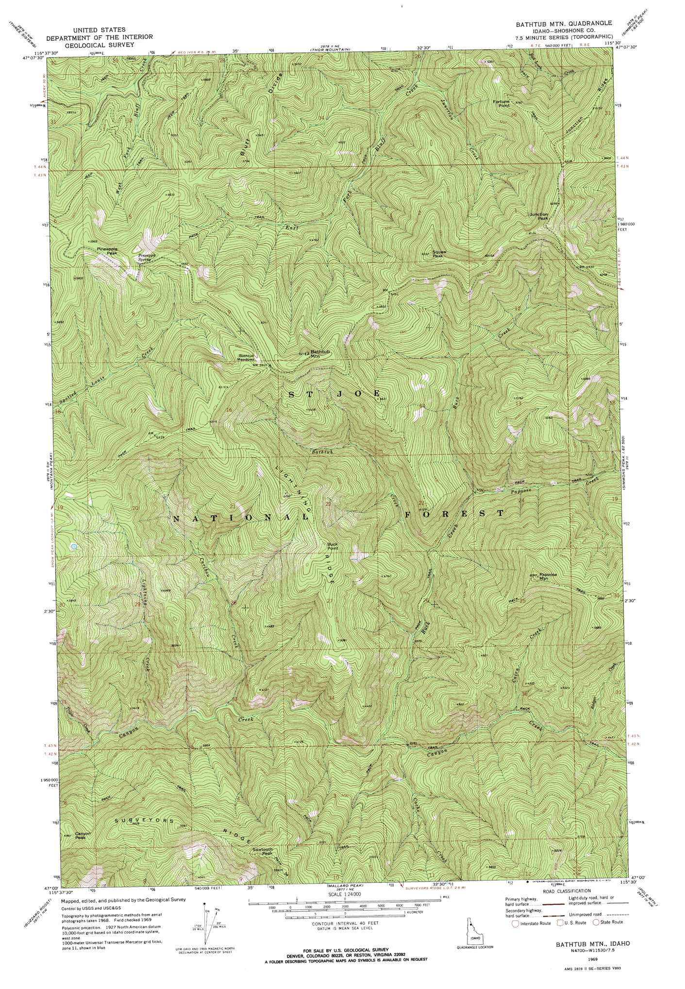
USGS Topo Quad 47115a5 - 1:24,000 scale
| Topo Map Name: | Bathtub Mountain |
| USGS Topo Quad ID: | 47115a5 |
| Print Size: | ca. 21 1/4" wide x 27" high |
| Southeast Coordinates: | 47° N latitude / 115.5° W longitude |
| Map Center Coordinates: | 47.0625° N latitude / 115.5625° W longitude |
| U.S. State: | ID |
| Filename: | o47115a5.jpg |
| Download Map JPG Image: | Bathtub Mountain topo map 1:24,000 scale |
| Map Type: | Topographic |
| Topo Series: | 7.5´ |
| Map Scale: | 1:24,000 |
| Source of Map Images: | United States Geological Survey (USGS) |
| Alternate Map Versions: |
Bathtub Mtn ID 1969, updated 1973 Download PDF Buy paper map Bathtub Mountain ID 1995, updated 1997 Download PDF Buy paper map Bathtub Mountain ID 2011 Download PDF Buy paper map Bathtub Mountain ID 2013 Download PDF Buy paper map |
| FStopo: | US Forest Service topo Bathtub Mountain is available: Download FStopo PDF Download FStopo TIF |
1:24,000 Topo Quads surrounding Bathtub Mountain
Avery |
Shefoot Mountain |
Adair |
Mcgee Peak |
Deborgia South |
Fishhook Creek |
Three Sisters |
Thor Mountain |
Conrad Peak |
Berge Peak |
Monumental Buttes |
Montana Peak |
Bathtub Mountain |
Peggy Peak |
Red Ives Peak |
Little Goat Mountains |
Buzzard Roost |
Mallard Peak |
Pole Mountain |
Bacon Peak |
Bertha Hill |
Thompson Point |
Sheep Mountain |
The Nub |
Elizabeth Lake |
> Back to 47115a1 at 1:100,000 scale
> Back to 47114a1 at 1:250,000 scale
> Back to U.S. Topo Maps home
Bathtub Mountain topo map: Gazetteer
Bathtub Mountain: Flats
Bathtub Meadows elevation 1776m 5826′Bathtub Mountain: Ridges
Lightning Ridge elevation 1662m 5452′Bathtub Mountain: Springs
Pineapple Spring elevation 1790m 5872′Bathtub Mountain: Streams
Badger Creek elevation 1219m 3999′Bathtub Creek elevation 1108m 3635′
Buck Creek elevation 1046m 3431′
Cache Creek elevation 1076m 3530′
Cairn Creek elevation 1153m 3782′
Caribou Creek elevation 969m 3179′
Junction Creek elevation 1209m 3966′
Lightning Creek elevation 956m 3136′
Papoose Creek elevation 1144m 3753′
Triple Creek elevation 898m 2946′
Bathtub Mountain: Summits
Bathtub Mountain elevation 1895m 6217′Buck Point elevation 1675m 5495′
Canyon Peak elevation 1512m 4960′
Fortune Point elevation 1759m 5770′
Junction Peak elevation 1917m 6289′
Papoose Mountain elevation 1852m 6076′
Pineapple Peak elevation 1844m 6049′
Sawtooth Peak elevation 1795m 5889′
Spotwean Peak elevation 1912m 6272′
Bathtub Mountain digital topo map on disk
Buy this Bathtub Mountain topo map showing relief, roads, GPS coordinates and other geographical features, as a high-resolution digital map file on DVD: