Lookout Pass Topo Map Idaho
To zoom in, hover over the map of Lookout Pass
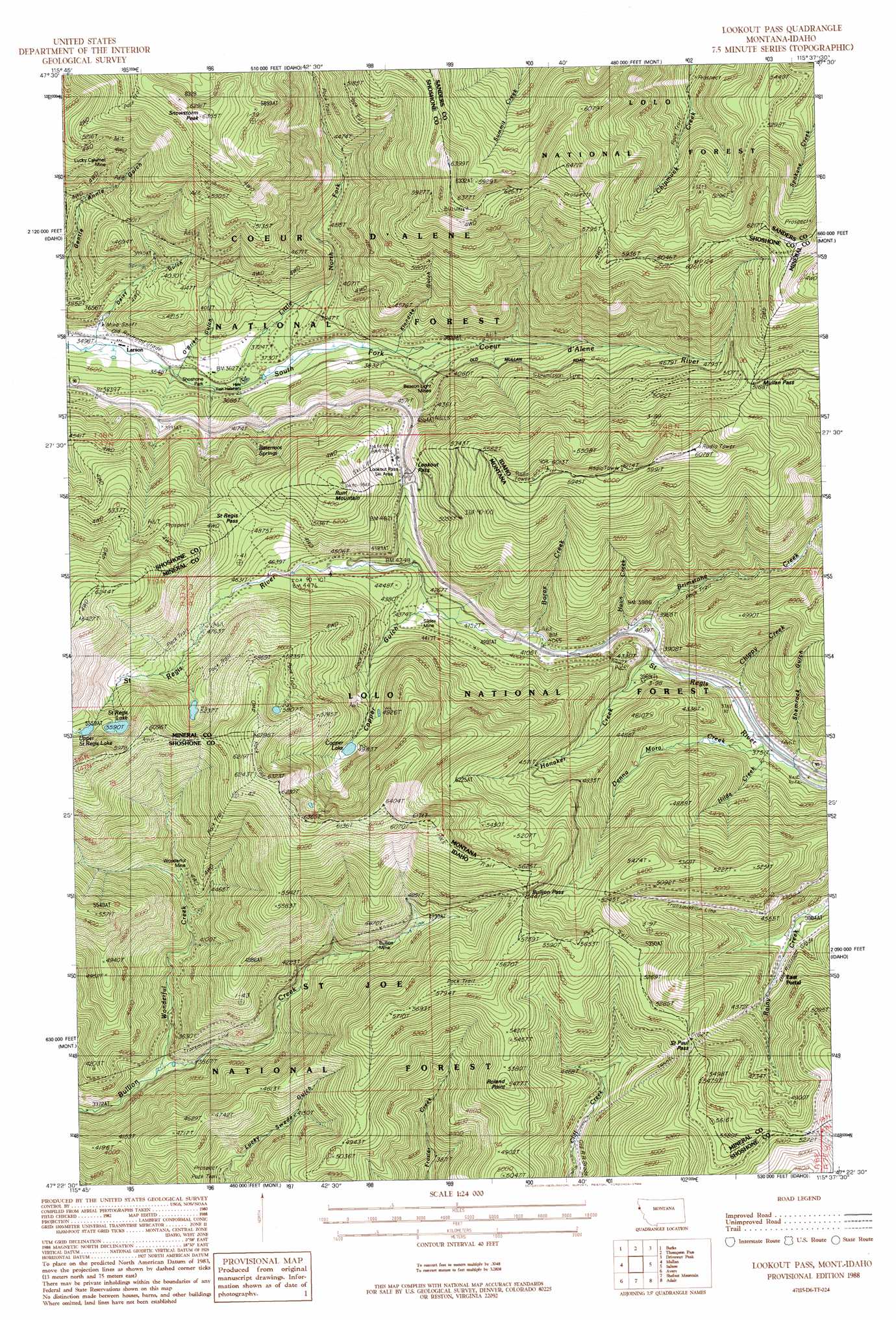
USGS Topo Quad 47115d6 - 1:24,000 scale
| Topo Map Name: | Lookout Pass |
| USGS Topo Quad ID: | 47115d6 |
| Print Size: | ca. 21 1/4" wide x 27" high |
| Southeast Coordinates: | 47.375° N latitude / 115.625° W longitude |
| Map Center Coordinates: | 47.4375° N latitude / 115.6875° W longitude |
| U.S. States: | ID, MT |
| Filename: | o47115d6.jpg |
| Download Map JPG Image: | Lookout Pass topo map 1:24,000 scale |
| Map Type: | Topographic |
| Topo Series: | 7.5´ |
| Map Scale: | 1:24,000 |
| Source of Map Images: | United States Geological Survey (USGS) |
| Alternate Map Versions: |
Lookout Pass MT 1988, updated 1988 Download PDF Buy paper map Lookout Pass MT 1999, updated 2003 Download PDF Buy paper map Lookout Pass MT 2011 Download PDF Buy paper map Lookout Pass MT 2014 Download PDF Buy paper map |
| FStopo: | US Forest Service topo Lookout Pass is available: Download FStopo PDF Download FStopo TIF |
1:24,000 Topo Quads surrounding Lookout Pass
Prichard |
Murray |
Black Peak |
Helwick Peak |
Belknap |
Osburn |
Burke |
Thompson Pass |
Driveway Peak |
Table Top Mountain |
Wallace |
Mullan |
Lookout Pass |
Saltese |
Haugan |
Mastodon Mountain |
Avery |
Shefoot Mountain |
Adair |
Mcgee Peak |
Hoyt Mountain |
Fishhook Creek |
Three Sisters |
Thor Mountain |
Conrad Peak |
> Back to 47115a1 at 1:100,000 scale
> Back to 47114a1 at 1:250,000 scale
> Back to U.S. Topo Maps home
Lookout Pass topo map: Gazetteer
Lookout Pass: Crossings
Interchange 0 elevation 1428m 4685′Lookout Pass: Gaps
Bullion Pass elevation 1654m 5426′Bullion Pass elevation 1658m 5439′
Lookout Pass elevation 1448m 4750′
Lookout Pass elevation 1448m 4750′
Mullan Pass elevation 1568m 5144′
Mullan Pass elevation 1592m 5223′
Saint Paul Pass elevation 1576m 5170′
Saint Paul Pass elevation 1568m 5144′
Saint Regis Pass elevation 1503m 4931′
Lookout Pass: Lakes
Copper Lake elevation 1518m 4980′Saint Regis Lake elevation 1705m 5593′
Upper Saint Regis Lake elevation 1693m 5554′
Lookout Pass: Mines
Beacon Light Mines elevation 1206m 3956′Bullion Mine elevation 1352m 4435′
Denemora Mine elevation 1322m 4337′
Lucky Calumet Mine elevation 1363m 4471′
Lucky Swede Mine (historical) elevation 1158m 3799′
Sildex/Amazon-Dixie Mine elevation 1317m 4320′
Slidex Mine elevation 1318m 4324′
Snowstorm Mine elevation 1351m 4432′
Snowstorm Mines elevation 1218m 3996′
Upper Amazon-Dixie Mine elevation 1475m 4839′
Wonderful Mine elevation 1308m 4291′
Lookout Pass: Parks
Holacaust Historical Marker elevation 1136m 3727′Mullan Road Historical Marker elevation 1136m 3727′
Shoshone Park elevation 1095m 3592′
Lookout Pass: Populated Places
Borax elevation 1249m 4097′Borax (historical) elevation 1229m 4032′
Bullion (historical) elevation 1284m 4212′
Dorsey (historical) elevation 1217m 3992′
East Portal elevation 1256m 4120′
Larson elevation 1070m 3510′
Pottsville (historical) elevation 1165m 3822′
Roland elevation 1296m 4251′
Sohon elevation 1361m 4465′
Tammany elevation 1219m 3999′
Lookout Pass: Ranges
Bitterroot Mountains elevation 1172m 3845′Lookout Pass: Springs
Bitterroot Springs elevation 1345m 4412′Lookout Pass: Streams
Borax Creek elevation 1241m 4071′Brimstone Creek elevation 1189m 3900′
Chippy Creek elevation 1222m 4009′
Denna Mora Creek elevation 1159m 3802′
Hanaker Creek elevation 1200m 3937′
Haun Creek elevation 1205m 3953′
Hilda Creek elevation 1159m 3802′
Little North Fork South Fork Coeur d'Alene River elevation 1098m 3602′
Rattlesnake Creek elevation 1197m 3927′
Wonderful Creek elevation 1056m 3464′
Lookout Pass: Summits
Roland elevation 1638m 5374′Roland Summit elevation 1661m 5449′
Roland Summit elevation 1359m 4458′
Runt Mountain elevation 1688m 5538′
Runt Mountain elevation 1687m 5534′
Snowstorm Peak elevation 1919m 6295′
Lookout Pass: Tunnels
Saint Paul Pass Tunnel elevation 1567m 5141′Saint Paul Pass Tunnel elevation 1574m 5164′
Lookout Pass: Valleys
Copper Gulch elevation 1274m 4179′Daisy Gulch elevation 1111m 3645′
Klondike Gulch elevation 1173m 3848′
O'Brien Gulch elevation 1117m 3664′
Shamrock Gulch elevation 1158m 3799′
Lookout Pass digital topo map on disk
Buy this Lookout Pass topo map showing relief, roads, GPS coordinates and other geographical features, as a high-resolution digital map file on DVD: