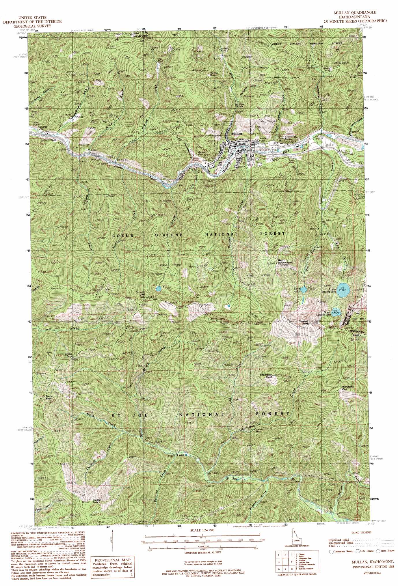
Mullan Topo Map Idaho
To zoom in, hover over the map of Mullan
USGS Topo Quad 47115d7 - 1:24,000 scale
| Topo Map Name: | Mullan |
| USGS Topo Quad ID: | 47115d7 |
| Print Size: | ca. 21 1/4" wide x 27" high |
| Southeast Coordinates: | 47.375° N latitude / 115.75° W longitude |
| Map Center Coordinates: | 47.4375° N latitude / 115.8125° W longitude |
| U.S. States: | ID, MT |
| Filename: | o47115d7.jpg |
| Download Map JPG Image: | Mullan topo map 1:24,000 scale |
| Map Type: | Topographic |
| Topo Series: | 7.5´ |
| Map Scale: | 1:24,000 |
| Source of Map Images: | United States Geological Survey (USGS) |
| Alternate Map Versions: |
Mullan ID 1988, updated 1988 Download PDF Buy paper map Mullan ID 1995, updated 1998 Download PDF Buy paper map Mullan ID 2011 Download PDF Buy paper map Mullan ID 2013 Download PDF Buy paper map |
| FStopo: | US Forest Service topo Mullan is available: Download FStopo PDF Download FStopo TIF |
1:24,000 Topo Quads surrounding Mullan
Grizzly Mountain |
Prichard |
Murray |
Black Peak |
Helwick Peak |
Kellogg East |
Osburn |
Burke |
Thompson Pass |
Driveway Peak |
Polaris Peak |
Wallace |
Mullan |
Lookout Pass |
Saltese |
Marble Creek |
Mastodon Mountain |
Avery |
Shefoot Mountain |
Adair |
Marble Mountain |
Hoyt Mountain |
Fishhook Creek |
Three Sisters |
Thor Mountain |
> Back to 47115a1 at 1:100,000 scale
> Back to 47114a1 at 1:250,000 scale
> Back to U.S. Topo Maps home
Mullan topo map: Gazetteer
Mullan: Dams
Lucky Friday Number One Dam elevation 999m 3277′Lucky Friday Number Three Dam elevation 1119m 3671′
Mullan: Gaps
Moon Pass elevation 1503m 4931′Mullan: Lakes
Lone Lake elevation 1703m 5587′Lower Stevens Lake elevation 1690m 5544′
Upper Stevens Lake elevation 1751m 5744′
Mullan: Mines
Alice Mine elevation 1085m 3559′Carbonate Hill Mine elevation 1269m 4163′
Copper King Mine elevation 1330m 4363′
Gold Hunter Mine elevation 1171m 3841′
Lucky Friday Mine elevation 1056m 3464′
Morning Mine elevation 1008m 3307′
Morning Mine 4 elevation 1367m 4484′
Morning Mine 5 elevation 1316m 4317′
National Mine elevation 1226m 4022′
Reindeer Queen Mine elevation 1367m 4484′
S Bridge elevation 1181m 3874′
Star Mine elevation 1469m 4819′
Sumner Mine elevation 1158m 3799′
Wonder Mine elevation 1226m 4022′
Mullan: Populated Places
Carbonate (historical) elevation 1214m 3982′Golconda elevation 894m 2933′
Mullan elevation 999m 3277′
Stull elevation 922m 3024′
Mullan: Ridges
Coeur d'Alene Saint Joe Divide elevation 1732m 5682′Mullan: Streams
Boulder Creek elevation 996m 3267′Bullion Creek elevation 960m 3149′
Callahan Creek elevation 1089m 3572′
Champion Creek elevation 1030m 3379′
Dry Creek elevation 963m 3159′
East Fork Willow Creek elevation 1246m 4087′
Gold Creek elevation 952m 3123′
Mill Creek elevation 1008m 3307′
Moon Creek elevation 1092m 3582′
Park Creek elevation 1094m 3589′
Railroad Creek elevation 1049m 3441′
Ramsey Creek elevation 1002m 3287′
Rock Creek elevation 909m 2982′
Rougin Creek elevation 1165m 3822′
Saint Joe Creek elevation 933m 3061′
West Fork Willow Creek elevation 1246m 4087′
Willow Creek elevation 1031m 3382′
Mullan: Summits
Champion Point elevation 1832m 6010′Gibson Point elevation 1670m 5479′
Gold Hill elevation 1902m 6240′
Moon Peak elevation 1726m 5662′
Stevens Peak elevation 2069m 6788′
West Grouse Peak elevation 1866m 6122′
West Willow Peak elevation 1921m 6302′
Wonderful Peak elevation 1821m 5974′
Mullan: Trails
Slate Divide Trail elevation 1622m 5321′Wonderful Trail elevation 1588m 5209′
Mullan: Valleys
Deadman Gulch elevation 1034m 3392′Gentle Annie Gulch elevation 1071m 3513′
Gold Hunter Gulch elevation 1036m 3398′
Grouse Gulch elevation 937m 3074′
Paymaster Gulch elevation 1136m 3727′
Ruddy Gulch elevation 927m 3041′
Slaughterhouse Gulch elevation 1027m 3369′
Trowbridge Gulch elevation 935m 3067′
Mullan digital topo map on disk
Buy this Mullan topo map showing relief, roads, GPS coordinates and other geographical features, as a high-resolution digital map file on DVD: