Bloom Peak Topo Map Montana
To zoom in, hover over the map of Bloom Peak
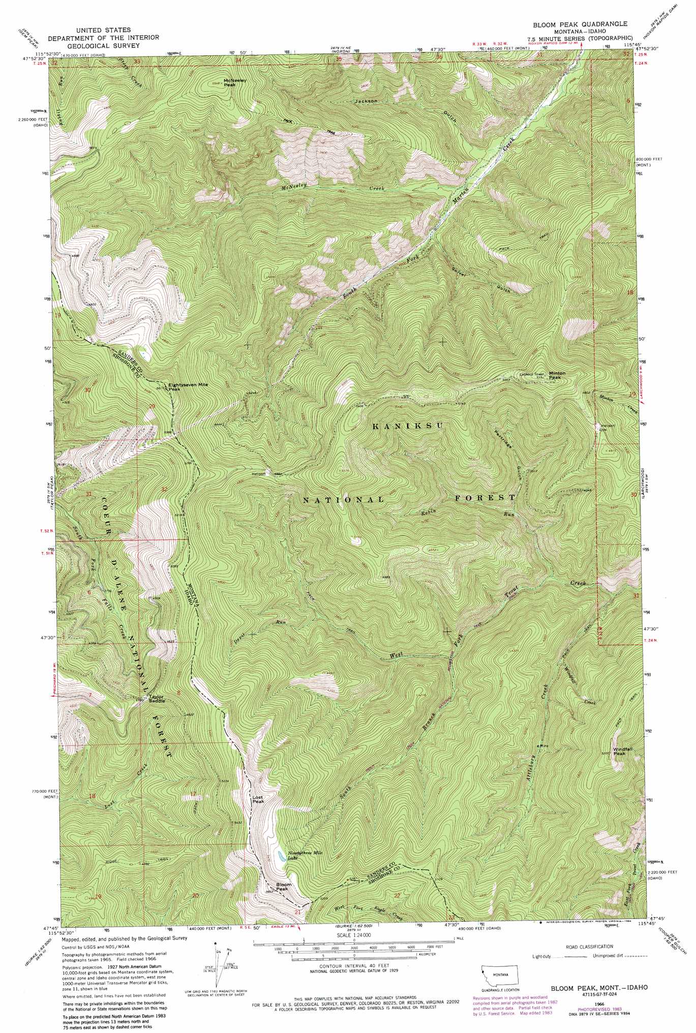
USGS Topo Quad 47115g7 - 1:24,000 scale
| Topo Map Name: | Bloom Peak |
| USGS Topo Quad ID: | 47115g7 |
| Print Size: | ca. 21 1/4" wide x 27" high |
| Southeast Coordinates: | 47.75° N latitude / 115.75° W longitude |
| Map Center Coordinates: | 47.8125° N latitude / 115.8125° W longitude |
| U.S. States: | MT, ID |
| Filename: | o47115g7.jpg |
| Download Map JPG Image: | Bloom Peak topo map 1:24,000 scale |
| Map Type: | Topographic |
| Topo Series: | 7.5´ |
| Map Scale: | 1:24,000 |
| Source of Map Images: | United States Geological Survey (USGS) |
| Alternate Map Versions: |
Bloom Peak MT 1966, updated 1971 Download PDF Buy paper map Bloom Peak MT 1966, updated 1984 Download PDF Buy paper map Bloom Peak MT 1997, updated 2000 Download PDF Buy paper map Bloom Peak MT 2011 Download PDF Buy paper map Bloom Peak MT 2014 Download PDF Buy paper map |
| FStopo: | US Forest Service topo Bloom Peak is available: Download FStopo PDF Download FStopo TIF |
1:24,000 Topo Quads surrounding Bloom Peak
Cabinet |
Heron |
Smeads Bench |
Elephant Peak |
Howard Lake |
Jordan Creek |
Gem Peak |
Noxon |
Noxon Rapids Dam |
Goat Peak |
Pond Peak |
Taylor Peak |
Bloom Peak |
Larchwood |
Trout Creek |
Grizzly Mountain |
Prichard |
Murray |
Black Peak |
Helwick Peak |
Kellogg East |
Osburn |
Burke |
Thompson Pass |
Driveway Peak |
> Back to 47115e1 at 1:100,000 scale
> Back to 47114a1 at 1:250,000 scale
> Back to U.S. Topo Maps home
Bloom Peak topo map: Gazetteer
Bloom Peak: Gaps
Taylor Saddle elevation 1457m 4780′Bloom Peak: Lakes
Ninetythree Mile Lake elevation 1617m 5305′Bloom Peak: Streams
Attlebury Creek elevation 899m 2949′Devil Run elevation 1082m 3549′
McNeeley Creek elevation 775m 2542′
Robin Run elevation 924m 3031′
South Branch West Fork Trout Creek elevation 998m 3274′
Windfall Creek elevation 1028m 3372′
Bloom Peak: Summits
Bloom Peak elevation 1765m 5790′Bloom Peak elevation 1787m 5862′
Eightyseven Mile Peak elevation 1710m 5610′
Eightyseven Mile Peak elevation 1701m 5580′
Lost Peak elevation 1812m 5944′
Lost Peak elevation 1809m 5935′
McNeeley Peak elevation 1692m 5551′
Minton Peak elevation 1628m 5341′
Windfall Peak elevation 1588m 5209′
Bloom Peak: Valleys
Jackson Gulch elevation 759m 2490′Partridge Gulch elevation 1001m 3284′
Sorrel Gulch elevation 789m 2588′
Bloom Peak digital topo map on disk
Buy this Bloom Peak topo map showing relief, roads, GPS coordinates and other geographical features, as a high-resolution digital map file on DVD: