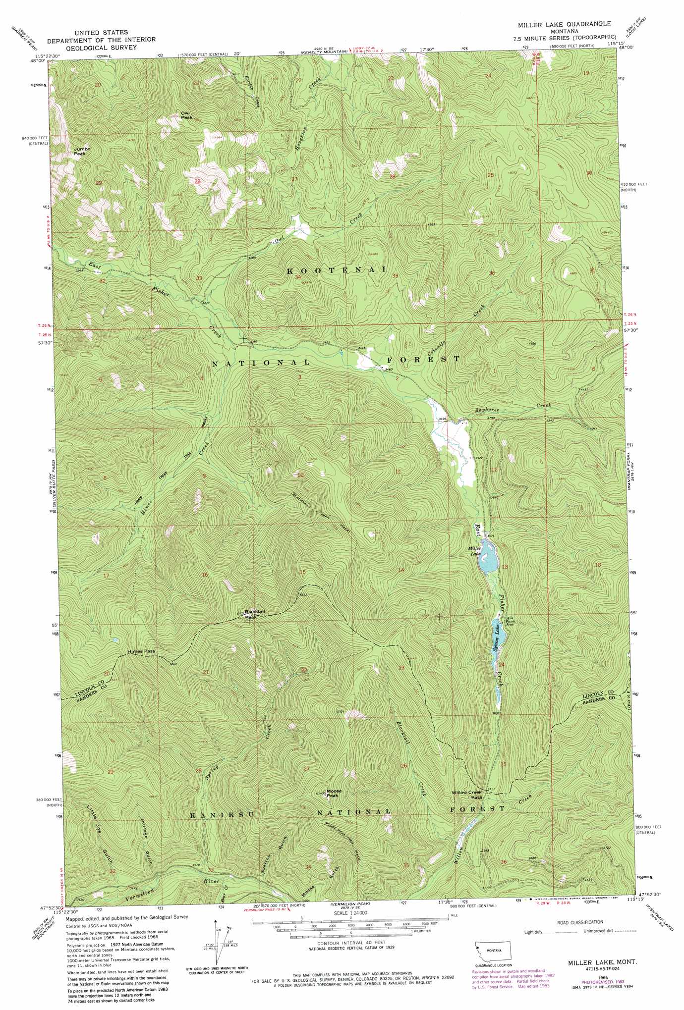
Miller Lake Topo Map Montana
To zoom in, hover over the map of Miller Lake
USGS Topo Quad 47115h3 - 1:24,000 scale
| Topo Map Name: | Miller Lake |
| USGS Topo Quad ID: | 47115h3 |
| Print Size: | ca. 21 1/4" wide x 27" high |
| Southeast Coordinates: | 47.875° N latitude / 115.25° W longitude |
| Map Center Coordinates: | 47.9375° N latitude / 115.3125° W longitude |
| U.S. State: | MT |
| Filename: | o47115h3.jpg |
| Download Map JPG Image: | Miller Lake topo map 1:24,000 scale |
| Map Type: | Topographic |
| Topo Series: | 7.5´ |
| Map Scale: | 1:24,000 |
| Source of Map Images: | United States Geological Survey (USGS) |
| Alternate Map Versions: |
Miller Lake MT 1966, updated 1971 Download PDF Buy paper map Miller Lake MT 1966, updated 1984 Download PDF Buy paper map Miller Lake MT 1997, updated 2000 Download PDF Buy paper map Miller Lake MT 2011 Download PDF Buy paper map Miller Lake MT 2014 Download PDF Buy paper map |
| FStopo: | US Forest Service topo Miller Lake is available: Download FStopo PDF Download FStopo TIF |
1:24,000 Topo Quads surrounding Miller Lake
Cable Mountain |
Horse Mountain |
Fisher Mountain |
Calx Mountain |
Deer Creek |
Howard Lake |
Barren Peak |
Kenelty Mountain |
Loon Lake |
Thompson Lakes |
Goat Peak |
Silver Butte Pass |
Miller Lake |
Mantrap Fork |
Bend |
Trout Creek |
Seven Point Mountain |
Vermilion Peak |
Fishtrap Lake |
Richards Peak |
Helwick Peak |
Belknap |
Mount Headley |
Priscilla Peak |
Calico Creek |
> Back to 47115e1 at 1:100,000 scale
> Back to 47114a1 at 1:250,000 scale
> Back to U.S. Topo Maps home
Miller Lake topo map: Gazetteer
Miller Lake: Falls
Vermilion Falls elevation 1040m 3412′Miller Lake: Gaps
Himes Pass elevation 1500m 4921′Willow Creek Pass elevation 1130m 3707′
Miller Lake: Lakes
Miller Lake elevation 1081m 3546′Sylvan Lake elevation 1093m 3585′
Miller Lake: Streams
Bayhorse Creek elevation 1057m 3467′Bear Creek elevation 1047m 3435′
Blacktail Creek elevation 1119m 3671′
Colonite Creek elevation 1050m 3444′
Himes Creek elevation 1017m 3336′
Owl Creek elevation 1020m 3346′
Spring Creek elevation 1044m 3425′
Miller Lake: Summits
Blacktail Peak elevation 1860m 6102′Jumbo Peak elevation 1639m 5377′
Moose Peak elevation 1834m 6017′
Owl Peak elevation 1546m 5072′
Miller Lake: Trails
Blacktail Trail elevation 1345m 4412′Moose Peak Trail elevation 1507m 4944′
Miller Lake: Valleys
Little Joe Gulch elevation 992m 3254′Sparrow Gulch elevation 1057m 3467′
Thirteen Gulch elevation 1024m 3359′
Miller Lake digital topo map on disk
Buy this Miller Lake topo map showing relief, roads, GPS coordinates and other geographical features, as a high-resolution digital map file on DVD: