Noxon Topo Map Montana
To zoom in, hover over the map of Noxon
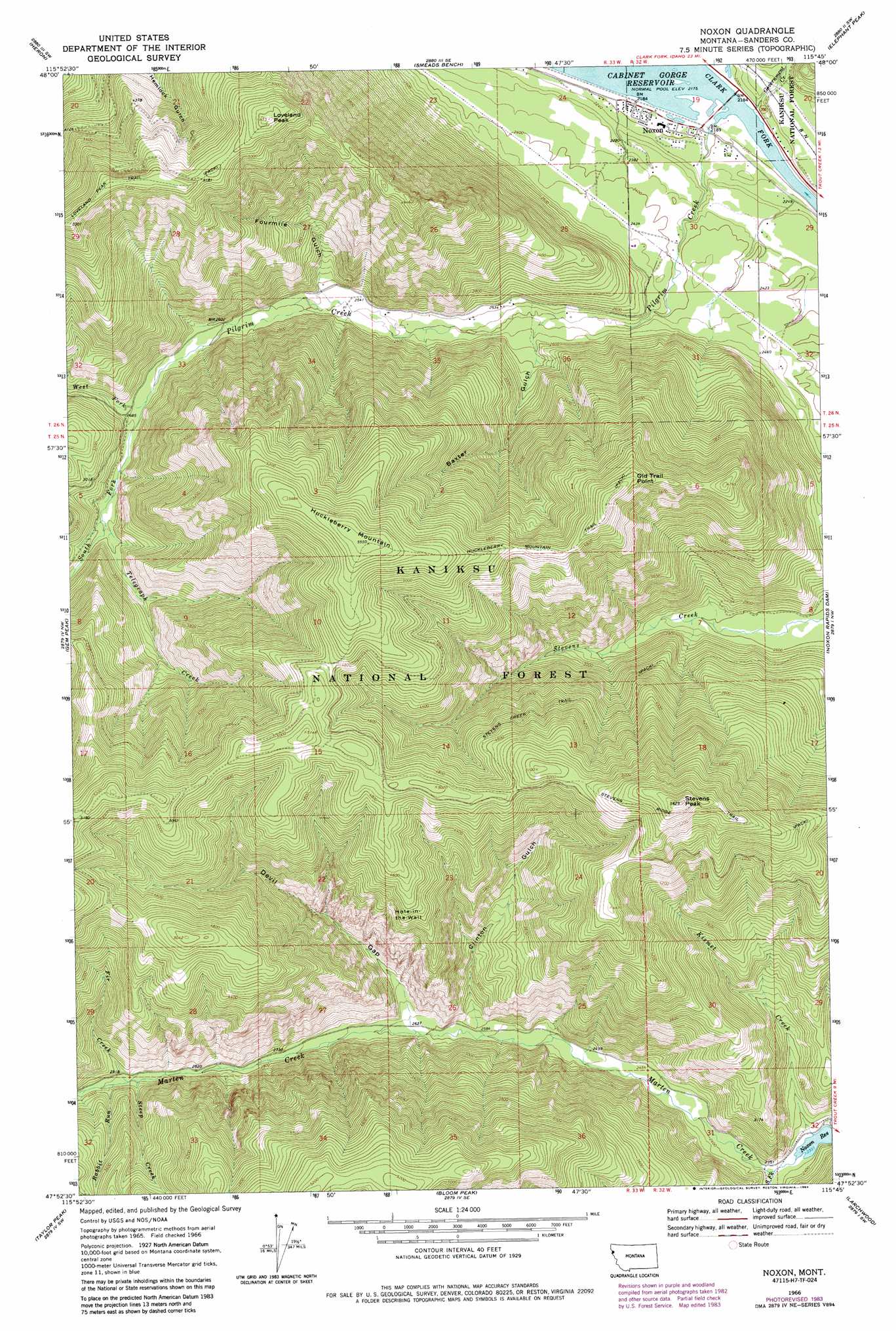
USGS Topo Quad 47115h7 - 1:24,000 scale
| Topo Map Name: | Noxon |
| USGS Topo Quad ID: | 47115h7 |
| Print Size: | ca. 21 1/4" wide x 27" high |
| Southeast Coordinates: | 47.875° N latitude / 115.75° W longitude |
| Map Center Coordinates: | 47.9375° N latitude / 115.8125° W longitude |
| U.S. State: | MT |
| Filename: | o47115h7.jpg |
| Download Map JPG Image: | Noxon topo map 1:24,000 scale |
| Map Type: | Topographic |
| Topo Series: | 7.5´ |
| Map Scale: | 1:24,000 |
| Source of Map Images: | United States Geological Survey (USGS) |
| Alternate Map Versions: |
Noxon MT 1966, updated 1971 Download PDF Buy paper map Noxon MT 1966, updated 1984 Download PDF Buy paper map Noxon MT 1997, updated 2000 Download PDF Buy paper map Noxon MT 2011 Download PDF Buy paper map Noxon MT 2014 Download PDF Buy paper map |
| FStopo: | US Forest Service topo Noxon is available: Download FStopo PDF Download FStopo TIF |
1:24,000 Topo Quads surrounding Noxon
Scotchman Peak |
Sawtooth Mountain |
Ibex Peak |
Snowshoe Peak |
Cable Mountain |
Cabinet |
Heron |
Smeads Bench |
Elephant Peak |
Howard Lake |
Jordan Creek |
Gem Peak |
Noxon |
Noxon Rapids Dam |
Goat Peak |
Pond Peak |
Taylor Peak |
Bloom Peak |
Larchwood |
Trout Creek |
Grizzly Mountain |
Prichard |
Murray |
Black Peak |
Helwick Peak |
> Back to 47115e1 at 1:100,000 scale
> Back to 47114a1 at 1:250,000 scale
> Back to U.S. Topo Maps home
Noxon topo map: Gazetteer
Noxon: Basins
Hole-in-the-Wall elevation 1185m 3887′Noxon: Bridges
Noxon Bridge elevation 664m 2178′Noxon: Cliffs
Old Trail Point elevation 1539m 5049′Noxon: Mines
White Star Mine elevation 947m 3106′Noxon: Populated Places
Noxon elevation 666m 2185′Noxon: Post Offices
Noxon Post Office elevation 666m 2185′Noxon: Streams
Fir Creek elevation 882m 2893′Government Creek elevation 665m 2181′
Kismet Creek elevation 713m 2339′
Marten Creek elevation 712m 2335′
Pilgrim Creek elevation 664m 2178′
Rabbit Run elevation 888m 2913′
South Fork Marten Creek elevation 713m 2339′
South Fork Pilgrim Creek elevation 810m 2657′
Steep Creek elevation 879m 2883′
Telegraph Creek elevation 842m 2762′
West Fork Pilgrim Creek elevation 810m 2657′
Noxon: Summits
Huckleberry Mountain elevation 1690m 5544′Loveland Peak elevation 1661m 5449′
Stevens Peak elevation 1712m 5616′
Noxon: Trails
Huckleberry Mountain Trail elevation 1489m 4885′Stevens Creek Trail elevation 1267m 4156′
Stevens Ridge Trail elevation 1523m 4996′
Noxon: Valleys
Baxter Gulch elevation 749m 2457′Clinton Gulch elevation 783m 2568′
Devil Gap elevation 800m 2624′
Fourmile Gulch elevation 779m 2555′
Noxon: Wells
26N32W19CDDB01 Well elevation 680m 2230′26N32W30BABA01 Well elevation 709m 2326′
26N33W25ADDA01 Well elevation 742m 2434′
Noxon digital topo map on disk
Buy this Noxon topo map showing relief, roads, GPS coordinates and other geographical features, as a high-resolution digital map file on DVD: