Sanders Topo Map Idaho
To zoom in, hover over the map of Sanders
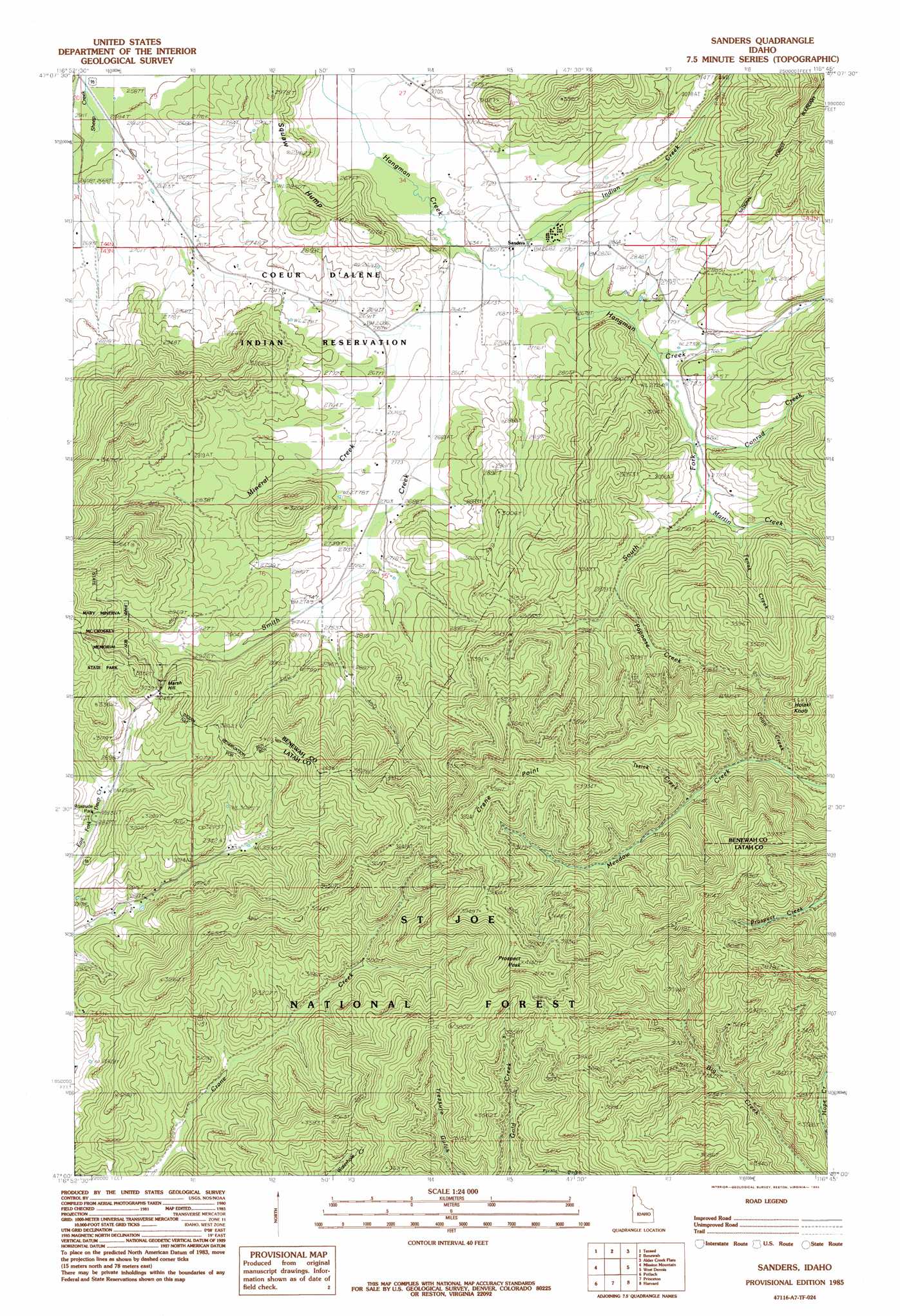
USGS Topo Quad 47116a7 - 1:24,000 scale
| Topo Map Name: | Sanders |
| USGS Topo Quad ID: | 47116a7 |
| Print Size: | ca. 21 1/4" wide x 27" high |
| Southeast Coordinates: | 47° N latitude / 116.75° W longitude |
| Map Center Coordinates: | 47.0625° N latitude / 116.8125° W longitude |
| U.S. State: | ID |
| Filename: | o47116a7.jpg |
| Download Map JPG Image: | Sanders topo map 1:24,000 scale |
| Map Type: | Topographic |
| Topo Series: | 7.5´ |
| Map Scale: | 1:24,000 |
| Source of Map Images: | United States Geological Survey (USGS) |
| Alternate Map Versions: |
Sanders ID 1985, updated 1985 Download PDF Buy paper map Sanders ID 1994, updated 1997 Download PDF Buy paper map Sanders ID 1994, updated 1997 Download PDF Buy paper map Sanders ID 2011 Download PDF Buy paper map Sanders ID 2013 Download PDF Buy paper map |
| FStopo: | US Forest Service topo Sanders is available: Download FStopo PDF Download FStopo TIF |
1:24,000 Topo Quads surrounding Sanders
Tekoa Mountain |
Plummer |
Chatcolet |
Benewah Lake |
Saint Maries |
Tekoa |
Tensed |
Benewah |
Alder Creek Flats |
Lindstrom Peak |
Farmington |
Mission Mountain |
Sanders |
West Dennis |
Emida |
Palouse |
Potlatch |
Princeton |
Harvard |
Sand Mountain |
Viola |
Robinson Lake |
Moscow Mountain |
Stanford |
Deary |
> Back to 47116a1 at 1:100,000 scale
> Back to 47116a1 at 1:250,000 scale
> Back to U.S. Topo Maps home
Sanders topo map: Gazetteer
Sanders: Parks
Roadside Park elevation 861m 2824′Sanders: Populated Places
Sanders elevation 833m 2732′Sanders: Streams
Conrad Creek elevation 844m 2769′Coon Creek elevation 920m 3018′
Indian Creek elevation 812m 2664′
Issick Creek elevation 950m 3116′
Martin Creek elevation 830m 2723′
Mineral Creek elevation 801m 2627′
Papoose Creek elevation 877m 2877′
Smith Creek elevation 809m 2654′
South Fork Hangman Creek elevation 830m 2723′
Tenas Creek elevation 853m 2798′
Sanders: Summits
Crane Point elevation 1211m 3973′Holaki Knob elevation 1112m 3648′
Marsh Hill elevation 991m 3251′
Nehchen Bluff elevation 906m 2972′
Prospect Peak elevation 1255m 4117′
Sanders digital topo map on disk
Buy this Sanders topo map showing relief, roads, GPS coordinates and other geographical features, as a high-resolution digital map file on DVD: