Marble Mountain Topo Map Idaho
To zoom in, hover over the map of Marble Mountain
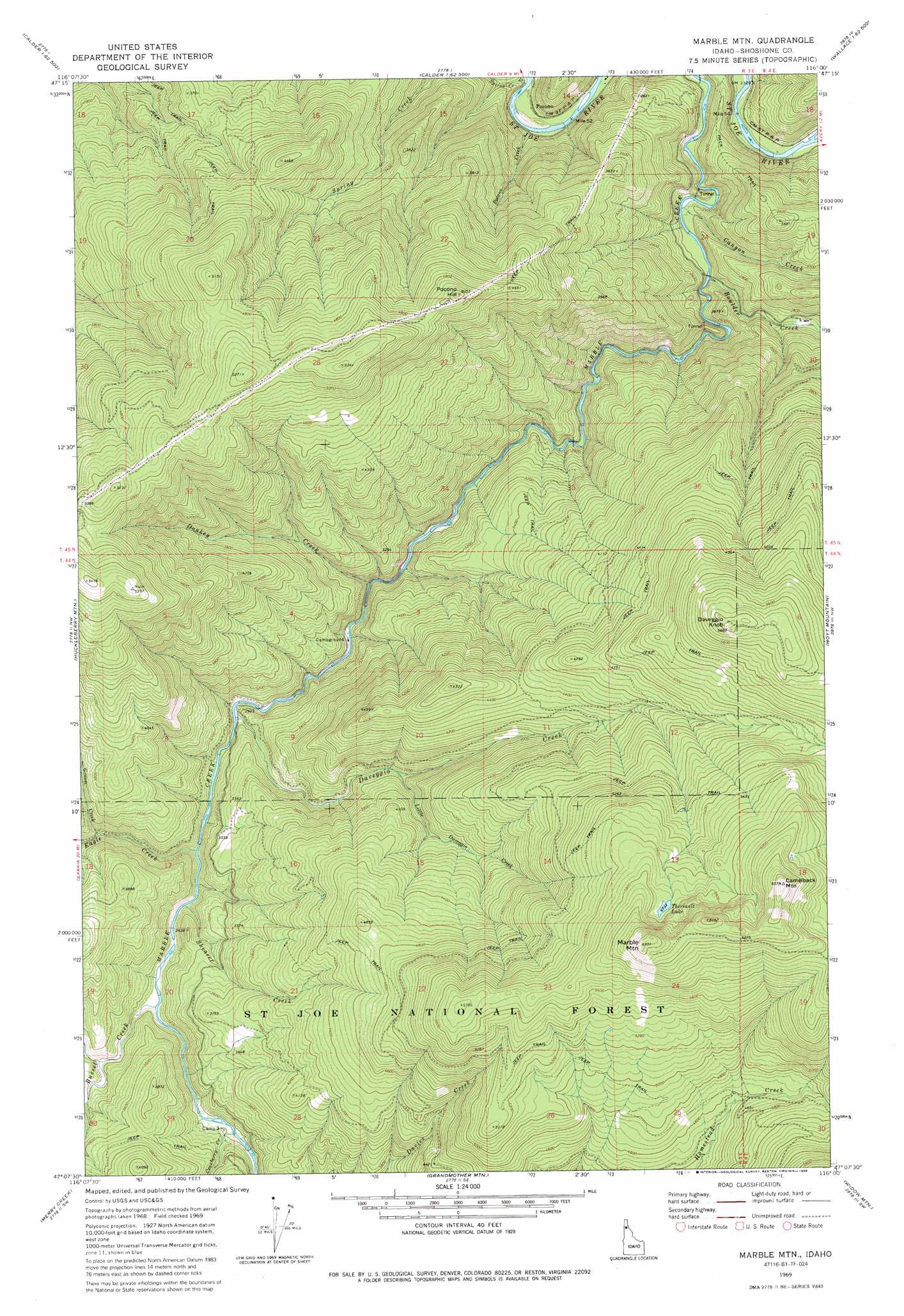
USGS Topo Quad 47116b1 - 1:24,000 scale
| Topo Map Name: | Marble Mountain |
| USGS Topo Quad ID: | 47116b1 |
| Print Size: | ca. 21 1/4" wide x 27" high |
| Southeast Coordinates: | 47.125° N latitude / 116° W longitude |
| Map Center Coordinates: | 47.1875° N latitude / 116.0625° W longitude |
| U.S. State: | ID |
| Filename: | o47116b1.jpg |
| Download Map JPG Image: | Marble Mountain topo map 1:24,000 scale |
| Map Type: | Topographic |
| Topo Series: | 7.5´ |
| Map Scale: | 1:24,000 |
| Source of Map Images: | United States Geological Survey (USGS) |
| Alternate Map Versions: |
Marble Mountain ID 1969, updated 1973 Download PDF Buy paper map Marble Mtn ID 1969, updated 1986 Download PDF Buy paper map Marble Mountain ID 1995, updated 1997 Download PDF Buy paper map Marble Mountain ID 2011 Download PDF Buy paper map Marble Mountain ID 2013 Download PDF Buy paper map |
| FStopo: | US Forest Service topo Marble Mountain is available: Download FStopo PDF Download FStopo TIF |
1:24,000 Topo Quads surrounding Marble Mountain
Twin Crags |
Masonia |
Polaris Peak |
Wallace |
Mullan |
Saint Joe |
Calder |
Marble Creek |
Mastodon Mountain |
Avery |
Crystal Peak |
Huckleberry Mountain |
Marble Mountain |
Hoyt Mountain |
Fishhook Creek |
Clarkia |
Merry Creek |
Grandmother Mountain |
Widow Mountain |
Monumental Buttes |
Bechtel Butte |
Anthony Peak |
Grice Ridge |
Pinchot Butte |
Little Goat Mountains |
> Back to 47116a1 at 1:100,000 scale
> Back to 47116a1 at 1:250,000 scale
> Back to U.S. Topo Maps home
Marble Mountain topo map: Gazetteer
Marble Mountain: Dams
Marble Creek Splash Dam elevation 856m 2808′Marble Mountain: Lakes
Theriault Lake elevation 1754m 5754′Marble Mountain: Populated Places
Pocono elevation 702m 2303′Marble Mountain: Streams
Boulder Creek elevation 742m 2434′Bussel Creek elevation 946m 3103′
Canyon Creek elevation 720m 2362′
Cranberry Creek elevation 973m 3192′
Daveggio Creek elevation 904m 2965′
Donkey Creek elevation 853m 2798′
Eagle Creek elevation 931m 3054′
Grouse Creek elevation 970m 3182′
Little Daveggio Creek elevation 1072m 3517′
Pocono Creek elevation 684m 2244′
Shearer Creek elevation 925m 3034′
Spring Creek elevation 683m 2240′
Marble Mountain: Summits
Camelback Mountain elevation 1996m 6548′Daveggio Knob elevation 1785m 5856′
Marble Mountain elevation 1978m 6489′
Pocono Hill elevation 1536m 5039′
Marble Mountain digital topo map on disk
Buy this Marble Mountain topo map showing relief, roads, GPS coordinates and other geographical features, as a high-resolution digital map file on DVD: