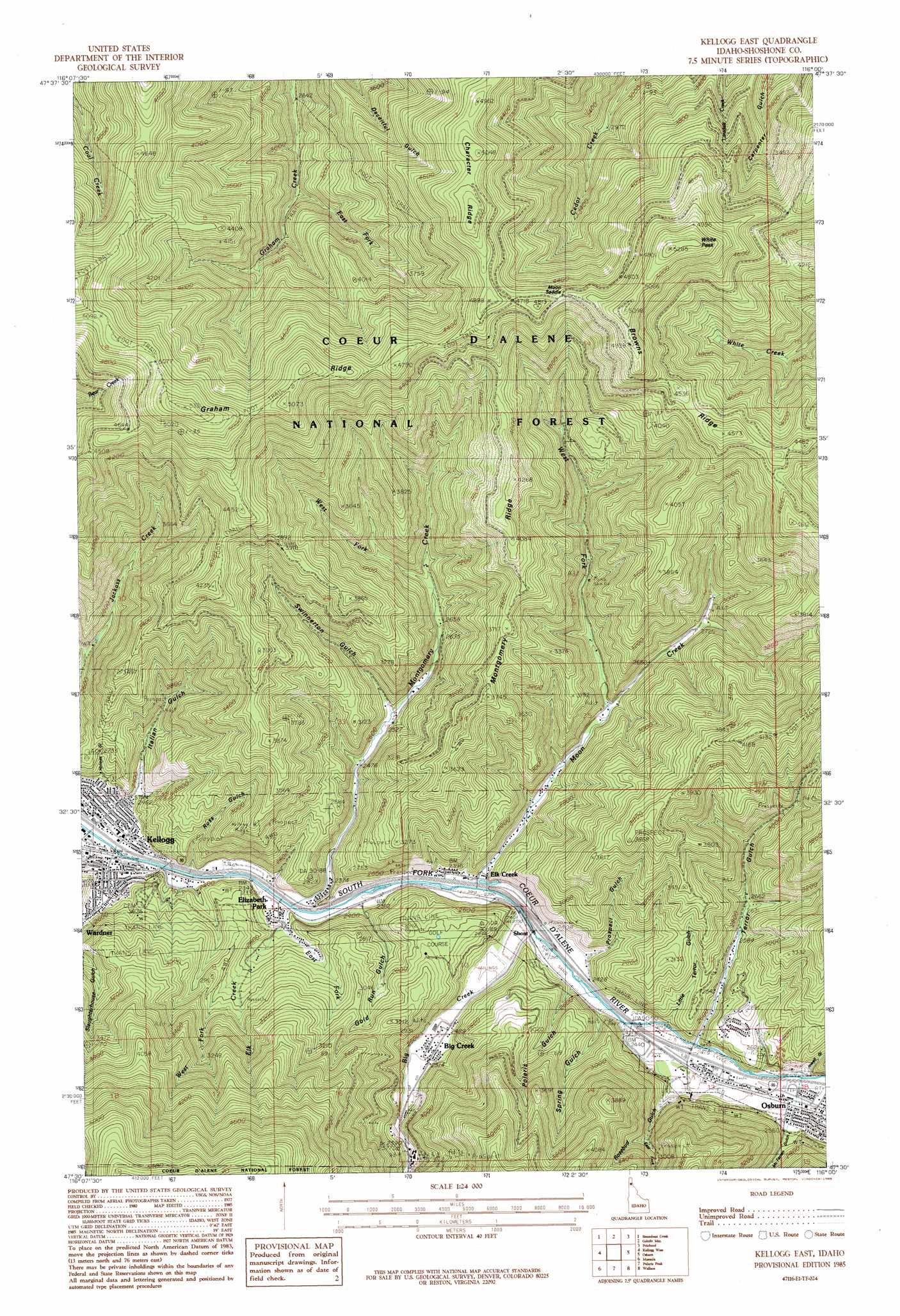
Kellogg East Topo Map Idaho
To zoom in, hover over the map of Kellogg East
USGS Topo Quad 47116e1 - 1:24,000 scale
| Topo Map Name: | Kellogg East |
| USGS Topo Quad ID: | 47116e1 |
| Print Size: | ca. 21 1/4" wide x 27" high |
| Southeast Coordinates: | 47.5° N latitude / 116° W longitude |
| Map Center Coordinates: | 47.5625° N latitude / 116.0625° W longitude |
| U.S. State: | ID |
| Filename: | o47116e1.jpg |
| Download Map JPG Image: | Kellogg East topo map 1:24,000 scale |
| Map Type: | Topographic |
| Topo Series: | 7.5´ |
| Map Scale: | 1:24,000 |
| Source of Map Images: | United States Geological Survey (USGS) |
| Alternate Map Versions: |
Kellogg East ID 1985, updated 1985 Download PDF Buy paper map Kellogg East ID 1985, updated 1985 Download PDF Buy paper map Kellogg East ID 1996, updated 1999 Download PDF Buy paper map Kellogg East ID 2011 Download PDF Buy paper map Kellogg East ID 2014 Download PDF Buy paper map |
| FStopo: | US Forest Service topo Kellogg East is available: Download FStopo PDF Download FStopo TIF |
1:24,000 Topo Quads surrounding Kellogg East
Lamb Peak |
Spyglass Peak |
Pond Peak |
Taylor Peak |
Bloom Peak |
Bumblebee Peak |
Steamboat Creek |
Grizzly Mountain |
Prichard |
Murray |
Cataldo |
Kellogg West |
Kellogg East |
Osburn |
Burke |
Twin Crags |
Masonia |
Polaris Peak |
Wallace |
Mullan |
Saint Joe |
Calder |
Marble Creek |
Mastodon Mountain |
Avery |
> Back to 47116e1 at 1:100,000 scale
> Back to 47116a1 at 1:250,000 scale
> Back to U.S. Topo Maps home
Kellogg East topo map: Gazetteer
Kellogg East: Dams
Sunshine Tailings Number One Dam elevation 737m 2417′Sunshine Tailings Number Two Dam elevation 744m 2440′
Kellogg East: Gaps
Moon Saddle elevation 1423m 4668′White Creek Saddle elevation 1327m 4353′
Kellogg East: Mines
Alhambra Mine elevation 1095m 3592′Crescent Mine elevation 829m 2719′
Mineral Mountain Mine elevation 1070m 3510′
Nellie Mine elevation 1088m 3569′
Polaris Mine elevation 1171m 3841′
Silver Summit Mine elevation 884m 2900′
Sunshine Mine elevation 914m 2998′
Kellogg East: Parks
Gene Day Park elevation 750m 2460′Kellogg East: Populated Places
Elizabeth Park elevation 725m 2378′Elk Creek elevation 732m 2401′
Kellogg elevation 702m 2303′
Kellogg East: Ridges
Browns Ridge elevation 1393m 4570′Character Ridge elevation 1517m 4977′
Montgomery Ridge elevation 1112m 3648′
Kellogg East: Streams
Big Creek elevation 733m 2404′East Fork Elk Creek elevation 739m 2424′
East Fork Graham Creek elevation 860m 2821′
Elk Creek elevation 714m 2342′
Montgomery Creek elevation 714m 2342′
Moon Creek elevation 726m 2381′
West Fork Elk Creek elevation 805m 2641′
West Fork Montgomery Creek elevation 823m 2700′
West Fork Moon Creek elevation 812m 2664′
Kellogg East: Summits
White Peak elevation 1587m 5206′Kellogg East: Trails
Holmes Trail elevation 1269m 4163′Jackass Trail elevation 1550m 5085′
Kellogg East: Valleys
East Fork Rosebud Gulch elevation 909m 2982′Gold Run elevation 731m 2398′
Holmes Gulch elevation 704m 2309′
Italian Gulch elevation 706m 2316′
Jewell Gulch elevation 766m 2513′
Little Terror Gulch elevation 780m 2559′
McFarren Gulch elevation 823m 2700′
Polaris Gulch elevation 769m 2522′
Prospect Gulch elevation 769m 2522′
Rosebud Gulch elevation 761m 2496′
Ross Gulch elevation 757m 2483′
Spring Gulch elevation 763m 2503′
Swinnerton Gulch elevation 786m 2578′
Terror Gulch elevation 752m 2467′
Kellogg East digital topo map on disk
Buy this Kellogg East topo map showing relief, roads, GPS coordinates and other geographical features, as a high-resolution digital map file on DVD: