Grizzly Mountain Topo Map Idaho
To zoom in, hover over the map of Grizzly Mountain
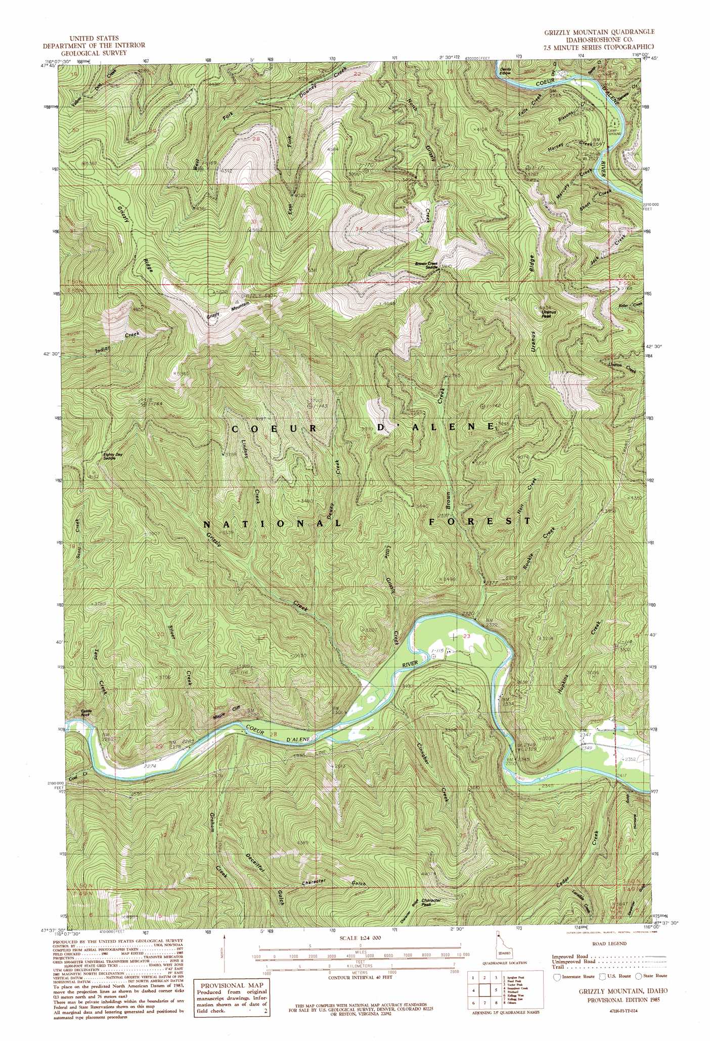
USGS Topo Quad 47116f1 - 1:24,000 scale
| Topo Map Name: | Grizzly Mountain |
| USGS Topo Quad ID: | 47116f1 |
| Print Size: | ca. 21 1/4" wide x 27" high |
| Southeast Coordinates: | 47.625° N latitude / 116° W longitude |
| Map Center Coordinates: | 47.6875° N latitude / 116.0625° W longitude |
| U.S. State: | ID |
| Filename: | o47116f1.jpg |
| Download Map JPG Image: | Grizzly Mountain topo map 1:24,000 scale |
| Map Type: | Topographic |
| Topo Series: | 7.5´ |
| Map Scale: | 1:24,000 |
| Source of Map Images: | United States Geological Survey (USGS) |
| Alternate Map Versions: |
Grizzly Mountain ID 1985, updated 1985 Download PDF Buy paper map Grizzly Mountain ID 1996, updated 1999 Download PDF Buy paper map Grizzly Mountain ID 2011 Download PDF Buy paper map Grizzly Mountain ID 2013 Download PDF Buy paper map |
| FStopo: | US Forest Service topo Grizzly Mountain is available: Download FStopo PDF Download FStopo TIF |
1:24,000 Topo Quads surrounding Grizzly Mountain
Faset Peak |
Cathedral Peak |
Jordan Creek |
Gem Peak |
Noxon |
Lamb Peak |
Spyglass Peak |
Pond Peak |
Taylor Peak |
Bloom Peak |
Bumblebee Peak |
Steamboat Creek |
Grizzly Mountain |
Prichard |
Murray |
Cataldo |
Kellogg West |
Kellogg East |
Osburn |
Burke |
Twin Crags |
Masonia |
Polaris Peak |
Wallace |
Mullan |
> Back to 47116e1 at 1:100,000 scale
> Back to 47116a1 at 1:250,000 scale
> Back to U.S. Topo Maps home
Grizzly Mountain topo map: Gazetteer
Grizzly Mountain: Bends
Devils Elbow elevation 839m 2752′Grizzly Mountain: Cliffs
Castle Rock elevation 792m 2598′Maple Cliff elevation 834m 2736′
Grizzly Mountain: Flats
Kit Price Prairie elevation 775m 2542′Grizzly Mountain: Gaps
Brown Creek Saddle elevation 1164m 3818′Eighty Day Saddle elevation 1225m 4019′
Grizzly Mountain: Populated Places
Nelson (historical) elevation 697m 2286′Grizzly Mountain: Ranges
Coeur d'Alene Mountains elevation 1066m 3497′Grizzly Mountain: Ridges
Uranus Ridge elevation 1344m 4409′Grizzly Mountain: Streams
Brown Creek elevation 706m 2316′Cedar Creek elevation 717m 2352′
Cinnabar Creek elevation 703m 2306′
Coal Creek elevation 696m 2283′
Dewey Creek elevation 766m 2513′
Dry Creek elevation 774m 2539′
East Fork Downey Creek elevation 975m 3198′
Falls Creek elevation 777m 2549′
Graham Creek elevation 696m 2283′
Grizzly Creek elevation 701m 2299′
Hart Creek elevation 766m 2513′
Harvey Creek elevation 772m 2532′
Hopkins Creek elevation 715m 2345′
Lansdale Creek elevation 804m 2637′
Lindsey Creek elevation 829m 2719′
Little Grizzly Creek elevation 700m 2296′
Mercury Creek elevation 770m 2526′
Rookie Creek elevation 717m 2352′
Short Creek elevation 770m 2526′
Silver Creek elevation 704m 2309′
Sissons Creek elevation 774m 2539′
Steep Creek elevation 779m 2555′
Stevens Creek elevation 778m 2552′
Tent Creek elevation 693m 2273′
Venus Creek elevation 770m 2526′
West Fork Downey Creek elevation 975m 3198′
Grizzly Mountain: Summits
Character Peak elevation 1504m 4934′Grizzly Mountain elevation 1800m 5905′
Uranus Peak elevation 1503m 4931′
Grizzly Mountain: Valleys
Character Gulch elevation 920m 3018′Deceitful Gulch elevation 746m 2447′
Hurricane Gulch elevation 749m 2457′
Grizzly Mountain digital topo map on disk
Buy this Grizzly Mountain topo map showing relief, roads, GPS coordinates and other geographical features, as a high-resolution digital map file on DVD: