Ellensburg North Topo Map Washington
To zoom in, hover over the map of Ellensburg North
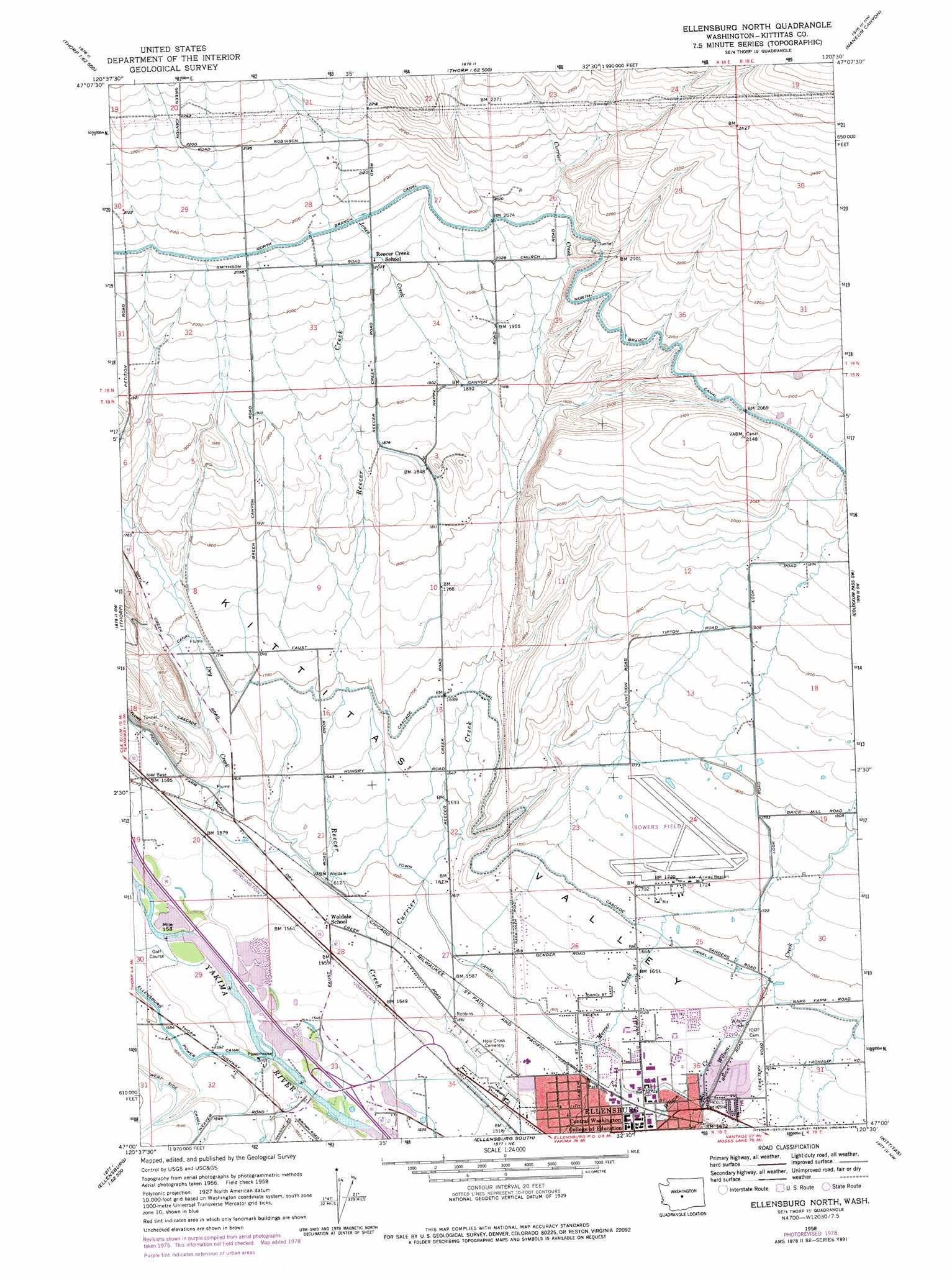
USGS Topo Quad 47120a5 - 1:24,000 scale
| Topo Map Name: | Ellensburg North |
| USGS Topo Quad ID: | 47120a5 |
| Print Size: | ca. 21 1/4" wide x 27" high |
| Southeast Coordinates: | 47° N latitude / 120.5° W longitude |
| Map Center Coordinates: | 47.0625° N latitude / 120.5625° W longitude |
| U.S. State: | WA |
| Filename: | o47120a5.jpg |
| Download Map JPG Image: | Ellensburg North topo map 1:24,000 scale |
| Map Type: | Topographic |
| Topo Series: | 7.5´ |
| Map Scale: | 1:24,000 |
| Source of Map Images: | United States Geological Survey (USGS) |
| Alternate Map Versions: |
Ellensburg North WA 1958, updated 1960 Download PDF Buy paper map Ellensburg North WA 1958, updated 1975 Download PDF Buy paper map Ellensburg North WA 1958, updated 1978 Download PDF Buy paper map Ellensburg North WA 2011 Download PDF Buy paper map Ellensburg North WA 2014 Download PDF Buy paper map |
1:24,000 Topo Quads surrounding Ellensburg North
Red Top Mountain |
Liberty |
Swauk Pass |
Mission Peak |
Wenatchee Heights |
Teanaway |
Swauk Prairie |
Reecer Canyon |
Naneum Canyon |
Colockum Pass |
Taneum Canyon |
Thorp |
Ellensburg North |
Colockum Pass Sw |
Colockum Pass Se |
Hudson Creek |
Manastash Creek |
Ellensburg South |
Kittitas |
East Kittitas |
Milk Canyon |
Wenas Lake |
The Cottonwoods |
Wymer |
Badger Gap |
> Back to 47120a1 at 1:100,000 scale
> Back to 47120a1 at 1:250,000 scale
> Back to U.S. Topo Maps home
Ellensburg North topo map: Gazetteer
Ellensburg North: Airports
Bowers Field elevation 535m 1755′Ellensburg North: Basins
Kittitas Valley elevation 499m 1637′Ellensburg North: Crossings
McManamy Cutoff elevation 488m 1601′West Ellensburg Interchange elevation 469m 1538′
Ellensburg North: Parks
Kiwanis Park elevation 483m 1584′Ellensburg North: Streams
Currier Creek elevation 468m 1535′Dry Creek elevation 477m 1564′
Jones Creek elevation 559m 1833′
Ellensburg North digital topo map on disk
Buy this Ellensburg North topo map showing relief, roads, GPS coordinates and other geographical features, as a high-resolution digital map file on DVD: