West Bar Topo Map Washington
To zoom in, hover over the map of West Bar
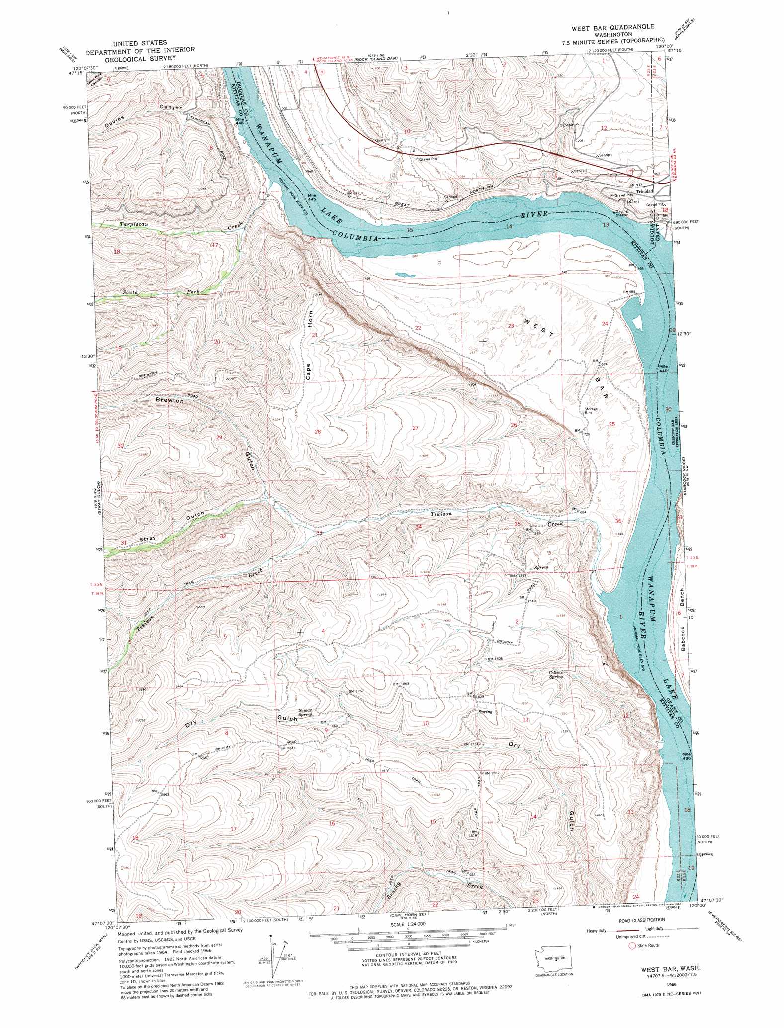
USGS Topo Quad 47120b1 - 1:24,000 scale
| Topo Map Name: | West Bar |
| USGS Topo Quad ID: | 47120b1 |
| Print Size: | ca. 21 1/4" wide x 27" high |
| Southeast Coordinates: | 47.125° N latitude / 120° W longitude |
| Map Center Coordinates: | 47.1875° N latitude / 120.0625° W longitude |
| U.S. State: | WA |
| Filename: | o47120b1.jpg |
| Download Map JPG Image: | West Bar topo map 1:24,000 scale |
| Map Type: | Topographic |
| Topo Series: | 7.5´ |
| Map Scale: | 1:24,000 |
| Source of Map Images: | United States Geological Survey (USGS) |
| Alternate Map Versions: |
West Bar WA 1966, updated 1968 Download PDF Buy paper map West Bar WA 1966, updated 1980 Download PDF Buy paper map West Bar WA 2011 Download PDF Buy paper map West Bar WA 2014 Download PDF Buy paper map |
1:24,000 Topo Quads surrounding West Bar
Wenatchee |
Rock Island |
Malaga Ne |
Palisades |
Rattlesnake Springs |
Wenatchee Heights |
Malaga |
Rock Island Dam |
Appledale |
Monument Hill |
Colockum Pass |
Stray Gulch |
West Bar |
Babcock Ridge |
Quincy |
Colockum Pass Se |
Whiskey Dick Mountain |
Cape Horn Se |
Evergreen Ridge |
George |
East Kittitas |
Boylston |
Ginkgo |
Vantage |
Beverly Ne |
> Back to 47120a1 at 1:100,000 scale
> Back to 47120a1 at 1:250,000 scale
> Back to U.S. Topo Maps home
West Bar topo map: Gazetteer
West Bar: Bars
West Bar elevation 211m 692′West Bar: Populated Places
Trinidad elevation 287m 941′West Bar: Springs
Collins Spring elevation 364m 1194′Sumac Spring elevation 548m 1797′
West Bar: Streams
South Fork Tarpiscan Creek elevation 240m 787′Tarpiscan Creek elevation 177m 580′
Tekison Creek elevation 176m 577′
West Bar: Summits
Cape Horn elevation 649m 2129′West Bar: Valleys
Brewton Gulch elevation 377m 1236′Davies Canyon elevation 176m 577′
Hinkleman Canyon elevation 443m 1453′
Stray Gulch elevation 332m 1089′
West Bar digital topo map on disk
Buy this West Bar topo map showing relief, roads, GPS coordinates and other geographical features, as a high-resolution digital map file on DVD: