Naneum Canyon Topo Map Washington
To zoom in, hover over the map of Naneum Canyon
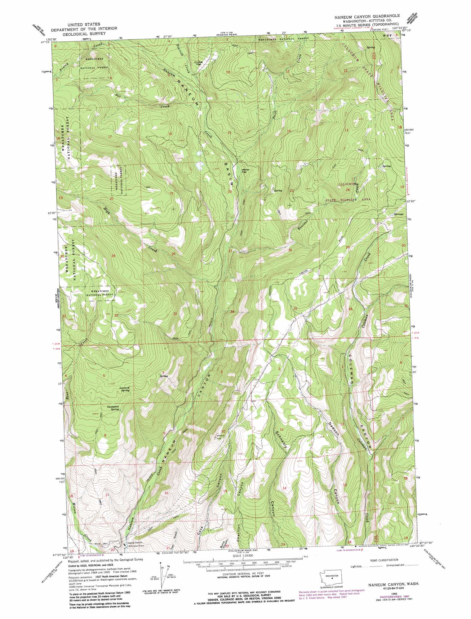
USGS Topo Quad 47120b4 - 1:24,000 scale
| Topo Map Name: | Naneum Canyon |
| USGS Topo Quad ID: | 47120b4 |
| Print Size: | ca. 21 1/4" wide x 27" high |
| Southeast Coordinates: | 47.125° N latitude / 120.375° W longitude |
| Map Center Coordinates: | 47.1875° N latitude / 120.4375° W longitude |
| U.S. State: | WA |
| Filename: | o47120b4.jpg |
| Download Map JPG Image: | Naneum Canyon topo map 1:24,000 scale |
| Map Type: | Topographic |
| Topo Series: | 7.5´ |
| Map Scale: | 1:24,000 |
| Source of Map Images: | United States Geological Survey (USGS) |
| Alternate Map Versions: |
Naneum Canyon WA 1966, updated 1968 Download PDF Buy paper map Naneum Canyon WA 1966, updated 1978 Download PDF Buy paper map Naneum Canyon WA 1966, updated 1987 Download PDF Buy paper map Naneum Canyon WA 1966, updated 1987 Download PDF Buy paper map Naneum Canyon WA 2003, updated 2006 Download PDF Buy paper map Naneum Canyon WA 2011 Download PDF Buy paper map Naneum Canyon WA 2014 Download PDF Buy paper map |
| FStopo: | US Forest Service topo Naneum Canyon is available: Download FStopo PDF Download FStopo TIF |
1:24,000 Topo Quads surrounding Naneum Canyon
Blewett |
Tiptop |
Monitor |
Wenatchee |
Rock Island |
Liberty |
Swauk Pass |
Mission Peak |
Wenatchee Heights |
Malaga |
Swauk Prairie |
Reecer Canyon |
Naneum Canyon |
Colockum Pass |
Stray Gulch |
Thorp |
Ellensburg North |
Colockum Pass Sw |
Colockum Pass Se |
Whiskey Dick Mountain |
Manastash Creek |
Ellensburg South |
Kittitas |
East Kittitas |
Boylston |
> Back to 47120a1 at 1:100,000 scale
> Back to 47120a1 at 1:250,000 scale
> Back to U.S. Topo Maps home
Naneum Canyon topo map: Gazetteer
Naneum Canyon: Basins
Naneum Basin elevation 1077m 3533′Naneum Canyon: Flats
Croker Flat elevation 1160m 3805′Walter Flat elevation 1037m 3402′
Naneum Canyon: Springs
Gustafson Spring elevation 1226m 4022′Leonard Spring elevation 1259m 4130′
Naneum Canyon: Streams
Boulder Creek elevation 971m 3185′Dot Creek elevation 1094m 3589′
High Creek elevation 938m 3077′
Nealey Creek elevation 1198m 3930′
Pearson Creek elevation 1107m 3631′
Swift Creek elevation 1046m 3431′
Naneum Canyon digital topo map on disk
Buy this Naneum Canyon topo map showing relief, roads, GPS coordinates and other geographical features, as a high-resolution digital map file on DVD: