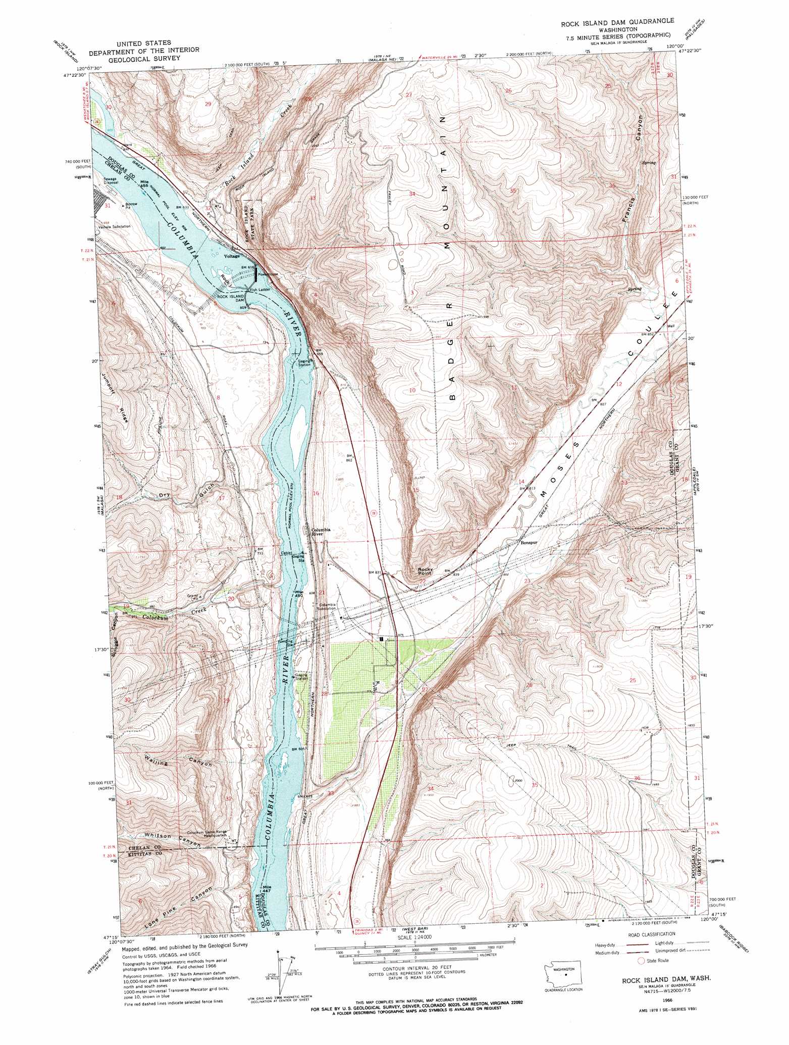
Rock Island Dam Topo Map Washington
To zoom in, hover over the map of Rock Island Dam
USGS Topo Quad 47120c1 - 1:24,000 scale
| Topo Map Name: | Rock Island Dam |
| USGS Topo Quad ID: | 47120c1 |
| Print Size: | ca. 21 1/4" wide x 27" high |
| Southeast Coordinates: | 47.25° N latitude / 120° W longitude |
| Map Center Coordinates: | 47.3125° N latitude / 120.0625° W longitude |
| U.S. State: | WA |
| Filename: | o47120c1.jpg |
| Download Map JPG Image: | Rock Island Dam topo map 1:24,000 scale |
| Map Type: | Topographic |
| Topo Series: | 7.5´ |
| Map Scale: | 1:24,000 |
| Source of Map Images: | United States Geological Survey (USGS) |
| Alternate Map Versions: |
Rock Island Dam WA 1966, updated 1968 Download PDF Buy paper map Rock Island Dam WA 2011 Download PDF Buy paper map Rock Island Dam WA 2014 Download PDF Buy paper map |
1:24,000 Topo Quads surrounding Rock Island Dam
Rocky Reach Dam |
Orondo |
Douglas |
Alstown |
Farmer |
Wenatchee |
Rock Island |
Malaga Ne |
Palisades |
Rattlesnake Springs |
Wenatchee Heights |
Malaga |
Rock Island Dam |
Appledale |
Monument Hill |
Colockum Pass |
Stray Gulch |
West Bar |
Babcock Ridge |
Quincy |
Colockum Pass Se |
Whiskey Dick Mountain |
Cape Horn Se |
Evergreen Ridge |
George |
> Back to 47120a1 at 1:100,000 scale
> Back to 47120a1 at 1:250,000 scale
> Back to U.S. Topo Maps home
Rock Island Dam topo map: Gazetteer
Rock Island Dam: Cliffs
Rocky Point elevation 384m 1259′Rock Island Dam: Dams
Rock Island Dam elevation 175m 574′Rock Island Dam: Islands
Rock Island elevation 186m 610′Rock Island Dam: Lakes
Hammond Lake elevation 186m 610′Rock Island Dam: Parks
Rock Island State Park elevation 349m 1145′Rock Island Dam: Pillars
Lone Rock elevation 289m 948′Rock Island Dam: Populated Places
Voltage elevation 188m 616′Rock Island Dam: Rapids
Cabinet Rapids (historical) elevation 175m 574′Nixon Rapids (historical) elevation 175m 574′
Rock Island Dam: Reservoirs
Rock Island Lake elevation 175m 574′Rock Island Pool elevation 175m 574′
Rock Island Dam: Streams
Colockum Creek elevation 175m 574′Douglas Creek elevation 175m 574′
Rock Island Creek elevation 187m 613′
Rock Island Dam: Valleys
Dry Gulch elevation 175m 574′Francis Canyon elevation 282m 925′
Lone Pine Canyon elevation 175m 574′
Moses Coulee elevation 187m 613′
Scroggie Canyon elevation 306m 1003′
Walling Canyon elevation 175m 574′
Whitson Canyon elevation 175m 574′
Rock Island Dam digital topo map on disk
Buy this Rock Island Dam topo map showing relief, roads, GPS coordinates and other geographical features, as a high-resolution digital map file on DVD: